1999:159 - BALBRIGGAN: Mill Street/George's Hill, Dublin
County: Dublin
Site name: BALBRIGGAN: Mill Street/George's Hill
Sites and Monuments Record No.: 99E0727
Licence number: 99E0727
Author: Daniel Leo Swan, Arch-Tech Ltd.
Author/Organisation Address: 32 Fitzwilliam Place, Dublin 2
Site type: Mill - cotton
Period/Dating: Modern (AD 1750-AD 2000)
ITM: E 720228m, N 763875m
Latitude, Longitude (decimal degrees): 53.610896, -6.183060
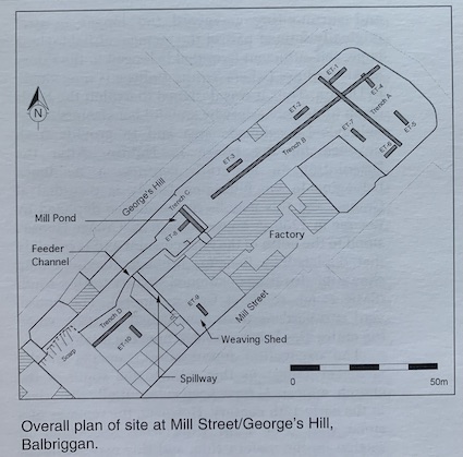
A historical assessment of an extensive area of open ground between Mill Street and George’s Hill, Balbriggan, indicated industrial activity from the late 18th century onwards. This was centred around the Hamilton (later Gallen) cotton works, the main factory building of which is still in use. Inspection of the site following removal of a dense cover of vegetation revealed that most of the elements of the industrial complex depicted on the Ordnance Survey 1:2500 scale map for 1868, and its subsequent revisions, could be clearly identified on the ground. These elements included the millpond, feeder channel, two well-preserved sluice-gates, a spillway, weaving sheds and outbuildings.
This good state of preservation meant that a detailed record of the industrial heritage of the site could be made without recourse to extensive excavation, which was deemed necessary only where the record of activity on the site was unclear and where industrial features were not fully defined. The combined programme of testing and recording was designed to create a detailed record of existing elements of the industrial complex and to identify potentially unrecognised archaeological remains in the area.
Testing was undertaken on 14 and 15 December 1999. Four trenches were opened, three of them in areas of the site where no structures or features had previously been identified. A number of waste pits and boundary features of 19th- and 20th-century date were noted. An area of in situ burning was identified at the base of the topsoil in Trench B to the north-west of the millpond, but no finds or structures were associated with it. Trench C was placed across the millpond in order to clarify its dimensions. This trench established that the deposits infilling the pond were on average only 0.5m thick and appeared to have been recently disturbed, with no clear stratigraphic sequence. The base of the millpond was formed by a roughly mortared surface with a dished profile, dipping to 0.75m below the lip of the sluice-gate at the centre.
Monitoring of ten engineering test-pits was undertaken on 13 December 1999, immediately before the testing programme. No features of archaeological interest were noted.
No structures or elements of the mill complex that had not already been identified from historical or cartographic sources were found on the site. In addition, no archaeological material was recovered during testing or monitoring that would suggest any substantial activity on the site before the late 18th century.