1999:084 - BARRYSCOURT CASTLE, Carrigtwohill, Cork
County: Cork
Site name: BARRYSCOURT CASTLE, Carrigtwohill
Sites and Monuments Record No.: N/A
Licence number: 96E0238
Author: Dave Pollock, ArchaeoGrafix
Author/Organisation Address: Church Lane, Stradbally, Co. Waterford
Site type: Castle - tower house and Bawn
Period/Dating: Multi-period
ITM: E 582257m, N 573281m
Latitude, Longitude (decimal degrees): 51.911390, -8.257880
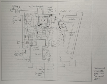
Another season of excavations at Barryscourt completed the investigation of more than half of the bawn area and cut a pair of trenches for drainpipes west of the tower-house. Part of the bawn area opened this season, in front of the tower-house door, would benefit from further investigation.
The tower-house and a second mortared stone building appear to have been built on a green-field site above a stream fed by a nearby spring. The tower-house occupied the corner position of an enclosure defined by a considerable bank and ditch on at least two sides and the ponded watercourse on another. Gun positions in the basement of the tower-house would have covered three sides; the fourth would have been covered from the second mortared building.
The second building overlooked two ponds, at different levels, and had a narrow controlled channel around its other two sides. A potential holding tank for fish has been identified a short distance upstream in the nearby watercourse.
At some stage (in the 16th century) the traditional enclosing bank and ditch were replaced with a string of ponds, but before the present bawn wall was built (in the later 1580s/1590s?) the waterworks were in ruins and the stream had reasserted its meandering course.
The stream was diverted (to its present location?) when the bawn was walled. The new enclosure was divided with an internal wall, restricting access to the north-west. A timber range, most of it one lofty storey over a half-cellar, was built into the corner, overlooking a terraced garden. The garden was probably not maintained for longer than 30 years and should have provided excellent information. However, truncation had generally removed the late 16th/early 17th-century ground level, and the surviving deeper features do not provide a clear design.