1999:080 - BROOKLODGE, Cork
County: Cork
Site name: BROOKLODGE
Sites and Monuments Record No.: N/A
Licence number: 99E0438
Author: Mark Clinton for Margaret Gowen & Co. Ltd.
Author/Organisation Address: 2 Killiney View, Albert Road Lower, Glenageary, Co. Dublin
Site type: Kiln - corn-drying
Period/Dating: Undetermined
ITM: E 574072m, N 575902m
Latitude, Longitude (decimal degrees): 51.934625, -8.377040
This site was discovered during topsoil-stripping in the corridor being prepared for the Little Island to Ballincollig gas pipeline. The site is on the lower slopes of a ridge extending north-north-west/south-south-east. A stream lay 10m to the immediate east. Local information indicated that the kiln was immediately adjacent to the line of an old roadway.
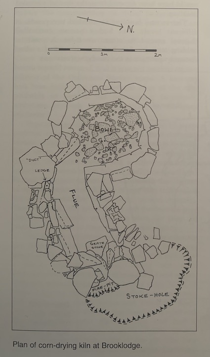
Excavation established the presence of a complete structure consisting of a lintelled flue and an open-topped bowl; a stoke-hole and fire-pit were also uncovered.
The flue extended for 1.7m on a basically north-east/south-west axis. Its floor level maintained a relatively even profile. There were five lintels in situ, although these had been severely damaged by the weight of the heavy machinery. The height of the flue gradually increased from 0.45m to 0.6m; its width varied from 0.5m to 0.8m.
The bowl was almost circular with outwardly battered sides. Its diameter at the top varied from 1.62m to 1.52m, and diameter at floor level from 1.26m to 1.2m. The original height was 0.8m. In an unusual development, the flue and bowl were positioned in a P-shaped configuration.
The floor of the bowl was represented by a loosely set cobble layer. A deliberate arrangement of large rocks had been placed at its junction with the flue. These probably acted as a crude filter (after the fashion of a ‘baffle stone’) that prevented flying embers from entering the bowl.