1999:035 - BALLYCONNEELY, Clare
County: Clare
Site name: BALLYCONNEELY
Sites and Monuments Record No.: N/A
Licence number: 97E0042
Author: Christopher Read, Northwest Archaeological Services, for Valerie J. Keeley Ltd.
Author/Organisation Address: Cloonfad Cottage, Leitrim Village, Co. Roscommon
Site type: Flat cemetery
Period/Dating: Prehistoric (12700 BC-AD 400)
ITM: E 537783m, N 669975m
Latitude, Longitude (decimal degrees): 52.777214, -8.922137
Between 12 July 1999 and 7 April 2000 large-scale excavation and topsoil-stripping were carried out before the N18/19 Road Improvement Scheme. The site was originally tested by Christine Grant in 1997, with a number of potential archaeological features identified (Excavations 1997, 203). The original aim of the project was to investigate two known SMR sites that would be affected by the roadway construction. In the extreme north-west of the site was a standing stone (SMR 42:153), with a large archaeological complex (SMR 42:125) covering the remainder of the area. The archaeological complex consists of a number of early field boundaries and enclosures covering several acres, with only the easternmost portion being affected by the road. The original mandate was to excavate a 10m-by-10m area around the standing stone, culminating in its removal for later re-erection, and two smaller trenches through previously identified early field boundaries. The remainder of the area within the take of the road was to be stripped by machine.
Cutting A, 10m by 10m, was centred on the standing stone at the northern end of the site, which was previously investigated during the testing phase by Christine Grant in 1997 (Excavations 1997, 203). While a number of features cutting the subsoil had been identified, no datable material was retrieved. The recent excavation revealed several features including the foundation of a field boundary and related furrows. Sherds of 19th-century pottery were retrieved from the base of the boundary wall, indicating a likely late date for most, if not all, of the features. None of the other features or contexts contained any datable material.
The base of the standing stone and related stone kerbing was encased in concrete. It rested on loose stone and gravel, filling a shallow circular pit. While the stone was clearly re-erected in the recent past, it remains uncertain whether this was its original position. No dating evidence was retrieved from the cut below the stone. The stone certainly looks like a standing stone, and local legend tells that it was moved to this location in the 19th century from further up the Turret Hill to the north-east. This is in keeping with the dating of the other features revealed in the cutting, with the pit below the standing stone having been cut at the same level as the wall and furrows.
Cutting B, 8m by 2m, was made along the western edge of the site to investigate one of the early field boundaries previously identified. As in the earlier testing phase, no datable materiel was retrieved. The ‘field boundary’ consisted of loose, small to medium-sized stones piled atop a prominent, east-west-orientated ridge of bedrock. While this bedrock may have functioned as a boundary, the loose stones appeared more like field clearance than a concerted effort to build a wall.
Cutting C, 8m by 2m, was made in the extreme southern end of SMR 42:125 to investigate a noticeable north-south-orientated hump and also because this end of the site had not been previously investigated. At the northern limits of the cutting, a stone and gravel trackway was exposed, orientated north-south and resting atop a low linear mound of silty clay. The trackway and both of the layers above and below yielded moderate amounts of animal bone, some worked chert and flint, worked bone and small pieces of copper wire. Beneath the trackway’s foundation layers, a number of pits cutting the subsoil were revealed. Two of these yielded small quantities of bone and charcoal.
Throughout the excavation the remainder of the site within the take of the road was stripped by machine. No further features or finds of an archaeological nature were revealed. Other previously identified field boundaries turned out to be similar to that investigated in Cutting B. The stripping was carried out down to the level of the subsoil where the extensive east-west seams of bedrock allowed.
As the trackway identified in Cutting C clearly extended southwards outside the established perimeter of the SMR site, yet still within the take of the road, an extension to it was opened. This measured 8m north-south by 6m and revealed the full extent of the trackway, with a total length of 8m. While curving slightly to the west, it continued to run roughly north-south. To the south of the trackway’s extent a natural platform, partially obscured by a modern field wall and hedges, was evident and seemed the likely focus of the trackway. The platform is flat on top, c. 35m wide, with its southern end sloping sharply, with panoramic views to the west and south overlooking the Shannon/ Fergus estuary.
In an attempt to include the platform within the scope of the investigation, it was decided to extend the soil-stripping south of the known limit of the site to include the area surrounding the extension to Cutting C, the platform and the area below it, effectively extending the limit of the site by 60m to the south.
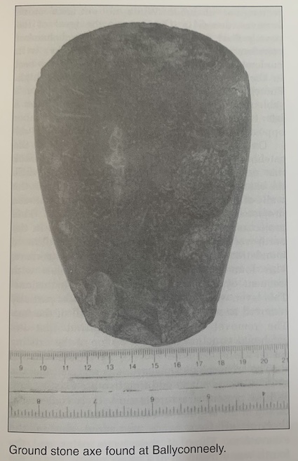
During the initial phase of stripping the platform, a pit cutting the layer above natural was revealed c. 20m south-west of the trackway. The pit was filled with dark soil and charcoal, with the initial investigation revealing a ground stone axe lying directly beneath a large sherd of very coarse pottery. The axe is asymmetrical and highly polished. There is some evidence of use at both ends, although overall the axe is in near-perfect condition. Of particular interest are two circular cupmarks on either face near the top. Each mark appears to have been finely pecked and purposefully sited slightly off line with the other. The pottery is black and very light and crumbly. It has evidence of a slight shoulder and the remains of a small portion of the rim. There is no evidence of decoration. A small quantity of cremated bone was also retrieved.
Owing to the presence of the trackway and the pit, the remainder of the area on the platform (c. 35m by 32m) was cleared by hand down to the archaeological levels. In excess of 600 features cutting the natural subsoil were excavated. These include post-holes, stake-holes, slot-trenches and pits of varying sizes. All were stratigraphically earlier than the trackway.
Most of the post-holes, stake-holes and slot-trenches were clustered in the north-east corner of the platform and indicate likely structural activity, with several possible structures and related pits. Patterns in the placement of these features are not readily discernible at this stage, but circular and oval shapes predominate. No related floors or occupational debris have been identified. There is no reasonable evidence to suggest that this complex of features was related to settlement activity, with the structures likely related in some fashion to the burials found immediately to the south.
The southern and central portions of the platform were dominated by pits of varying size. Most were filled with charcoal-enriched soil, with the larger pits containing considerable quantities of heat-fractured sandstone. The pits ranged in size from small, post-hole-sized cuts (c. 0.01m in diameter) to larger pits, 1m to 2m long. While there is some evidence of pits cutting each other, there is no clear indication of discrete phases of activity. In fact, of the several hundred cut features excavated, it is surprising how closely spaced they were, with so little interference.
Over seventy of the pits excavated yielded small quantities of cremated bone. The bone exhibits evidence of having been efficiently cremated and crushed into tiny pieces. In one case the bone was intentionally cut into small squares. Seven of the pits have yielded pottery of varying types but consistently in small amounts. Most appear to be similar to the Late Bronze Age coarseware found at Mooghaun Hillfort, which is less than three miles away. A few sherds are clearly of finer quality and may be earlier in date. The only other pit, besides that containing the axe, to yield finds other than pottery was a shallow cut between two seams of bedrock in the extreme north-east of the site. This pit yielded two polished bone pins and a tiny (<20mm), serrated, copper-alloy blade, possibly a mini-razor. While the cremated bone has yet to be identified as human, its presence in discrete pits, in consistently small quantities and in association with other burnt material, sherds of Middle to Late Bronze Age pottery and other intentionally deposited finds, may indicate that these pits represent token cremations dating to the Middle to Late Bronze Age.
An early experiment at sieving samples from these and some of the many other pits that did not yield evidence of cremated bone has indicated that some of the pits considered to be relatively sterile have minute quantities of cremated bone and charcoal in them. As post-excavation analysis has just begun, it is possible that upwards of another 100 burials will be identified.
Also within this cluster of pits, a small circular furnace was revealed. It yielded 3–4kg of dull grey slag, mostly in one conglomerate, with layers of large pieces of charcoal beneath. There is no evidence of iron oxide, and the initial feeling is that this is copper slag.