1998:643 - ATHLONE: Northgate Street, Westmeath
County: Westmeath
Site name: ATHLONE: Northgate Street
Sites and Monuments Record No.: N/A
Licence number: 98E0210
Author: Martin E. Byrne
Author/Organisation Address: 39 Kerdiff Park, Monread, Naas, Co. Kildare
Site type: Historic town
Period/Dating: Multi-period
ITM: E 603740m, N 741470m
Latitude, Longitude (decimal degrees): 53.423333, -7.943729
Trial-trenching was undertaken at the site of a proposed hotel, leisure centre and apartment development on 27–9 April 1998. The work was undertaken in compliance with a condition of the grant of planning in respect of the development. Subsurface ground disturbance works had commenced on the site before the involvement of an archaeologist. However, following a report of such to the Garda by Athlone UDC, all works were halted until an archaeologist was present.
The site lies on the east bank of the River Shannon, north of the bridge, and is bounded on the east by Northgate Street. Before development the site consisted of a number of houses fronting onto the street, with the remainder of the site consisting, for the most part, of a disused factory unit. The upstanding remains of the Athlone gasworks building are also within the development site. Demolition of the houses and part of the factory had been completed; the levels had been reduced into the subsoil in much of the south-western quadrant of the site.
The site lies within the walled town of Athlone, and cartographic sources indicate the line of the medieval town wall running west towards the river, in the central part of the site. Furthermore, this wall was reinforced during the 17th century, and a demi-bastion was constructed at the river end. In addition a plan of Athlone dating to 1691 indicates that a number of trenches were dug along the waterfront, within the site, most probably by the Williamites following their breaching of the north bastion.
Trial-trenching indicated that the levels across the southern half of the site had been reduced, probably during the construction of the former factory premises, and that any features of archaeological interest had been removed.
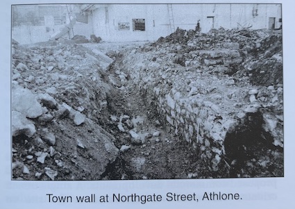
However, investigations along the presumed line of the town wall uncovered the foundation remains of the wall. The nature of the foundations indicated that they are probably medieval in origin, although there were indications that portions were rebuilt, probably in the 17th century. The wall lay up to 4m below the present ground surface and stood to a maximum height of 1.65m. It was up to 1.83m wide and had a slight batter on the internal face.
No further features or finds of archaeological interest were revealed during the course of the evaluation.
The existence of undemolished sections of the former factory building and other extant buildings militated against further archaeological investigations of the site, particularly in the area of the mural defences. Therefore it was decided to cease the evaluation until the remaining demolition works were complete. However, the development ran into financial difficulties, and no further work has been undertaken.
A further planning application in relation to the site has been made, to replace the proposed hotel and leisure centre with apartments. It is intended that demolition works will commence in spring 1999, following which, further archaeological investigations, including the survey of the existing gasworks, will be undertaken.

