1998:634 - DUNGARVAN: Church Street/Emmet Street, Waterford
County: Waterford
Site name: DUNGARVAN: Church Street/Emmet Street
Sites and Monuments Record No.: N/A
Licence number: 97E0325
Author: Dave Pollock
Author/Organisation Address: 33 Woodlawn, Cashel, Co. Tipperary
Site type: Historic town
Period/Dating: Multi-period
ITM: E 625946m, N 592882m
Latitude, Longitude (decimal degrees): 52.087254, -7.621395
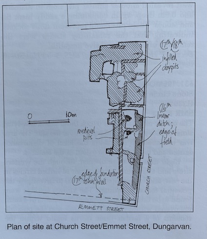
The site for a residential development in the junction of Church Street and Emmett Street, Dungarvan, was tested for archaeological survival in 1997 (Excavations 1997, 182). The site is within the 17th-century town wall, beside the main street from the castle to the medieval church (Church Street). In 1998 a large part of the roadside was investigated.
Two small pits and a few scraps of pebble surface are the only indications of medieval buildings close to the road. No post-holes, slots or hearths were found. Buildings were probably few and only standing for a short time. There were no suggestions of burgage divisions on site. By the 16th century a field occupied half of the roadside; a second field may have occupied the other half. With the 17th-century construction of a town wall (foundations were uncovered) on the line of Emmett Street, soil was stripped from the fields and houses were built beside Church Street. The buildings probably had clay-bonded stone walls, but virtually all traces of walls were removed by later buildings and clay pits.
Clay pits from the 17th and 18th century covered a good deal of the site. Clay extraction started before the construction of the town wall and continued in a belt behind the roadside houses, occasionally cutting away a roadside site. Ground level dropped beside the road and under it. The survival of pre-19th-century surfaces was poor.