1998:526 - SIMONSTOWN, Meath
County: Meath
Site name: SIMONSTOWN
Sites and Monuments Record No.: N/A
Licence number: 98E0352
Author: Cóilín Ó Drisceoil, Archaeological Consultancy Services Ltd.
Author/Organisation Address: 15 Trinity Street, Drogheda, Co. Louth
Site type: Pit-burial
Period/Dating: Multi-period
ITM: E 685084m, N 772457m
Latitude, Longitude (decimal degrees): 53.694884, -6.711633
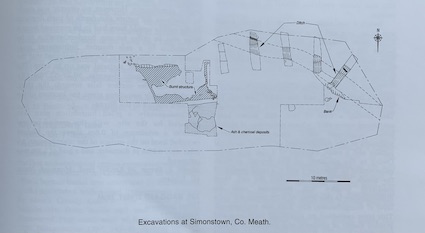
Outokumpo Zinc, Tara Mines Ltd, intends to excavate soil from two borrow areas (Simonstown and Randalstown) for the construction of the Randalstown tailings facility. Monitoring of topsoil-stripping at Simonstown revealed six sites of archaeological potential covering a total of c. 7 acres. Areas 1, 3, 4 and 5 contained 61 circular pits (c. 0.5m in diameter) dug into the subsoil and filled with charcoal and burnt sandstone, and a number were filled with cremated bone. Area 2 contained a linear charcoal deposit. Area 6 was a spread of charcoal and heat-fractured sandstone indicative of a fulacht fiadh. It was decided to excavate Areas 2 and 4, and test-trenches were excavated across three linear ditches in Area 3.
Area 2
Two principal features were excavated: a burnt subrectangular structure and a ditch that may enclose the structure. All archaeological features were exposed and recorded but not removed. The structure had maximum dimensions of 11.3m x 5.8m and was orientated east-west. It consisted of a subrectangular ‘room’ defined by a foundation trench that was filled with charcoal. No internal post-holes have been found. One small post-hole was found 2.4m away from the west wall of the structure. A leaf-shaped arrowhead of probable Neolithic date was found in the fill. The entrance may be in the north-east of the structure, although this area has not been fully investigated. Deposits of charcoal and ash were found directly outside the south ‘wall’ of the house. Radiocarbon samples were taken from the charcoal deposit, and results are awaited.
Six test-trenches were excavated to find the extent of the ditch. It was found running north-east/south-west to the north-east of the burnt structure. The ditch was traced for 15m of its length, after which it ran outside the limit of excavation, although it may return in the west of the site around the burnt structure. The ditch was excavated into the subsoil and had a maximum depth of 0.5m and a maximum width of 1.8m. In profile it was U-shaped. The ditch was truncated by a later field drain. The ditch was filled with a grey, sandy silt, which contained moderate amounts of burnt red sandstone. A deposit of charcoal and burnt stone was a secondary fill. Charcoal from this was collected for radiocarbon dating, and results are awaited. No artefacts were recovered from the fills. A small, stepped cut was found, excavated into the subsoil, outside the ditch. It was 0.1m deep and was traced for 6m in the east of the site. This may be interpreted as the remains of an external bank.
Area 3
One test-trench was excavated across each of three linear ditches. No artefacts were recovered. Charcoal from the fill of the ditch has been submitted for radiocarbon dating.
Area 4
All of Area 4 was investigated. The principal features discovered were a cremation pit, ‘fireplaces’, a post-pit, postholes and cultivation furrows.The cremation pit was excavated into the subsoil. It was subcircular and measured 0.31m x 0.27m and 8.5mm deep. A posthole lay at the base of the pit, sealed under the fill, which consisted of very fragmentary burnt bone and charcoal in a matrix of black-brown, silty clay. The bone has been submitted for palaeopathological analysis. Radiocarbon results from the charcoal are also awaited. Five ‘fireplaces’ were excavated. All were similar and consisted of a simple pit excavated into the subsoil 0.3m x 0.2m and c. 0.1m deep. A fire was lit in the pit, leaving a deposit of ash and charcoal. Four ‘fireplaces’ lay around the south and west of the cremation pit. The fifth was to the south of the others, on top of a portion of the old sod. Radiocarbon results are awaited.The post-pit was subcircular, 0.6m x 0.47m and 0.1m deep. Directly beside the posthole that lay on its east side was a square deposit of orange, oxidised soil. There were a number of different fills of the post-pit. The lining of the base was a thin deposit of charcoal. This underlay a deposit of orange, oxidised soil, which underlay a dark-brown, clayey silt. No artefacts were recovered from the post-pit. It is hoped to obtain a radiocarbon date for the charcoal lining the base.
Altogether six postholes were excavated. Three were near fireplaces, the others have already been mentioned. One posthole was isolated. No evidence of wood survived in the postholes, and no artefacts were found.
Five linear features were excavated. These may be interpreted as cultivation furrows. Late medieval pottery was associated with one of the furrows. They were unevenly distributed throughout the site and showed signs of considerable disturbance.