1998:421 - CARSTOWN, Louth
County: Louth
Site name: CARSTOWN
Sites and Monuments Record No.: SMR 22:37
Licence number: 98E0042
Author: Donald Murphy, Archaeological Consultancy Services Ltd.
Author/Organisation Address: 15 Trinity Street, Drogheda, Co. Louth
Site type: Fulacht fia
Period/Dating: Bronze Age (2200 BC-801 BC)
ITM: E 711547m, N 779466m
Latitude, Longitude (decimal degrees): 53.752867, -6.308580
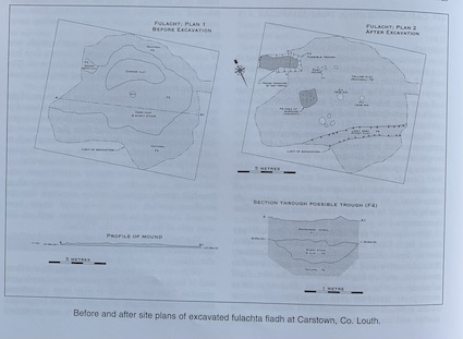
The assessment took place at Carstown, Co. Louth, in advance of a proposed dwelling-house. The site was previously recorded as a burnt mound in the Archaeological Survey of County Louth (site 1245).
After stripping of the topsoil an area of burnt material covering 10m east-west by 6.75m was revealed. The burnt material was composed of fire-cracked sandstone and charcoal-stained clay that was up to 0.24m thick. This rock type is not local to the area. The mound did not have the classic horseshoe shape and was probably damaged by ploughing.
A number of features were cut into the yellow/brown natural boulder clay. A U-shaped gully up to 0.43m deep ran across the south of the site and may have been a deliberately cut ditch to carry water to the site. An oblong trough lay in the north-west of the site and was 3.6m east-west by 1.6m and up to 0.36m deep. There were no traces of a lining, and the feature was filled with burnt stone. Eight postholes close to the trough may have been some form of screen.

