1998:399 - GORTEEN (AR2), Limerick
County: Limerick
Site name: GORTEEN (AR2)
Sites and Monuments Record No.: SMR 21:17
Licence number: 97E0230 ext.
Author: Ciara MacManus, c/o Archaeological Development Services Ltd.
Author/Organisation Address: Windsor House, 11 Fairview Strand, Dublin 3
Site type: Ringfort - rath
Period/Dating: Early Medieval (AD 400-AD 1099)
ITM: E 541635m, N 628240m
Latitude, Longitude (decimal degrees): 52.402568, -8.857698
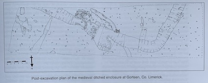
Excavations at AR2, at Gorteen, Co. Limerick, began on 4 November 1998, in advance of road development on the N20 Limerick Bypass scheme and were completed on 15 January 1999. Audrey Gahan uncovered the site, marked in the OS Memoirs as a possible ringfort, through trial-trenching the previous summer (Excavations 1997, 114–15). Only part of the monument lay within the line and take of the road, thus only this portion of the site was to be excavated.
Audrey Gahan had opened a trench, roughly 60m x 15m, along the take of the road in the area of the monument. This revealed part of a rectangular ditched enclosure. The north-west corner of the enclosure, along with its west-facing line running south-west for a distance of 13.5m and the north-east-facing line running south-east for a distance of 31.5m, had been uncovered. Other activity within this trench included two earlier gully features and a number of shallow, pit-like features external to the enclosure.
The ditch itself was fairly uniform in construction, ranging from a V-shaped to U-shaped cut and 3.72m in diameter at its widest point and 2.38m at its narrowest. The depth ranged from 1.43m to 0.2m. At a distance of 20m along the west-facing line of the enclosure from the corner the base of the ditch rose to a depth of 0.2m to form a step, some 3.25m long, before dropping back to the V-shaped cut ditch.
The fill of the ditch was fairly uniform throughout, showing evidence of silting over time. However, portions of the ditch were particularly stony in nature and may have represented the slump of an associated bank with stone facing. The fill also produced a quantity of animal bone and seashell material, along with a sherd of medieval pottery. Parts of the inner face of the ditch had been revetted with stone. This occurred in areas where there had been earlier activity and the edge of the ditch was structurally unsafe. At a distance of c. 9.5m south-east of the corner of the ditch an earlier drain was uncovered running north-west/south-east. Here the inner face of the enclosure ditch was revetted with a dry-stone face, 2m long and 0.42m deep. This earlier drain was V-shaped in section, 1.1m wide and 0.5m deep, containing a stony fill. At a distance of c. 31m south-east of the north-west corner another stone facing was uncovered in an area where another earlier ditch had been. This ditch again ran north-west/south-east and was c. 13.5m long, 3.5m wide and 0.86m deep, becoming shallower (0.44m) at its north-west terminal.
That parts of the inner face of the enclosure’s ditch were revetted, along with the large quantities of stone within the ditch fill, is evidence that the enclosure may have had an inner bank.
The only features found within the enclosure were two very shallow, truncated pits with no obvious function.
Externally in the east end of the trench a number of features were found. The first of these was a small pit, 9m to the north of the ditch, which contained a charcoal-rich fill with burnt stone. This feature may represent a rubbish pit. The other features in this area were two elongated gullies. The earlier (which was cut by the later) ran north-south and measured 4m x 0.98m x 0.3m. The later feature ran north-east/south-west for a distance of c. 5m into the east section of the trench and was 1.15m wide and 0.4m deep. Approximately 1.5m south of these two gullies was another shallow, elongated pit, running into the south section of the trench. This was filled by a dark, peaty, silty material, which contained a number of stones. To the west of this group of features was a furrow, which had been subsequently cut by the enclosure’s ditch.
The results of excavations at AR2 further proved the existence of a rectangular moated enclosure of medieval date. This would have consisted of a rectangular ditch and possible inner bank. However, no evidence was produced from the excavation of an inner raised platform, nor was there any evidence of any internal structure. This lack of evidence, however, is probably due to the fact that not enough of the inside of the enclosure was included in the area of excavation.
The evidence of earlier activity on site was limited to a series of gullies and an earlier ditch, none of which produced any dating evidence.