1998:358 - KILKENNY: Patrick Street/Pudding Lane/Pennyfeather Lane, Kilkenny
County: Kilkenny
Site name: KILKENNY: Patrick Street/Pudding Lane/Pennyfeather Lane
Sites and Monuments Record No.: N/A
Licence number: 97E0468
Author: Judith Carroll, Pine Forest Art Centre
Author/Organisation Address: Pine Forest Road, Glencullen, Co. Dublin
Site type: Historic town
Period/Dating: Multi-period
ITM: E 650499m, N 655724m
Latitude, Longitude (decimal degrees): 52.650365, -7.253689
The site lies between the old city walls at the west and the medieval streets of Patrick Street and Pudding Lane at the east. The excavation was a condition of planning as a result of trial-trenching in December 1997 and January 1998 (Excavations 1997, 104).
The development was initially restricted to Areas 1–4, but during the course of the excavation of these areas, from 29 April to 5 November 1998, the developer acquired an additional plot of land (Area 5), formerly belonging to the Franciscan friary. This necessitated an additional programme of trial-trenching and assessment, based on which the Heritage Service recommended an additional programme of monitoring and further excavation.
The site lies in the south-west of the medieval town, within the city walls, in an area that preserves the medieval layout of streets and land divisions. Patrick Street is shown on William Petty’s 17th-century map of Kilkenny as a main thoroughfare of the town, lined with tall stone houses. Long plots of land typical of medieval burgage plots are shown in the area of the present site, running from the rear of these houses towards, but not reaching, the city wall.
John Rocque’s map of 1758 shows similar plots, extending as far as the sconce that ran inside the city wall and in places apparently abutting the wall itself. Most of the wall lines shown on Rocque’s map were still extant until very recently, some having been demolished as part of the present development. It had been suggested that these walls corresponded with the boundaries of the medieval burgage plots. However, excavation at this site and the preceding work on Nos 26–29 Patrick Street (see No. 356 Excavations 1998) identified many pits and trenches of probable 12th–16th-century date, running under the foundations of the extant wall, suggesting that the original burgage plots had somewhat different lines. The wall at the western end of the site was built between 1240 and 1440, with further work carried out in the 17th century.
Summaries of the results of excavation in each of these areas are presented here in the order in which work was carried out.
Area 4: main hotel area (29 April–27 July 1998)
Area 4 was completely excavated. It runs from the south-west edge of site No. 356, Excavations 1998, to the edge of the area of preservation around the group of upstanding structures tentatively identified as a sallyport bastion and guardhouse/stables once attached to the now demolished Myler’s Tower.
A number of shallow drainage channels of probable medieval date were identified adjacent to the area of preservation in front of the sallyport bastions. At the other end of the area a larger number of small pits and narrow trenches were excavated, some seeming to extend into the area excavated under the licence to the east (No. 356 Excavations 1998). Between these two areas no medieval features were identified, adhering to a pattern of distribution that is also visible in the other areas.
Two very large post-medieval pits of greater than 2m depth were excavated close to the sallyport bastion. Other, smaller post-medieval pits were also excavated in this area. A more dense concentration of post-medieval pits and shallow trenches was present at the eastern end of the area.
Area 2: main hotel area (29 April–27 July 1998)
Area 2 was completely excavated. As with Area 4, features tended to be concentrated at the east and west ends, with a much lower density of features in the central area.
The most notable feature of Area 2 is a well-defined trench, tentatively identified as a palisade ditch, running roughly north-north-west/south-south-east across the eastern end of the area. This is the continuation of the palisade trench excavated in the preceding excavation (98E0092), carried out at the rear of Nos 26–29 Patrick Street, to the south of Area 2 (No. 356 Excavations 1998). As noted below, this feature seems to continue into Area 5 to the north. It was observed during excavation that there was a notably higher concentration of medieval features lying to the east of this ditch than was evident to the west. This pattern was borne out in Areas 2 and 5 as well as in the previous excavation.
Several other substantial medieval ditches were excavated in Area 2, including a steep-sided trench that runs east-north-east/west-south-west for half the length of the northern part of this area. Also of apparent medieval date is a pair of shallow, carefully cut, sub-square, flat-bottomed pits with a deliberate lining of small, well-sorted stones, which appears to be linked to shallow drainage channels. A large number of more substantial medieval pits was excavated to the east of the palisade ditch, many of which continue into the unexcavated section face under the north-south access road that links the 26–29 Patrick Street site to the present development.
Post-medieval features include several large, deep pits, one of which produced an intact pot, and some small, well-defined drainage channels that run east-north-east/west-south-west across the site. A substantial post-medieval feature (or series of merged smaller features) runs across the western end of the site, extending into the area of preservation. As this feature lay predominantly outside the zone of impact, only limited investigation took place.
Also identified were the foundations of plot walls shown on Rocque’s map but subsequently demolished, including the western end-walls of the plots that occupied Area 2.
Area 3: leisure centre (27 July–8 September 1998)
Area 3 was completely excavated, with the Area of Preservation along the line of the city wall forming its western border. A small number of pits were identified in the west of the area. Of these, one was of probable medieval date and the rest appeared to be post-medieval. Two shallow, flat-bottomed ditches running roughly east-west were identified, both quite disturbed but of a probable medieval date.
Four partially intact human burials were excavated, three lying along a rough north-south line with a fourth at right angles to this alignment. Additional disarticulated human bones were recovered from soil in their vicinity, suggesting at least one further individual. The disarticulated partial remains of an adult female had been recovered from a post-medieval pit in the western portion of this area during a previous phase of trial-trenching (Keeley and Grant 1996, Trial-trench 1, 96E0007). The remainder of this pit was investigated during the present excavation, and further disarticulated remains were identified, possibly belonging to the same individual. The date of these burials has not yet been firmly established.
Nearly all features in Area 3 were cut into by a superimposed criss-cross system of shallow, narrow, post-medieval ditches, probably the remnants of cultivation ridges or temporary drainage channels.
Area 1: multi-storey carpark and retail units (27 July–23 October 1998)
On the recommendation of the Heritage Service Area 1 was excavated to formation levels only. Where features extended below formation levels they were not excavated below that depth, except in the south-east corner of Area 1, which was substantially completed before this recommendation. In addition to these partially unexcavated features it is extremely likely that significant archaeological layers still remain in any areas that were not affected by the present development. Most of Area 1 was excavated, and it was characterised by a very high density of features, both medieval and post-medieval.
Area 1 contained a large number of medieval features, including a high density of pits, as well as hearths, structural trenches, stake-holes and evidence of metalworking. Three large hearths of likely medieval date were identified, two of which showed evidence of multiple phases of intense use on successive earthen floor surfaces. Both are close to the probable street front of Pudding Lane. In addition there is extensive evidence of metalworking in the medieval period, with large volumes of slag coming from several apparently medieval pits.
A number of substantial ditches or trenches of probable medieval date were identified, with three running east-north-east/west-south-west and one running north-north-west/south-south-east. A more narrow and shallow, L-shaped trench suggested a truncated house foundation, but most of the feature was below formation levels, and it was not possible to investigate this possibility further.
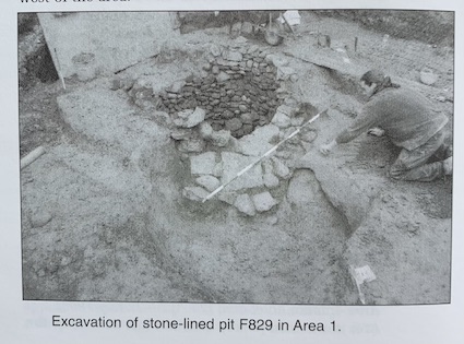
As well as ordinary pits producing large amounts of medieval pottery (including a near-complete pot, cup and jug from separate features), two very large and two smaller stone-lined pits appear to be medieval in date, with very finely set intact dry-stone walling.
Post-medieval features consisted mainly of numerous pits (some very extensive), walls and several drainage features. A badly truncated, brick-lined linear feature filled with material apparently vitrified in situ, as well as quantities of post-medieval pottery and tile, suggests ceramic manufacture on the site.
A fine brick-walled drain capped with substantial stone lintels runs east-north-east/west-south-west for nearly the whole length of the area before turning off at right angles to the north-west at its western end. This feature cuts into and overlies several of the more significant medieval features, and despite its relatively modern fabric its location may reflect an established medieval drain line. Multiple near-parallel lines of deep stake-holes run almost exactly parallel to this drain, just to the south of it, but these have yet to be dated.
Probably dating to the 19th or early 20th century, but worthy of note, is a series of three iron-hooped wooden vats of 3m diameter set into the ground, running roughly east-west down the approximate centre of Area 1. Similarly, three substantial iron-banded mill-wheels, one intact and two broken, were recovered from the overburden in the south-west of the area.
Area 5: multi-storey carpark (extension) (25 September–5 November 1998)
A low density of features was noted here, in keeping with the character of the central band of the site as a whole. Two shallow trenches of a probable medieval date were identified, both running roughly north- south. One of these ditches appears to be the northern continuation of the palisade ditch from Area 2 and No. 356, Excavations 1998. Several pits of post-medieval date were also investigated. The excavation of potential features impinged upon by one remaining undug foundation trench in Area 5 has been deferred, as access is currently prevented by ongoing construction works. This investigation will take place when access becomes available.