1998:357 - KILKENNY: 33 Patrick Street, Kilkenny
County: Kilkenny
Site name: KILKENNY: 33 Patrick Street
Sites and Monuments Record No.: N/A
Licence number: 98E0402
Author: Judith Carroll, Pine Forest Art Centre
Author/Organisation Address: Pine Forest Road, Glencullen, Co. Dublin
Site type: Excavation - miscellaneous
Period/Dating: Multi-period
ITM: E 650658m, N 655593m
Latitude, Longitude (decimal degrees): 52.649173, -7.251360
The site of No. 33 Patrick Street lies within a large area of current development and archaeological excavation. Excavation has taken place at the 26–29 Patrick Street to the south (No. 356, Excavations 1998) and Patrick Street/Pudding Lane to the north, north-west and west (No. 358 Excavations 1998). The development of No. 33 Patrick Street comprises a three-storey extension with basement to the immediate rear of the premises, currently operating as a hotel.
The excavation of the site was a condition of planning permission as a result of the trial-trenching investigation that took place on 10 September 1998.
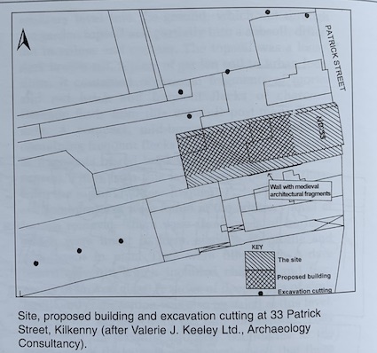
Also part of the assessment was a request for further information regarding the upstanding walls surrounding the site. In response to this a drawn survey of three of the walls, including a 16th/17th-century wall to the south-east of the site, which contained, amongst other features of note, a small ogee-headed window, was carried out by Ben Murtagh.
The development site lies within the medieval city walls in an area that also preserves the medieval layout of streets and land divisions. Pudding Lane to the east and Pennyfeather Lane to the north retain their original narrow shapes, and houses of medieval date would be expected to have fronted onto these lanes. The long, narrow plots of land, which extend back from the properties fronting onto Patrick Street, reflect typical medieval burgage plots. Habitation evidence dating from the medieval period is thus likely to be found in the grounds of the houses fronting onto Patrick Street.
Patrick Street is first recorded on William Petty’s 17th-century map of Kilkenny, and was a main thoroughfare of the medieval town at that time. It was flanked by tall stone houses. A plot corresponding to the stone boundary walls upstanding on the site appears on John Roque’s 1758 map of Kilkenny.
A substantial amount of trial-trenching and excavation has already taken place in the area around the site since 1990. This was carried out by Heather King and John Bradley (Archaeological trial excavations in Kilkenny, Old Kilkenny Review 4 (4), 973–87 and Excavations 1990, 40–1), Christine Grant (96E0007), Margaret Gowen (Excavations 1995, 50–1, 95E0224) and this writer (Excavations 1997, 104), and Nos 356 and 358, Excavations 1998). Full excavation by this writer in all areas around the site has shown that the remains of undisturbed medieval habitation, mainly in the form of medieval pits, as well as foundation trenches and other features, are likely to be found on all areas of all sites fronting onto Patrick Street.
The excavation took place from 21 September to 13 November 1998 over an area c. 25m x 14.5m. Demolition of existing structures to the rear of No. 33 Patrick Street, the removal of an iron security fence and gate and the complete removal of the wall to the north were carried out before the full extent of the site was exposed. Before this an L-shaped area comprising three cuttings within the carpark was excavated. The excavation produced considerable evidence of medieval activity in the form of pottery but evidence also for post-medieval occupation in the form of foundations for a rectangular building following the line of the northern wall and also ground disturbance in the extreme north-eastern corner. Analysis of the pottery and other finds from the site has yet to take place, so any remarks on the dating of the features on site are purely provisional.
At the eastern end of the site was a rectangular arrangement of stone foundations forming two distinct cells of a dwelling, which possibly corresponds to a building shown on John Rocque’s 18th-century map of Kilkenny.
Beneath the 0.02–0.05m-thick layer of tarmac was a 0.1–0.24m thickness of levelling layers, above a single layer of water-worn cobbles of up to 0.15m diameter. These layers also included the bases for the concrete buttresses supporting Wall B to the south. Below the cobbles a 0.25–0.35m-thick layer of rubble (F5) contained fragments of red brick, mortar, slate and lenses of gravel and sand. This lay directly above the first stratified soil layer, F6, which contained inclusions similar to F5, in addition to occasional lumps of charcoal and coal. This layer was 0.22–0.35m thick and occurred at 51.71–50.965m OD. Below F6 and sealing the upper level of archaeological features was a layer of dark, organic but homogeneous soil between 0.5m and 0.75m thick. This was evident across the whole of the site.
The site is characterised by a fairly dense concentration of deep pits, similar to those found at the neighbouring 26–29 Patrick Street excavation (No. 356 Excavations 1998) and parts of the Patrick Street/ Pudding Lane excavation (No. 358 Excavations 1998). Most of these pits were exposed at the two lowest levels. A circular stone-built well, a rectangular stone-built pit feature, metalled surfaces and wall foundations all appear to represent the next phases of activity, with a deep (0.5–0.75m) build-up of rich garden soil (F7) being the final phase of activity in the medieval period, sealing all other features. To judge from the pottery, medieval activity seems to have taken place between the 12th and 16th centuries.
As the footprint of the development does not come within 1.5m of the upstanding walls to the south of the site the relationship between these and the excavated features could not be ascertained.
Excavation of the site was completed on 13 November 1998. It is intended that detailed post-excavation analysis of the material from the excavation will take place early in 1999, in conjunction with work on the material from the neighbouring sites at 26–29 Patrick Street (98E0092) and Patrick Street/Pudding Lane (97E0468).