1998:306 - CORBALLY, BROWNSTOWN AND SILLIOT HILL, Kildare
County: Kildare
Site name: CORBALLY, BROWNSTOWN AND SILLIOT HILL
Sites and Monuments Record No.: N/A
Licence number: 97E0449
Author: Avril Purcell, Margaret Gowen & Co. Ltd.
Author/Organisation Address: 2 Killiney View, Albert Road Lower, Glenageary, Co. Dublin
Site type: House - Neolithic and Pit
Period/Dating: Neolithic (4000BC-2501 BC)
ITM: E 684932m, N 713031m
Latitude, Longitude (decimal degrees): 53.160991, -6.729956
In November 1997 work commenced on a large-scale development near Kilcullen, Co. Kildare. A sand-and-gravel extraction pit was opened in a green-field location straddling three townlands: Corbally, Brownstown and Silliot Hill. Planning permission had been received for the phased extraction of the sand deposits over a period of several years. Monitoring of topsoil removal was required under the terms of the planning regulations.
The first stage of the development involved monitoring of topsoil-stripping in three separate areas: the access road, an overburden storage area and the quarry. An account of the preliminary work (the excavation of several archaeological deposits in the townlands of Corbally and Silliot Hill) was reported in Excavations 1997 (91). These included deposits located on the access road and in part of the extraction area.
Corbally townland
In January/February 1998, when soil-stripping recommenced in the remaining small portion of a pasture field in Corbally townland, a number of significant, well-preserved archaeological features were revealed. The foundations of three Neolithic houses were uncovered. These were surprisingly well preserved and were fully excavated. Several other areas of archaeological activity were revealed within this same field, including separate features containing Beaker pottery and possible grooved ware.
The post-excavation phase is ongoing. The final report on the Neolithic houses will be completed in 1999.
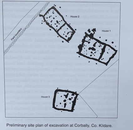
The Neolithic houses
Three Neolithic houses were uncovered in the south-western corner of a field. House 1 was centrally placed, 3m south-east of Structure 2 and 12m north-east of Structure 3. The remains of substantial foundation trenches were revealed in all three, as well as internal features including postholes, stake-holes, pits and hearths. External postholes and pits were also found. The three houses were constructed of post-and-plank walls.
A significant quantity of finds was recovered from the site, including sherds of Western Neolithic, round-bottomed, shouldered bowl and worked stone, including flint, chert, quartz, serpentine, saddle querns, hammerstones and broken fragments from polished stone axes.
House 1 was the largest of the three, measuring 11.07m x 6.73m. It was orientated north-west/south-east and was trapezoidal in plan, narrowing at the south-eastern end, where the doorway appears to have been. A large, continuous foundation trench divided this building into two chambers, and small, discontinuous trenches subdivided a third, smaller chamber.
The foundation trenches were very substantial, with postholes dotted at regular intervals along their length. Large, substantial internal postholes were present, which acted as roof supports, and two large, substantial hearths were centrally placed in the large chamber. There is the suggestion of two phases of activity within the house, as well as two phases of pre-house activity. Finds from this building were particularly rich. Only one radiocarbon date has been obtained to date, placing the house in the early fourth millennium BC, 3995 BC (5220+80 BP).
House 2 measured 10.77m x 5.29m and was again orientated north-west/south-east. This structure was slightly trapezoidal in plan, although this was not as obvious as was House 1. The narrower end of the trapezoid was at the south-east end, where the entrance appears to have been. A large, continuous foundation trench divided the house into two chambers.
The foundation trenches were substantial but slightly smaller than in House 1. Postholes were found in the foundation trenches. Pairs of internal postholes divided the house into aisles, which supported the roof. Several additional postholes appear to have been added during the lifetime of the house, presumably to augment the support provided by the original postholes. The house dates from the fourth millennium BC, 3685 BC (4910±80 BP).
House 3 was the smallest of the three buildings, measuring 7.37m x 6.45m. The structure was orientated north-west/south-east and was subrectangular in plan. Discontinuous foundation trenches subdivided the building into two chambers.
The foundation trenches were very substantial, with postholes dotted regularly along them. The house was divided into aisles by roof-supporting postholes. A large central hearth was present.
Discussion
These three structures were very similar to previously excavated Western Neolithic houses, and the radiocarbon dates indicate that they were constructed from the early to mid-fourth millennium BC. Peripheral archaeological activity was identified near the houses. Additional radiocarbon dates may cast further light on the contemporanity of this activity.
Peripheral archaeological activity
A subcircular pit lay less than 100m to the east-north-east of the Neolithic houses. Occasional tiny fragments of burnt bone, several burnt worked flints and a considerable amount of Beaker pottery were found in the pit. It measured 1.18m north-south by 1.25m and was 0.23m deep.
Archaeological deposits were also found c. 100m to the north-east of the Neolithic structures. A series of post- and stake-holes was revealed. Seven of the larger holes formed a rough arc c. 9m in circumference. Most of the smaller stake-holes were clustered together to the north-east, inside this arc. Further north-east of these deposits the ground had been disturbed by machine activity during soil-stripping, where it had been partially scarped away. Although many of the recorded features were very deeply cut and would have survived such disturbance, no trace of additional features, truncated or otherwise, was found. No finds were recovered from these deposits.
A pit lay 20m from the arc of postholes. This measured 4m north-south by 2.24m. It was oval in plan but very irregular. One piece of worked chert and one tiny sherd of decorated pottery, possibly Beaker ware, were found in it.
Approximately 235m to the north-east of the arc of postholes another small pit was found. It measured 1.44m north-south by 0.94m and was 0.54m deep. It contained a large quantity of early prehistoric pottery, possibly grooved ware, as well as worked stone. This feature was at the edge of the sand-pit. Similar features may lie adjacent to it outside the development area.
Brownstown townland
Further monitoring was carried out 800m south of the Neolithic houses, on the side of a gently rising hill, where limited soil-stripping was undertaken. During the course of this work three small pits, one posthole, and part of a large curvilinear feature were uncovered.
The pits were small, charcoal-rich features c. 0.6–0.8m in diameter. Cremated bone fragments were present in one of these, and a flint thumbnail scraper in another.
A section was put through the curvilinear feature to reveal a V-shaped ditch, 0.5m deep and 2m wide. The feature was traced over 23m. Both ends continued under the surrounding topsoil, suggesting that it is part of a larger circular enclosure. It probably represents the ploughed-out remains of an enclosure, with a shallow ditch surviving. It is likely that the remainder of the feature survives under the surrounding ploughsoil. The topsoil was backfilled after the section had been dug, and no development works were undertaken in this area.
These features appear to represent a phase of Bronze Age activity, not unusual given the large amount of previously recorded Bronze Age activity in the surrounding parts of north Kildare, as well as the presence of upstanding monuments.