1998:275 - GARRANEBANE, Kerry
County: Kerry
Site name: GARRANEBANE
Sites and Monuments Record No.: SMR 79:40
Licence number: 98E0522
Author: Laurence Dunne, Eachtra Archaeological Projects
Author/Organisation Address: 43 Ard Carraig, Tralee, Co. Kerry
Site type: Children
Period/Dating: Undetermined
ITM: E 446166m, N 578698m
Latitude, Longitude (decimal degrees): 51.939100, -10.237432
Monitoring and subsequent excavations were carried out to fulfil conditions of planning permission to construct a new VEC community college at Garranebane, Caherciveen. Work focused on the recorded monument classified as a ‘Children’s Burial Ground’. This monument had been virtually destroyed in the recent past, not least as a result of a concrete farmyard that covered much of the site and its environs, the continuous use of the monument as a dump and the density of growth on the site. The site lies on the seaward lower slopes of Bentee Mountain at the south-eastern limits of Caherciveen and commands extensive maritime views over the Valentia River estuary, Beginis and Valentia Islands and Doulus Head.
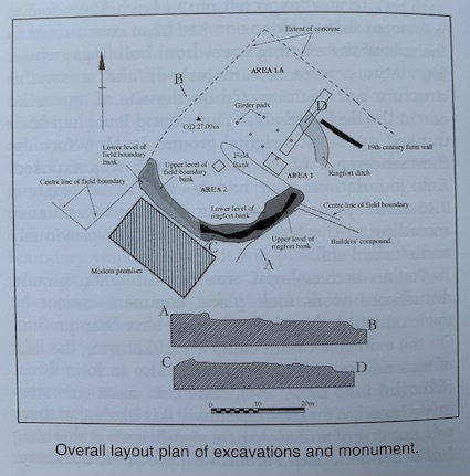
Children’s burial-grounds often occur associated with pre-existing archaeological monuments. This one appears to have the remains of a ringfort as its host monument. The site was so heavily overgrown and disturbed that an accurate survey was impossible before a clean up. The site was bounded to the west and east by field boundaries and to the south and south-west by the possible embanked remains of a ringfort. Measurements of the extant remains of the ringfort bank and from the 1st edition OS map showed that the host monument was circular in plan and c. 33m in internal diameter. No in situ grave-markers were found. A provisional 10m buffer zone was established around the proposed limits of the ceallúnach.
Monitoring of topsoil removal by machine throughout the main body of the site was carried out in October 1997. No artefacts, deposits or stratigraphy of an archaeological nature were identified.
Before any archaeological excavations it was necessary to remove the concrete that extended into the monument and beyond. This revealed that the north and north-east areas of the site had been heavily disturbed. However, in the south-east area of the site a subcircular arc of discoloured soil was revealed, possibly relating to the remains of an infilled ditch. An upper portion of a rotary quern was recovered here.
Two trenches were opened. Area 1 lay in the east of the site, orientated east-west; Area 2 lay in the north, where the concrete intruded on the monument.
Area 1 was subdivided into two cuttings, 1 and 1a. Cutting 1 was 4m north-south x 3m. Removal of the surface material revealed a complex of drainage channels and concrete girder pads. All earlier archaeological deposits had been destroyed, and no artefacts or stratigraphy of an archaeological nature were found.
Area 1a measured 2m north-south x 17m. It was positioned to reveal the possible remains of the host monument. Removal of modern rubble exposed a white, clayey natural. A grey, gravel natural was also exposed, into which a ditch 3.7m wide x 1.5m had been cut. This proved it to be the remains of the ringfort ditch, which had been deliberately backfilled and in more recent times utilised as a field drain. The ditch was subcircular in plan with a graduated break of slope. The sides were slightly concave in the east and steeply inclined towards the base. The break of base is concave, and the base is predominantly flat and U-shaped. No artefacts or other dating material were recovered from the ditch.
Area 2 measured 2m x 2m. Removal of topsoil exposed a stony shale layer. A small box-like setting of stones was encountered towards the south-west of the trench. Cleaning of this feature produced a number of small quartz nodules, supporting the interpretation that this may have been the remains of a child burial associated with the use of the monument as a ceallúnach. However, additional cleaning failed to produce any evidence of an associated grave-cut. The lack of burials encountered may be due to the nature of the division of the original monument by field boundaries and by the level of destruction.
Owing to the extent of the destruction and the amount of modern dump material no soil or charcoal samples were recovered. A number of organic samples were taken from the lower levels of the ditch fill, and specialist reports on these are pending.
A burial-ground clean-up took place concurrently with the excavations, and this enabled a detailed contour survey to be undertaken. Conservation work on the surviving remains of the monument will be carried out in the near future.