1998:262 - PORTUMNA CASTLE, Portumna, Galway
County: Galway
Site name: PORTUMNA CASTLE, Portumna
Sites and Monuments Record No.: SMR 127:18
Licence number: 95E0074
Author: Donald Murphy, Archaeological Consultancy Services Ltd.
Author/Organisation Address: 15 Trinity Street, Drogheda, Co. Louth
Site type: House - fortified house and Bawn
Period/Dating: Post Medieval (AD 1600-AD 1750)
ITM: E 585213m, N 704031m
Latitude, Longitude (decimal degrees): 53.086681, -8.220731
Another season of archaeological excavation took place at Portumna Castle during 1998. Archaeological investigation has been ongoing since 1995 (Excavations 1995, 37–8; Excavations 1996, 46; Excavations 1997, 77–8) alongside the restoration work by the National Monuments Section of Dúchas The Heritage Service.
Work in 1998 concentrated on the east side of the castle and on the south garden. The test-trenches excavated in the south garden confirmed the presence of bawn walls on both the east and west sides of the garden. In addition, an early ditch running north-south was uncovered midway across the garden. This ditch was backfilled before 1791 and probably represents an original 17th-century garden feature. A stone-lined ditch was uncovered further to the east, also running north-south. This feature is still visible along its full length and may be associated with one of the late drains exiting the south-east corner tower. The stone-lined ditch appears to take water away from a square, stone-lined pit in the wooded area to the south-east of the castle, which has not been investigated to date.
Further excavation took place beside the west wall of the medieval abbey in the area of what would have been the main entrance to the 17th-century castle. A rock-cut channel with stone-lined sides was exposed, 2.4m wide and 2m deep. It was stepped and sloped gently towards the east. The side walls were battered inwards, and the feature has the appearance of a stone-lined ditch. The feature is relatively early in date and clearly pre-dates the 17th-century avenue. It is possible therefore that the feature is medieval in date, and it may be part of the original boundary of the medieval abbey or associated medieval borough. The rock-cut channel ran east-west and returned to the south, just outside the west wall of the medieval abbey.
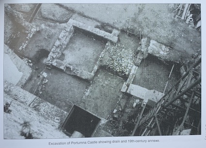
Archaeological excavation on the east side of the castle revealed the presence of a 19th-century annexe to the castle itself. This consisted of a rectangular building measuring 14.2m north-south by 7.1m. The building consisted of two rooms either side of a central stairwell leading from the courtyard on the east side of the castle down towards the central spine of the castle basement. This building is probably connected with the work done by the architect George Papworth in the early 1820s, shortly before the castle was destroyed by fire. This 19th-century annexe was originally three storeys high, as can clearly be seen from the plaster on the east wall of the castle.
In addition to this building a small 19th-century toilet block was uncovered immediately to the east of the north-east corner tower. This consisted of two cascades leading from ground level down to the main drain below, which runs through the castle basement and out under the south-west corner tower. The main conduit was also exposed just outside the north-east corner tower. It was of similar construction to the main conduit exposed below the castle basement itself and consisted of mortared stone walls with large lintels. It appears that this main conduit originally commenced just outside the north-east corner tower of the castle and that at some stage during the late 18th century a red brick culvert was constructed, which brought water from a well in the middle of the courtyard to the east into this main conduit. Restoration work is currently continuing on the castle.