1998:186 - DUBLIN: St. Mary's Church, Dublin
County: Dublin
Site name: DUBLIN: St. Mary's Church
Sites and Monuments Record No.: N/A
Licence number: 98E0236
Author: Tim Coughlan, c/o Margaret Gowen & Co. Ltd.
Author/Organisation Address: 2 Killiney View, Albert Road Lower, Glenageary, Co. Dublin
Site type: Church
Period/Dating: Post Medieval (AD 1600-AD 1750)
ITM: E 715389m, N 734549m
Latitude, Longitude (decimal degrees): 53.348561, -6.266922
St Mary’s Church of Ireland Church is reputedly one of the earliest galleried churches in Ireland and dates to the late 17th century. The building was in use until recently as a retail unit but retains many of its original features, including a decorated wooden organ casing dating to c. 1700 and an oak, break-fronted gallery. Other original features include staircases in the west tower and door casings. The church also has stone memorial plaques hanging on the walls. An appraisal of the building was carried out by Linzi Simpson in November 1997 (report lodged with Dublin Corporation and Dúchas The Heritage Service). The graveyard of the church lies on the southern side and now forms Wolfe Tone Park. The church is currently being redeveloped as a commercial unit.
A preliminary assessment was carried out in advance of the redevelopment. Four trenches were opened by mechanical excavator outside the north and west walls of the church. No archaeological deposits were identified in these trenches. A further six test-pits were opened by hand, one in each of the six underground crypts. Various remains were found within the crypts. These consisted, for the most part, of bits of timber coffins and disarticulated human remains but also included several articulated skeletons.
On the basis of the evidence revealed during the assessment an excavation was carried out in the crypts to record and remove the human remains and to clear the crypts to boulder clay levels.
All of the in situ remains were uncovered on an in situ soil level sealed by a deep deposit of loose soil. It is not clear why there was such a large amount of loose bone scattered throughout the crypts above the articulated remains, particularly in Crypt 4, as much of this bone was evident within the debris layer. Some of the bones were obviously disturbed by recent vandalism, as modern debris was associated with them.
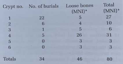
The table below shows the minimum number of individuals (MNI)* identified in the crypts of the church. The figures show substantial differences between individual crypts, with Crypt 1 containing the highest number of in situ remains and Crypt 4 containing the largest quantity of loose bones.
An additional assessment was requested by the developer in advance of a further planning application to extend the basement to include the area between the church and Wolfe Tone Park. The assessment took place between 11 and 14 December 1998 and was based on the excavation of five test-pits, opened by mechanical digger.
It is clear from the additional test-pits that the area between the railings that surround the church and its south wall was used to inter human remains, as several in situ human skeletons were found, orientated east-west. The main graveyard, however, lay to the south, in the area now known as Wolfe Tone Park. Most of the remains recorded during the assessment lay c. 1.8m below existing ground level and were sealed by an infilled brown soil with red brick inclusions. However, it is possible that there are graves surviving at a higher level in the areas not covered by the test-pits.