1998:062 - CORK: Adelaide Street/Kyle Street/Liberty Street/North Main Street/Paul Street/South Main Street, Cork
County: Cork
Site name: CORK: Adelaide Street/Kyle Street/Liberty Street/North Main Street/Paul Street/South Main Street
Sites and Monuments Record No.: N/A
Licence number: 96E0157
Author: Catryn Power, Cork Corporation
Author/Organisation Address: City Hall, Cork
Site type: Historic town
Period/Dating: Multi-period
ITM: E 566957m, N 572062m
Latitude, Longitude (decimal degrees): 51.899730, -8.480143
Excavation for the Cork Main Drainage Scheme took place within the archaeological zone of the medieval city from February until October 1998.
The medieval city walls were observed in three streets. Two portions were evident at the western end of Adelaide Street, one at the eastern end of Kyle Street and one at North Main Street. At North Main Street (the North Gate) a second wall, 4m thick and battered, was built against its south face. These walls were associated with horizontal timber beams and braces dating to the medieval period. Street metalling extended south from the city wall.
A 17th-century wooden barrel used as a cistern was recorded on Adelaide Street. It was stave built and bound by wooden hoops.
Medieval paving made of flat green sandstone and limestone was exposed for a length of 3.92m on Kyle Street. This was suggestive of the presence of a house. Six fragments of moulded Dundry stone, dating to the 13th/14th centuries, were found on Kyle Street. These originally came from at least one arch, possibly a church window.
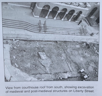
Two substantial structural walls on Liberty Street are probably medieval; one was 12m long and 1m wide, while the second had a footing. Lanes and houses were excavated on Liberty Street; these are depicted on John Rocque’s map of 1773. They were associated with North Devon Sgraffito wares, as well as a Cromwellian penny token from Clonmel. Excavations on Paul Street exposed walls of the original 18th-century buildings fronting the street.
A length of 3.26m of medieval street surface, laid on a foundation of small stones, was exposed on South Main Street. It ran in a north-south direction and was composed of flat red sandstone and limestone. Also on South Main Street two medieval timber structures were exposed. One of these is probably part of a fence or house. It consists of a row of wattling and a parallel row of upright timber planks associated with organic packing. The second structure consists of horizontal timbers associated with a row of posts. This may be the base of a boardwalk that is contiguous with an existing alleyway. An 18th/19th-century culvert built of red sandstone, running north-south, was recorded for the full length of trenching on South Main Street; 1.45m of its width was evident, while its height was recorded for 2.3m.