1996:326 - LEABEG, CASTLEARMSTRONG, CORNAFURRISH and CORRAHBEG, Offaly
County: Offaly
Site name: LEABEG, CASTLEARMSTRONG, CORNAFURRISH and CORRAHBEG
Sites and Monuments Record No.: N/A
Licence number: 96E0150
Author: Nora Bermingham, Irish Archaeological Wetland Unit, Department of Archaeology, University College Dublin
Author/Organisation Address: —
Site type: Road - class 1 togher
Period/Dating: Iron Age (800 BC-AD 339)
ITM: E 618982m, N 728762m
Latitude, Longitude (decimal degrees): 53.308798, -7.715178
In the summer of 1993 the IAWU carried out a survey of the Lemanaghan group of bogs located to the north-east of Ferbane, Co. Offaly. Bord na Mona have been extracting peat from this group of bogs in different stages since the 1950s. In Castletown Bog, situated in the eastern part of Lemanaghan, a single-plank walkway was identified close to the field surface where Bord na Mona had cutdrains through the site at regular intervals, causing extensive surface damage to the site. The site was traced for 384m and was oriented north/north-northeast/south/south-south-west. A dendrochronological sample yielded a date of AD 665±9 (Q9253).
As the IAWU were returning to the Lemanaghan area in 1996, the site was targeted for further investigation. Two short cuttings were opened along the length of the togher, which had been reduced in length by 47m between August 1993 and July 1996. The emphasis of this short excavation was on the recovery of a more extensive structural record and the retrieval of further dating samples.
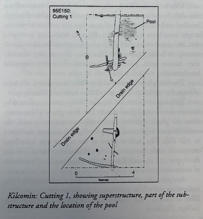
In Cutting 1 (9m x 4m) the superstructure was composed of two longitudinally laid planks. These timbers were radially and tangentially split oak planks and had minimum lengths of 3m and 3.5m. The surviving end of one of the planks sat directly on a single transverse, tangentially split oak plank, 1.09m long. At each end of the cutting a yew roundwood, transversely laid, was located. These measured between 2.9m and 3.3m in length. Elsewhere in the cutting the composition of the substructure was different owing to the presence of a shallow pool. A series of short roundwoods and split timbers had been closely set and retained by pegs on slightly higher and drier ground just to one edge of the pool. These formed a small platform over which the upper timber was placed. The pool was filled in with strips of oak bark and large amounts of oak wood-chips. The pegs ranged in length from 0.8m to 1.4m.
An oak plank with a surviving length of 4.4m formed the superstructure of the site in Cutting 2. This timber was c. 0.3m wide and 0.1m thick. An empty mortice survived close to the intact end of the plank. The substructure at this part of the site was very simple and consisted of two transverse oak planks, located towards either end of the upper timber, and occasional wood-chips. Two longitudinal roundwoods with a peg on one side were also uncovered, but it could not be determined whether they were superstructural or substructural elements.
Further variation in site construction was recorded at fifteen other locations along the line of the site. The record was restricted to what was visible either on the field surface or in the drain face. Single longitudinal planks were the most common form of superstructure. There was one instance of two longitudinal planks lying parallel to one another. At three sightings a series of parallel roundwoods, ranging in number from two to seven, formed the superstructure. Substructural elements, which were not visible to the same extent as the upper elements, were largely transverse roundwoods.
Two further dendrochronological dates were returned for the site: AD 667±9 (Q9280) and AD 684±9 (Q9279). The three dates from the site can be considered to be contemporary and demonstrate that the site was of single-phase construction.
This mid-seventh-century togher is still in the process of being destroyed. The site requires protection and/or more extensive investigation.