1996:210 - KILKENNY: 68/69 John Street, Kilkenny
County: Kilkenny
Site name: KILKENNY: 68/69 John Street
Sites and Monuments Record No.: N/A
Licence number: 96E0131
Author: Edmond O'Donovan for Margaret Gowen and Co. Ltd
Author/Organisation Address: Rath House, Ferndale Rd. Rathmichael, Co. Dublin
Site type: Watercourse and Town defences
Period/Dating: Medieval (AD 400-AD 1600)
ITM: E 650839m, N 656043m
Latitude, Longitude (decimal degrees): 52.653199, -7.248617
An archaeological test excavation was carried out on a site at the rear of John Street and Maudlin Street, Kilkenny, in June 1996. The site lies on the eastern bank of the River Nore adjacent to and immediately outside the medieval suburb of St John. The suburb is an extension of the main medieval town (Hightown) on the western side of the Nore. The suburb grew up around St John’s Priory, which moved to its present location in 1325. References to town walling around the suburb occur in the early sixteenth century, when there are references to a stone and lime wall, and a turret in 1570 (A. Thomas, The walled towns of Ireland (1992)). When Cromwell besieged Kilkenny in 1650 he described the siege thus: ‘Having possessed the Irishtown, and there being another walled town on the other side of the river [St John’s], eight companies of foot were sent over to possess that’.
Thirteen trial-trenches were opened by mechanical excavator in order to assess the archaeological nature of the site and to evaluate the presence of mural defences outside the town wall. The north-western site boundary wall is located along the supposed line of the town wall of Kilkenny (Thomas, op. cit.). From detailed inspection of the wall and the results of the trial-trenching, it was possible to identify the remains of the town wall with evidence of breaches and repair in places.
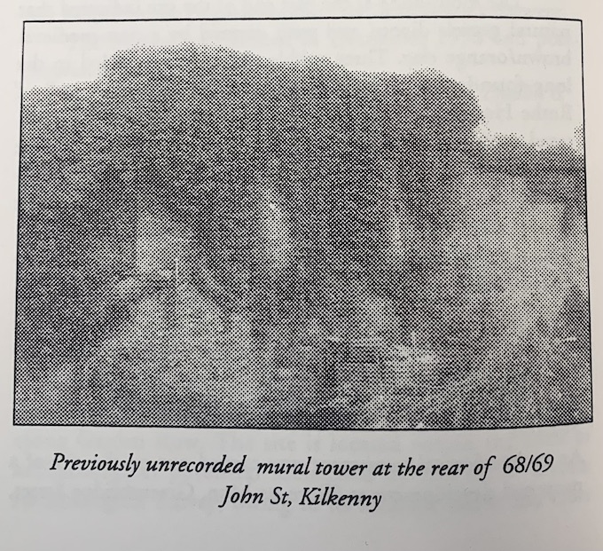
The stretch of the town wall on the site is 78m long, constructed of limestone and standing between 2.6m and 3m above ground level. The wall foundations extend to a depth of 3m below ground level, with a significant base batter identified in the trial-trenches. An internal mural tower located midway along the wall portion rises to 5.5m above ground level and is 7.4m wide. Originally, the tower may have been rectangular, with its south wall backing onto the town wall. All the internal walls are gone above ground level, though the south wall of the tower has dressed quoins and scars from where the tower joined the inside of the town wall. Two arrow-loops are visible 2.2m above ground level, measuring 0.lm wide and 0.8m high, splayed internally. The tower appears to be contemporary with the town wall. A later red brick and stone wall was built on top of the town wall abutting the tower. Many alterations and repairs are evident along the wall, particularly at its western end.
A watercourse which may have served as a moat outside the town wall was located in two trenches. A mill-race ran through the line of the wall, bisecting the suburb of St John’s. No further archaeological deposits were revealed in any of the test-trenches on site. However, these trenches did reveal the nature of the topography outside the town wall in the medieval period. The southern end of the site consisted of wet ground, which is likely to have been waterlogged during the winter months; this was revealed from soil profiles in Trenches 1, 3–8 and 10–13. At the northern end of the site the profile in Trenches 2 and 9 revealed boulder clay as the basal deposit, which is likely to have remained dryer. The nature of the underlying soil conditions can be explained by the gentle slope on the site from north to south. It is possible to speculate that Maudlin Street follows this break in slope, reflecting the edge of the old floodplain line of the river. The original road to Dublin extends along this topographic feature.
There was little evidence for archaeological deposits in the trenches opened apart from the watercourse identified, which appears to lead to the mill-race illustrated in Rocque’s map. This was not disturbed during the development works on the site and no other archaeological features were noted during monitoring of the construction phase.