1996:418 - TATTYREAGH, CO. CAVAN, Cavan
County: Cavan
Site name: TATTYREAGH, CO. CAVAN
Sites and Monuments Record No.: SMR CV028-048
Licence number: E1041
Author: ERIN GIBBONS
Author/Organisation Address: —
Site type: Early Bronze Age graves
Period/Dating: —
ITM: E 667192m, N 802207m
Latitude, Longitude (decimal degrees): 53.964794, -6.976006
Introduction
In April 1996 a short cist was discovered during the removal of a stone cairn near Bailieborough, Co. Cavan. The cairn was being removed by a mechanical digger and it is estimated that approximately 100 tonnes of stone had been removed before the clearance stopped. The digger-driver stopped only after his machine lifted a large stone, the capstone, covering a short cist. The site was reported to Dominic Egan, curator of Cavan County Museum, who informed the NMI. A rescue excavation was undertaken by Erin Gibbons on behalf of the Museum. This report is based on Gibbons’s account of the site.
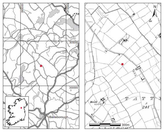
Location (Fig. 3.15)
The site was in the townland of Tattyreagh, near Bailieborough, east Co. Cavan.28 It was in the southern corner of a pasture located on top of a drumlin ridge at an altitude of approximately 200m above sea level. Clear views of the local topography were visible on all sides, in particular of the Cuilcagh Mountains to the north-west, County Monaghan to the north, the Cooley hills to the east and the Loughcrew hills, Co. Meath, to the south.
Description of site
The site consisted of the badly damaged remains of a stone cairn, which covered an estimated area of 9m by 8.5m before the recent damage occurred (Fig. 3.16). It survived to an average height of 1.4m above ground level and was primarily stone-built, with some inclusions of earth.
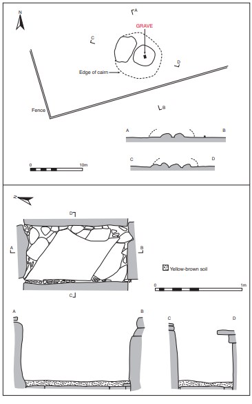
The cairn was truncated by a 0.5m-wide cutting by the digger. The cist was situated approximately 1.5m east of the centre of the cairn. No other cists were visible although a number of regular rectangular slabs were scattered loose around the site, suggesting the possible presence of others. The cist had been built on the old ground surface and the cairn built up around it.
Description of grave
The cist was rectangular in plan, with its long axis aligned north-west/south-east (Fig. 3.16). It measured 1.17m long by 0.64m wide by 0.75m high internally. It was constructed of four main edge-set slabs. The side stones were flat slabs and the end stones were irregularly shaped upright boulders. The structure was heightened at the east and west by two courses of stones laid flat. These flat stones lay almost flush with the side stones at the west, whereas at the east they projected inwards to suggest a partial corbelling effect. This feature may have been exaggerated by pressure inwards caused by the bulldozer. The lower course in particular appeared to be in a primary position. The lower stone projected inwards for an average of 4cm, while the upper course projected inwards for a distance of 16cm. It would appear that the eastern side originally contained at least one more stone course to make it level with the west face. The floor of the cist was paved with one main rhombus-shaped slab around which were placed smaller stones so that the floor was completely paved. The large capstone, now displaced, measured approximately 2m in length and would have amply covered the cist.
The cist contained some fragments of unburnt skull of an adult individual (1996:229). No accompanying artefacts were found. The remains were found in a shallow deposit of yellowbrown soil containing two small quartz fragments. The bone was concentrated in a 15cm area in the south-western quadrant of the cist and was present throughout the depth of the layer.29
A deposit of loose soil (c. 3cm thick) overlay this and was thought to have fallen in from the surrounding cairn after the cist was opened. When this soil was removed in the south-eastern quadrant a circular lens of dark soil (8cm by 8cm) was noted. It was initially thought that this was a possible post-hole feature, but it was such a thin spread that it was probably soil intrusion from above. According to the excavator, the cist chamber was probably interfered with in the historic past. In local tradition it was believed that there was a small room in the cairn, and there were hints to the effect that arms were stored in the cist in the early 1920s.
Comment
The human remains from this site have not been dated. No grave-goods were recovered but the form of the cist, although not exceptionally massive, and its construction on the old ground level may suggest a Neolithic rather than an early Bronze Age date for the site. There is insufficient evidence, however, to determine a date for this site. Two small quartz fragments were also recorded in the area of the cist where the human remains were found. The smaller fragment is white while the bigger one is dark. It is not clear whether these were deliberate inclusions with the burial or were due to the disturbance on the site.
HUMAN REMAINS
LAUREEN BUCKLEY
Introduction
Previous disturbance of the skeleton (1996:229) may account for the fact that very little bone was recovered and that the bone that was present was very decayed. Disturbance and reburial of a skeleton greatly hasten the decay process.
Description of bone
Although there is mention in the site report of the recovery of a further seven bone fragments from the grave, the only bone available for inspection consisted of the three skull fragments originally removed by a local historian.
Two of the fragments, approximately 3cm in length, were from one piece of parietal bone of the skull; the other, smaller fragment was probably also from a parietal bone. The maximum thickness of the bone was 7mm and it could have come from an adult skull.
28. Parish of Knockbride, barony of Clankee. SMR CV028-048——. IGR 267256 302196.
29. Three skull fragments, which were retrieved earlier, were also found in this context.