1995:206 - DUNDALK: Clanbrassil St., Louth
County: Louth
Site name: DUNDALK: Clanbrassil St.
Sites and Monuments Record No.: N/A
Licence number: 95E0168
Author: Cia McConway, ADS Ltd
Author/Organisation Address: Power House, Pigeon House Harbour, Dublin 4
Site type: Historic town
Period/Dating: Late Medieval (AD 1100-AD 1599)
ITM: E 704713m, N 807339m
Latitude, Longitude (decimal degrees): 54.004653, -6.402646
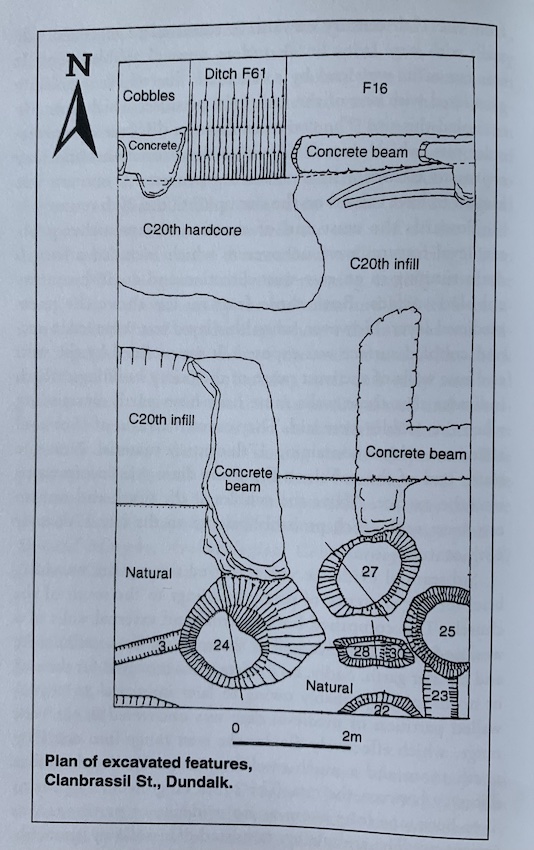
The site is situated behind the existing Ulster Bank building at the corner of Clanbrassil St. and Jocelyn St., Dundalk, Co. Louth. The primary concern of the excavation was to determine the location and nature of the town’s medieval defensive ditch, as indicated by Paul Gosling and later by the Medieval Urban Survey. Through a combination of the study of documentary sources, 17th-century maps and the town’s topography, it had been convincingly postulated that the town’s defensive ditch would run east-west across the site, cutting across the southern end of Clanbrassil St.
A small trench 6m x 11m was opened up, with the concrete and overburden being mechanically removed. A large central area of the trench had been so badly disturbed with old concrete ground beams that no intact stratigraphy survived here. As a result, the trench was effectively split into two areas with no direct stratigraphic relationship surviving between the two. A narrow strip, 2m x 6m, was excavated at the far north of the trench, and a larger, 4m x 6m, excavated along the south of the trench. These areas had not been so severely truncated by later activity and were hand-excavated.
Initial hand-excavation along the north of the trench revealed a cobbled surface extending east-west. A small portion of a drystone wall existed north-south and was butted against by the cobbles. Below this was a grey/brown clay with charcoal flecks and large stones. Both medieval and post-medieval pottery were retrieved from this layer, which formed the sealing layer to the upper fills of the ditch.
The uppermost fill of the ditch proper, F16, produced a sherd of Drogheda-type pottery, dating from the late 13th/early 14th century. Such was the size of the ditch, and the confined space to work within it, that it soon became impractical to excavate by hand and so a section 1.6m wide was mechanically cut through and the section face recorded. As it survived, the ditch was 1.7m in depth and almost 2m wide (half-section). It had cut through the hard yellow boulder clay, into the underlying soft blue/grey silty clay, but not into the gravel known to underlie this from elsewhere on the site.
The outer edge of the fosse had a distinct step in its profile and had evidently suffered from slumping, causing the outer ditch edge to fall in on itself in the waterlogged conditions. The fosse fills were generally blue/grey silty clays and brown/purple organic mix. There was no evidence for an old turf-line along the base of the fosse, suggesting that it was not left to stand open for any length of time. As evidenced by the silty nature of the fills, it is most likely that the fosse was continually waterlogged. Three possible recuts were observed in section, indicating an attempt to reinstate the line of the town defences at a later date.
Two gullies were uncovered at the south of the trench, under a sealing clay free of red brick, and both cut through into the natural and across earlier pits. F3 ran east-west across the site for 3.6m and had cut through the upper fill of F24. It had a max. width of 0.4m and max. depth of 0.18m. A mix of medieval and post-medieval pottery was recovered from its fill.
F23 ran north-south in the south-east corner of the trench. It cut through the upper fill of pit F25. It had a max. width of 0.6m and a max. depth of 0.22m. Medieval local cooking ware was recovered from the fill. There was no direct stratigraphic relationship between the two gullies other than that they both underlay the sealing clay.
A total of six pits were excavated in the southern area of the trench, all cut through natural and underlay the sealing clay.
F22 was a straight-sided pit, excavated in half-section along the southern baulk of the trench. It had a depth of 0.6m and a width of 1.48m and was filled with a dark grey/brown clay with crushed shell, bone and charcoal. Sherds of medieval local cooking ware were recovered from the fill.
F28 and F30 were two small adjoining pits with a total length of 1.36m and max. width of 0.48m; F28, the deeper of the two, had a depth of 0.34m. F28 cut through the upper fill of F24, one of the large pits, while F30 was in turn cut by F25, another large pit at the south-east of the trench. A sherd of medieval local cooking ware was recovered from the fill of F28.
Three very large medieval pits, F24, 25 and 27, were uncovered in the southern area of the trench. F27 cut the upper fill of F25 and F24. There was no conclusive direct relationship between F24 and F25.
F24 measured 2.56m x 1.68m and was regularly shaped, with a gradually sloped edge along the eastern side and steeply cut elsewhere. The base was quite wide and flat. In general the fills were almost totally stone-free and were of a high organic content, producing a lot of shell and animal bone. A possible recut could be traced within the ditch fills, suggesting that the pit was reused at a later date. Lining this recut pit was a series of wooden stakes, crudely worked but still indicating that the pit had been partially lined with wood for a time. A sherd of medieval local cooking ware and a sherd of Bristol pottery were recovered from a fill of the recut pit.
F25 was excavated in a little over half-section along the east baulk. As excavated it had a max. width of 1.52m and a depth of 1.95m. The pit was steeply sided with a narrow flat base. It had been backfilled with a series of clays and organic rich clays. Retrieved from the very basal fill was a fractured but almost complete jug of Cheshire-type pottery. This pottery dates from the late 13th century to the 14th century and is also known from sites in Carickfergus, Dublin and Drogheda. A lot of animal bone was recovered from the fills, including an ox skull and jaws. Analysis of the bone has shown numerous butchering marks. There is evidence that the pit was recut/cleaned out at least twice again, suggesting continuous activity in this area.
F27, a large oval pit, was equidistant between F24 and F25. It measured 1.84m x 1.36m with steep sides and a narrow, flat base. The base of the pit again just breached the natural gravels. The primary fills of the pit were a heavy wet blue clay suggesting waterlogged conditions, which contrasted with the upper, drier, organic fills. The pit possibly underwent one recut and a sherd of medieval temper-free ware was recovered from the basal fill of the secondary cut.
The evidence from the excavation has at last pinpointed a small area of the town fosse running across the southern limit of Clanbrassil St. Supplementary evidence of medieval activity is provided by the large rubbish pits, indicative of activity and perhaps occupation in the area immediately outside the town fosse. This activity may have been a direct result of the nearby location of the meat market, an unsociable and noxious trade that was often confined to the peripheral areas of the town. The large pits contained quite a number of animal skulls and bones, by-products of slaughtering, which must have taken place in the immediate vicinity.
While there was no direct stratigraphic relationship between the town fosse and the pits, it would seem more likely that the pits post-dated the fosse. Evidence from English medieval towns shows quite clearly that while unsociable trades were carried out in peripheral areas of the town, they still took place within the protection of the town’s wall. As the town’s defences were paid for by all the townsfolk, it is highly unlikely that the fosse would have stopped short of the meat market, omitting the extreme southern area of the town. It seems more likely that the town fosse had already existed and that the pits represent an expansion of the town to the south. As the pits produced pottery of late 13th- to 14th-century date and it is postulated that the pits post-date the fosse, then a date sometime before the late 13th century can be assigned to the fosse.