1995:059 - DUBLIN: Back Lane/Lamb Alley, Dublin
County: Dublin
Site name: DUBLIN: Back Lane/Lamb Alley
Sites and Monuments Record No.: N/A
Licence number: 95E0248
Author: Margaret Gowen
Author/Organisation Address: Rath House, Ferndale Rd, Rathmichael, Co. Dublin
Site type: Town defences and Habitation site
Period/Dating: Late Medieval (AD 1100-AD 1599)
ITM: E 714826m, N 733826m
Latitude, Longitude (decimal degrees): 53.342192, -6.275633
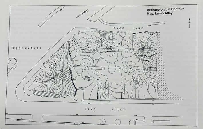
An archaeological site survey was undertaken in advance of a proposed development on the large vacant site at Back Lane/Lamb Alley, Dublin 8, to map the surface of the archaeological deposit. Preliminary assessment had been carried out by Andy Halpin in 1991 when three test-trenches were excavated to boulder clay (Excavations 1991, 12–13). This assessment indicated the possibility that ‘high spots’ of archaeology might exist on the site. The significant rise in the present ground level on the site was noted and was later defined as a variation of over 1m from south-west to north-west.
Prior to excavation of the survey trenches the site was contour-surveyed to get an accurate picture of the present site surface using a ‘total station’ instrument. A total of sixteen trenches were then opened to coincide with the location of the proposed ground beams in the original foundation layout for the site. Two long trenches were opened across the long axis of the site. Seven trenches were opened at right angles to these, three towards the street frontage at Back Lane and four along the Lamb Alley side, one of which was deepened in a pit through archaeological deposits to establish if remains of the city wall underlie the standing facade along Lamb Alley which is to be retained. Six further short trenches were opened at the northern end of the site.
Preliminary excavations along the base of the existing boundary wall of Lamb Alley suggest that the remains of the city wall lie beneath it, following the line of the road. A yellow/orange redeposited boulder clay, located only on the southern side of the site, lies at a relatively high level. This is possibly the remains of a defensive bank. The clay appeared to abut the face of the wall. It appears likely that the wall is actually cut through the clay, with the wall replacing the bank. This clay does not appear on the rest of the site.
The top of the truncated ‘city wall’ was exposed in Trench 3, with the line of it possibly suggested in Trench 1 by foundation trench fill. The stretch of the above-ground ‘city wall’ was also tested, exposing a deep rubble layer. The yellow/orange redeposited boulder clay also abutted this wall at the lowest exposed level.
The archaeological testing revealed that there were no 18th-century cellars on the site apart from a small area confined to the south-west corner. As a result, the upper archaeological layers throughout the remainder of the site were 17th/18th-century in date. The site, therefore, appears to have been an unbroken line of archaeological deposits dating from its earliest levels through to the 17th/18th century.
The results of the ‘total station’ survey revealed that most of the site area has extremely high levels of archaeological deposits composed of clays with a very low organic content at the upper levels. The extreme conflict of levels between the formation levels and the surviving archaeological deposits posed an intractable problem for the original design concept. The whole building has had to be raised and an innovative engineering approach designed to avoid perforation of these important upper deposits by the substructure of the building, apart from the piles.