1994:229 - WEXFORD, Wexford
County: Wexford
Site name: WEXFORD
Sites and Monuments Record No.: N/A
Licence number: 93E0190
Author: Joanna Wren
Author/Organisation Address: The Milepost, Slieverue, Co. Kilkenny, for ADS Ltd
Site type: Historic town
Period/Dating: Multi-period
ITM: E 704727m, N 621950m
Latitude, Longitude (decimal degrees): 52.339151, -6.463129
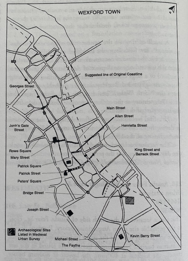
From November 1993 to December 1994 the writer was involved in archaeological work on the Main Drainage Scheme, in fourteen areas in Wexford Town. These were King St., Barrack St., Joseph St., Michael St., Kevin Barry St., St. Patrick’s Sq., Peter St., Bride St., Johns’ Gate St., Mary St., Upper Georges St. and Rowe St. King St. and Barrack St. are at the south end of the town. They are inside the area of the supposed pre-Norman settlement. The line for the drainage work crossed defences both in these streets and in Peter St., Johns’ Gate St., Bride St., Mary St., Upper George’s St. and Rowe St. Five of these streets, Barrack St., Peter St., John’s Gate St., Bride St., and Mary St. are named as the sites of gates on the town wall. Patrick’s Sq., Peters’ Sq., Michael St., Kevin Barry St., and Joseph St. are all close to the sites of medieval churches and graveyards.
King St.
A post-medieval culvert ran north-east/south-west on the line of the town wall. The north-east wall of the culvert had the remains of an earlier stone wall built into it. The wall was constructed of rough dressed shale quartz and sandstone bonded with cream mortar. It was 1.4m wide and a face survived to the east. No dateable finds were recovered from the material deposited against the wall. It is therefore difficult to suggest a date for it. It was, however, of similar construction and width to surviving stretches of the medieval town wall and ran close to its estimated line. It is therefore likely that it originally formed part of the wall.
Forty metres north-east the remains of clay floors and occupation debris were revealed in the section of the drainage trench. These were limited to one stretch of section c. 8m long east-west. On either side of this stretch the section face contained estuarine silt and organic material at the same level. The floors seem to be from a building or buildings located c. 30–40m inside the town wall. Such buildings probably stood alone rather than forming part of a run of plots fronting onto a precursor of King St.
Barrack St.
This street runs along the west side of the modern Military Barracks. The Barracks may be the location of the original Pre-Norman settlement or ‘longphort’. The line for the drainage work here extended across the town defences and therefore there was an archaeological excavation. Work uncovered a bank and fosse running north-east/south-west. The height of the bank to the base of the fosse was 1.26m. This is too small to have functioned as a town defence and was probably part of an enclosure for St Olaf’s church, a pre-Norman foundation reputedly located in this area. The fosse was backfilled with brown silts containing 12th-century pottery.
Patrick’s Sq.
Test excavations here uncovered the remains of some type of sunken feature, which may be a ditch. This was 2m north of St Patrick’s parish church and graveyard. It measured 14.5m north-south with an eastern return at its southern end. The trench was backfilled with organic occupation debris containing 13th-century pottery.
Peter St.
Test excavations here revealed the remains of a foundation trench for the town wall. The trench measured 1.6m wide and was filled with loose undressed shale in a grey silt. It was cut into the natural boulder clay. The trench was cut through to the north by modern service trenches and no sign of a gate survived.
Test excavation work and monitoring were also carried out in Joseph St., Michael St., Kevin Barry St., Bride St., John’s Gate St., Mary St., Upper George’s St, and Rowe St.
No archaeological remains were uncovered.