1994:188 - THE DESERTED VILLAGE, Slievemore (Toir), Achill Island, Mayo
County: Mayo
Site name: THE DESERTED VILLAGE, Slievemore (Toir), Achill Island
Sites and Monuments Record No.: SMR 42 : 1403
Licence number: 91E0047
Author: Theresa McDonald, Achill Archaeological Summer School
Author/Organisation Address: St O'Hara's Hill, Tullamore, Co. Offaly
Site type: Settlement cluster
Period/Dating: Multi-period
ITM: E 462980m, N 807511m
Latitude, Longitude (decimal degrees): 53.998649, -10.089930
The fourth season of survey and excavation at the Deserted Village (Toir) Slievemore continued over a six-week period in July and August, 1994.
The work schedule for the 1994 season included the completion of the instrument survey in the village of Toir and extension of the excavation at House No. 36 and in the adjoining garden.
The Survey
An area of c. 1500 sq m was surveyed and included four houses, Nos 5, 7, 8 and 9. The houses in this area which do not appear on the 1st edition map of 1837 are widely separated and have a wide range of associated enclosures of varying sizes, differing from the settlement pattern further east in Toir where a majority of these enclosures tend to be located close to the valley bottom south of the present roadway. House No. 5 consists of three units and therefore is classed as a cottage. Construction details as well as size indicate that the southern unit was probably an outhouse or byre. Surprisingly, despite its large size and relatively good preservation there was no evidence of a window/s in this house. House No. 7 is a small single-roomed cabin abutted by a stone wall which extends southwards to enclose a large field recently reclaimed. House No. 8, also a single-roomed cabin, contains a bed recess in the north-west corner. Comparison of this house with houses dating to pre-1837 indicates almost identical construction features. House No. 9 is a two-roomed structure with a fireplace on the northern, dividing wall. While construction details suggest that the northern room was a later addition, the presence of the only existing window in this room tends to suggest otherwise. A substantial buttress over 1m high abuts the southern gable and like similar examples elsewhere appears to serve no useful purpose. Set into an adjacent garden wall north-east of this house is a small oval structure which has been variously depicted as a well or clochán. It resembles a small oval shaped cist lined with orthostats on top of which are corbels supporting the roof. In so far as it can be determined the orientation is east-west. The interior is quite dry and there is no sign of water or dampness. Other enigmatic structures in Toir suggest that megalithic structures which are today confined to the south-eastern slopes of Slievemore may have, prior to the construction of the Deserted Village, extended much further westwards.
The Excavation
The 1994 season’s work commenced with de-turfing the remainder of the terrace immediately south of House No. 36 and a clean-up of Layer 3 west of the house. One of the more interesting features was the remains of a stone wall c. 0.5m high set at a lower level and at a different alignment to the house which may form part of an earlier structure or alternatively a drainage wall. Further excavation in 1995 will clarify the exact nature of this structure. The path emanating from the west (Excavations 1992, 50 and 1993, 63) and continuing in an easterly direction south of House No. 36 was shown upon further excavation to turn sharply southwards immediately east of House No. 37 on the south. The terrace appears to consist of various deposits, the result perhaps of excavated material taken from the nearby oval depression which forms the manure pit east of the house.
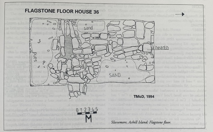
The interior of the house was hand excavated and ultimately revealed a very impressive flagstone floor (see Figure) with various demarcation areas for both humans and animals clearly defined. This house originally contained a loft which would have served as a sleeping area as well as storage of winter fodder.
The Garden
Cutting C in the garden was again extended this year and a trench was dug at right angles from this cutting to the north-east corner of the house at an elevation some 1.5m higher than outside ground level. The cutting in the area immediately abutting the eastern wall of the house revealed how the builders of the house had apparently decided on the approximate size of the house to be constructed, dug out the foundations but seemingly finding that the desired width was exceeded by c. 0.5m, back-filled the area between the garden and the house with topsoil which contrasted sharply with the sandy bottom layer, both of which were clearly defined in the cutting. Indeed, the straight edge of an implement, more than likely a spade, could be seen clearly in the cutting. Planning of the south and north sides of the trench revealed undulations which have been interpreted as the profiles of lazy beds. This seems to indicate that cultivation was practised in this area prior to the construction of the house.
Finds
Finds consisted of a dog cranium, various pieces of broken 19th-century flatware and glass, the remains of iron objects, pieces of wood and fragments of thatching rope. The finds have been marked and catalogued and will be on display at the Folk Life Centre, Dooagh.
Documentary research of this post-medieval deserted village continues hand-in-hand with the survey and excavation and will eventually be published in monograph form.
This project is due to continue in 1995.