1994:160 - KING JOHN'S CASTLE, Limerick, Limerick
County: Limerick
Site name: KING JOHN'S CASTLE, Limerick
Sites and Monuments Record No.: N/A
Licence number: 93E0082
Author: Kenneth Wiggins
Author/Organisation Address: 13 Aisling Heights, Raheen, Co. Limerick
Site type: Castle - Anglo-Norman masonry castle
Period/Dating: Multi-period
ITM: E 557659m, N 657743m
Latitude, Longitude (decimal degrees): 52.669209, -8.625997
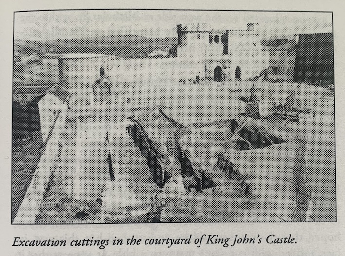
The second season of the Shannon Heritage Ltd./FÁS research excavation in the courtyard of the castle was contracted for a 26-week period beginning on May 2, 1994, onto which was added on 11-week extension up to January 13, 1995.
To start with, excavation proceeded jointly in an extension to Cutting 1 on the northern side of the yard, and in Cutting 2 to the west. In the second part of the excavation, work in Cutting 1 was temporarily suspended in order to concentrate on a large extension opened along the eastern side of Cutting 2.
The extension to Cutting 1 was situated at its western side, and measured 10m (east-west) by 7m (north-south). The reason for enlarging the cutting this way was to reveal the full ground plan of a semi-underground Hiberno-Norse dwelling (SFS 4) partially excavated during the first season. SFS 4 consisted of the remains of a single room measuring 3m by 3.2m which had been erected inside an oblong construction pit measuring 4.8m by 5.6m. All of the structure’s below-ground timberwork had been left in situ when it was abandoned, but this material survived only in a heavily decayed state. The floor of the building had been established around 1.3m below the contemporary ground level. The house was backfilled with sterile redeposited clay. The construction pit cut into the inner edge of a bank of upcast clay extending on an east-west alignment along the northern side of the cutting. This feature was part of a ringwork constructed on the site by the Anglo-Normans in the 1170s. This relationship dates SFS 4 to the last quarter of the 12th century, before construction of the stone castle commenced early the following century.
A short distance to the west, part of the eastern side of another sunken house was excavated (SFS 5). This survived at boulder clay level only, and was securely sealed below the tapering Anglo-Norman bank. It may be possible to extend Cutting 1 a second time in the course of 1995 in order to reveal the full outline of this structure.
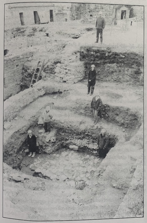
The main discovery during 1993 in Cutting 2 was of the well-preserved remains of the great hall of the castle, gradually revealed by mechanical removal of heavy 19th-century rubble infill. This year, the hand-excavation of archaeological deposits associated with the building commenced. Three sub-cuttings, 2A-C, were opened in the interior of the hall, abutting the western curtain wall. The hall had been floored in the medieval period at a depth of around 5m below the present-day courtyard level. The reasons for digging here were to evaluate the nature of deposits underlying the medieval floor, to identify pre-castle stratigraphy, and if possible to reach the base of the western curtain wall itself. However, the excavation here was hampered by the presence of the spine wall standing in the middle of the hall, imposing strict limits to the size and depth of these sub-cuttings. The top of the foundation of the western curtain wall was touched at a depth of 8.7m below the castle-yard, and this was as far as manual excavation could safely be taken. It was found that the lower 3m or so of the free-standing wall had been backfilled with sterile clay and stone. The hall itself had been added onto the western curtain wall in the course of the 13th century, its foundations set on top of this great thickness of backfilled clay.
The hall was enclosed on the southern end and along the eastern side by a corridor extending out from the watergate located at the foot of the western curtain wall. Excavation in the southern length of the corridor revealed an almost completely intact 18th-century surface of limestone steps and cobblestones, which had been left undisturbed. This part of the corridor is retained on the courtyard side by a sloping wall of 17th-century date, with a maximum surviving height of 3.4m.
In contrast, the eastern line of the corridor did not contain any post-medieval flooring or masonry. It is defined to the east by an original wall which may be dated from a documentary source to the year 1297. This has a maximum surviving height of 1.7m. An area of in situ paving of similar date survived in the corridor, next to the blocked south-eastern door of the hall. The stone formation was underpinned by a thick infill of stony clay containing hundreds of oyster shells.
Excavation has revealed that the eastern extent of the corridor was backfilled and sealed in the 1660s, when the 1297 wall was partially demolished. However, the southern half of the corridor was maintained in use up to the early 19th century.
The main excavation this season was in an extension established to the east of the hall and corridor, Cutting 2D. This measured 11m (north-south) by 8m (east-west). The purpose behind this was to look for evidence of the large Anglo-Norman ringwork ditch, first discovered during the castle excavations in 1990/1 (Excavations 1990, 43–4) which appeared to bisect the courtyard of the castle on an east-west alignment. In this way the relationship between the primary earthern version of the castle and its developed stone successor could be better understood.
The location of Cutting 2D coincided with the western side of the main square of the army barracks established in 1750, and the massive limestone foundations of this structure were the most prominent features of the cutting until several of them were dismantled and cleared. The insertion of this masonry in the 18th century extensively disturbed the floor level of a building or enclosure dating to the 1690s. The flooring was composed of brick, and it was associated with a relatively lightweight limestone foundation supporting the base of a slender brick wall. The floor was placed over a spread of 17th-century infill stratified on a layer of medieval topsoil. However, the vast bulk of the material excavated from 2D was in the main sterile redeposited clay, up to 3m in total thickness, backfilled in the 13th century to level-up the yard of the castle. Excavation in this cutting will be completed in 1995. To date, stratified deposits have been removed to a depth of 4.5m below the modern yard level, but no 12th-century material has been identified, and there is as yet no direct evidence for the Anglo-Norman ditch or any infills relating to it.
Towards the close of the second season, systematic work by stonemasons on the cleaning and repair of the fabric of the great hall was commenced.