1994:065 - DUBLIN: Kinlay House, Fishamble St, Dublin
County: Dublin
Site name: DUBLIN: Kinlay House, Fishamble St
Sites and Monuments Record No.: N/A
Licence number: 94E0102
Author: Margaret Gowen
Author/Organisation Address: Rath House, Ferndale Rd, Rathmichael, Co. Dublin
Site type: Excavation - miscellaneous
Period/Dating: Multi-period
ITM: E 715201m, N 734028m
Latitude, Longitude (decimal degrees): 53.343925, -6.269933
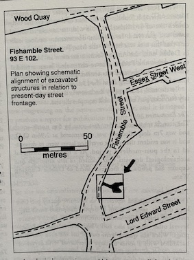
An archaeological watching brief was maintained on site clearance, pile drilling and excavation for foundation structures for an extension to the rear of Kinlay House accomodation centre on Lord Edward St. The site is located within the medieval city of Dublin, on the eastern side of Fishamble St. which runs along the western and north-western boundary of the site with Copper Alley extending along the south.
Previous excavations by Dr. Patrick Wallace along the western side of Fishamble St. have revealed extensive habitation in the form of fourteen levels of house-plots dating from the 10th century to the 11th/12th century. The thirteen properties could be seen to reflect and respect the distinctive curve in the street, preserved in the modern day street configuration.
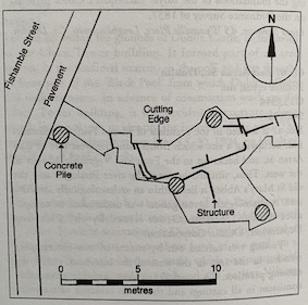
Inspection of the (1989) planning decision by the Office of Public Works and an assessment of a revised sub-structure design led to a decision by the OPW that no pre-development archaeological excavation would be necessary; all foundation structures except the piles were designed to lie above the archaeological levels recorded in the archaeological assessment. This design was based on the results of three boreholes.
A watching brief on the excavation for foundations was requested, however, with adequate provision being made for the recording of any features or structures of archaeolgical significance which may be exposed.
During the inital phase of the work archaeological deposits were exposed at the back of the site in one of the ground beam trenches. Subsequent excavation through archaeological material in other ground beam trenches and the lift pit location at the back of the site became inevitable. Also, all formation levels in the archaeologically sensitive areas were raised by 300mm and the drainage runs were sleeved through the ground beams rather than being placed beneath them. Accordingly all excavation which would otherwise have been carried out mechanically was done by hand, under licence, and fully recorded.
The trench in which archaeological deposits were first revealed, at the extreme north-east side of the site, was excavated for a ground beam in this location. It measured 9.3m north-south, was 1.7m wide and cut through a maximum of 1.3m of archaeological material on its eastern side. On the western side, however, pre-existing buildings had disturbed the profile.
Subsequent hand excavation was limited to the lift-shaft area and the bases of trenches excavated for adjacent ground beams. As a result, the excavated area has a very irregular shape. The main focus of excavation was an area measuring roughly 5m sq with a projection, at the north-eastern side, measuring 8m east-west by 1.6 north-south. The area had been piled prior to excavation and construction was under way during the excavation.
A depth of approximately 1.6m of archaeological deposits and features was excavated at the south-eastern corner of the area, with approx. 0.5m–0.6m removed elsewhere.
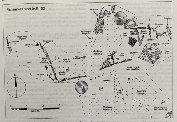
The excavation revealed the remains of portions of up to nine seperate structures, with associated layers. In the north-east corner, where the archaeological deposits were deepest, approximately six layers of habitation were identified in almost 1.6m of stratigraphy. This indicated a slight natural fall of 0.25m–0.3m in the archaeological layers from south to north.
The most complete plan indicated a post and wattle house (see above, Structure C) orientated east-west and measuring a maximum excavated length of 6.2m east-west by 4m north-south. The threshold of a second structure (Structure E) lay to the west suggesting there must have been some form of access between both structures to Fishamble St. The buildings were packed tightly together and were all built of post and wattle, with square and rectangular roof supports and sod or clay floors.
The finds included bronze pins, fragments of bone combs, 12th-century pottery, including French imports and some coarse cooking ware. Copious amounts of animal bone, including a number of small mammal bones, were retrieved from the four medieval pits, F7, F8, F23 and F34.
It is clear that a comprehensive preliminary survey of this site and the presentation of an accurate archaeological deposit model to the design team would have prevented what must be considered an unacceptable level of disturbance to the archaeological deposits.


