1994:029 - KILCOMAN CASTLE, Kilcolman Middle, Cork
County: Cork
Site name: KILCOMAN CASTLE, Kilcolman Middle
Sites and Monuments Record No.: N/A
Licence number: 94E0108
Author: Eric Klingelhofer, History Dept., Mercer University
Author/Organisation Address: Macon, Georgia, U.S.A. 31207
Site type: Castle - tower house
Period/Dating: Multi-period
ITM: E 558059m, N 611353m
Latitude, Longitude (decimal degrees): 52.252298, -8.614258
From July 17 to August 13, teams from The Earthwatch Foundation for Field Research, Boston, USA, carried out archaeological excavations at Kilcolman Castle, near Doneraile, Co. Cork. The site lies at the eastern end of a low ridge overlooking Kilcolman Bog and its small lake. Acquired by the poet Edmund Spenser in 1589, the castle was attacked and burned in the Tyrone Rebellion of 1598. The excavation is the first home of an Elizabethan colonial landowner (and one of the few tower-house castles) to be examined archaeologically. The 15th-century tower house or ‘keep’ has now only one vaulted storey supporting portions of upper walls and a 16th-century turret for a stair and ‘garderobe’ privy. The bailey or ‘bawn’ enclosure wall survives above ground in short sections east and south of the tower house.
The Kilcolman project is part of a long-term archaeological study of Elizabethan colonization. Following a 1993 season of architectural drawings, site survey, and vegetation clearance, the 1994 excavations took place with a grant from the College of Liberal Arts, Mercer, and with assistance from University College, Cork.
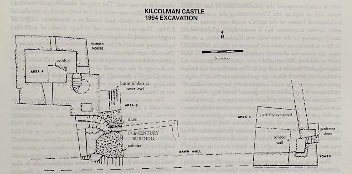
Three areas were chosen in 1994 to examine: the towerhouse, the bawn wall, and the likely location of the castle hall.
Area A (2m x 2m) comprised the south-east quadrant of the ground floor interior of the tower house. The Harold-Barry family’s efforts in the 1850s to preserve the castle had produced a mortar floor over a rough stone bedding, but both had suffered since from the depredations of cattle and treasure hunters. Beneath this 0.2m thick deposit was a fairly level surface comprising outcrops of the natural limstone supplemented by a well-laid cobbling, which is most readily ascribed to the occupancy of Spenser. The cobble flooring covered a mixture of clay and soil associated with the mortared stone foundation for the inserted stair turret. Several stakeholes found parallel to this foundation were probably caused by its construction scaffolding. Area A was excavated to natural and backfilled.
Area B (5m x 7m) examined the 4m-high platform behind the bawn wall at the south-east of the tower house. Beneath the topsoil, spreads of demolition rubble 0.4m thick had been cut by 1.2m deep trenching associated with Victorian repairs to the tower house. Unexpectedly, removal of more rubble layers exposed the remains of a cobble-floored structure built against the interior of the south bawn wall (later ‘robbed’ of its masonry). This building measured 3m north-south internally and may have extended 10m east, where earthworks suggest a robbed north-south wall. Its north wall was only 0.8m wide and lacked mortar, as did its west wall, which retained some clay bonding in spite of having been extensively robbed of stone. The cobble floor survived better, with evidence of burning against a 2m-wide fireplace in the west wall. Evidence suggests that the north and south walls angled inward shortly before reaching the west end, which may indicate the hipped roof commonly found in thatched buildings with timber-framed walls. The thinness of the walls here and the use of clay as bonding material instead of mortar supports the interpretation that they served as foundations for timber framing. Attached to the north wall, an open-sided shed was indicated by a 2m-wide cobbled area with a simple V-shaped drain running east-west, its west terminus unfortunately destroyed by Victorian trenching. Overlying rubble with pottery and tobacco pipes of the 18th century may provisionally date this building to the 17th-century, and it is tempting to associate it with the ‘convenient English house’ erected by 1622 to replace the burned ‘fair stone house’ of Spenser.
Test excavation north of this timber-framed building found that it had been erected upon demolition rubble over a destruction horizon of ash, burnt clay, and charred timbers in situ. The parallel orientation and close, regular spacing of these timbers suggest a wooden floor consumed in a general conflagration. In the center of Area B, the Victorian trench had cut through a destruction layer 0.3m thick, as well as a north-south stone wall foundation that was probably the original west bawn wall.
Area C (5m x 5m) examined the junction of the south and east bawn walls, a promising location for the castle hall. No floor level was reached, but the removal of rubble tips and robber trenches exposed the preserved interior face of the bawn wall as high as 2m. Understanding the complicated architectural history of the castle’s south-east corner must await further excavation, but it seems that a splayed (window?) opening in the east wall was blocked when a small (3.5m x 4.5m) corner tower was inserted or rebuilt. At its final stage, the tower was of several storeys, with external wall 1.6m thick at the base, but reduced by an internal ledge (stair or floor support?) to only 1.1m thick. The east face of the tower was pierced by a 0.8m-wide garderobe chute. Although garderobe towers may stand independently on bawn walls and embrasures are possible at the ground level (e.g. Askeaton Castle), the combination of the two here suggests that the surface indications of a hall at the south-east corner of the bawn cannot yet be dismissed. The south wall appears to have undergone a number of changes, but its details have been obscured by the robbing of its exterior facing stones. The excavation of Area C also revealed that the bawn was not a true rectangle; the south wall (1.6m thick) met at an angle of 81 degrees.
Few finds were noteworthy in themselves. Those needing conservation were removed to Mercer University for treatment and study. From the rubble of Area C came a late medieval buckle plate, and rubble layers around the tower house yielded much window glass and lead window fittings, which are most likely Elizabethan. A pewter spoon handle could also date to Spenser’s period. North Devon gravel-tempered pottery may indicate an occupation of the site in the 17th century, when the destroyed tower house was replaced by the timber-framed house of Area B.
The 1995 plans are to expand and fully excavate Areas B and C, obtaining the stratigraphy of Spenser’s occupancy and earlier, and to trace the bawn wall circuit by a series of short trenches at locations suggested by topographical and resistivity surveys carried out in 1993 and 1994.