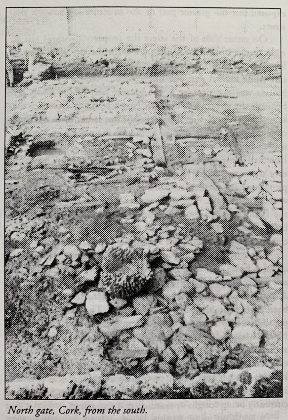
1994:025 - CORK: North Gate, Cork
County: Cork
Site name: CORK: North Gate
Sites and Monuments Record No.: N/A
Licence number: 94E0080
Author: Maurice F. Hurley, Cork Corporation
Author/Organisation Address: City Hall, Cork
Site type: Historic town and Town defences
Period/Dating: Late Medieval (AD 1100-AD 1599)
ITM: E 566957m, N 572062m
Latitude, Longitude (decimal degrees): 51.899730, -8.480143
The site was located at the north end of North Main St. and was bisected by the street. Prior to excavation it had been occupied by a garage/filling station and a surface car park. Cork Corporation’s Historic Centre Action Plan recommended the re-establishment of the North Gate as a symbolic gateway to the city. In addition to the proposed widening of the Quay, the site will be the subject of an international architectural competition to provide a high profile flanking building.
The archaeological excavation was an integrated project jointly funded by Cork Corporation Roads and Housing Departments and by the EU Urban Pilot Project Scheme. Excavation of 1,485 sq. m commenced on June 6 and was completed on November 4. The main features uncovered were a 33m length of city wall, a plinth of the gatetower, four burgage plots on the western side of the street and two on the eastern side. The paved surfaces of three laneways were excavated. The location of the lanes varied from level to level. Other excavated features included a corn-drying kiln, two bakeovens and an industrial area–possibly a bloomery.
Only the lowest levels contained well-preserved organic material. The earliest pottery recovered from the site was of mid 13th-century date and the bulk of the pottery dated to the late 13th century–mid 14th century. The majority of the 6,000 or so sherds were Saintonge ware with a significantly high proportion of highly decorated polychrome and all over green wares. The assemblage corroborates evidence from the 1992 excavations at Kyrls Quay / North Main Street (Excavations 1992, 8–9) where the bulk of the material also post-dated the mid-13th century. It is apparent that a developed settlement on the North Island (North Main St. area) was significantly later than the occupation of the South Island where the occupation dates from the later 12th century or even earlier.
On the eastern side of North Main St. two substantial stone walls were revealed. The inner (southern) wall had a vertical well-built face and was 1.04 m in thickness. This wall may have been the earliest city wall in the area and may also have provided a quay. At a maximum distance of c. 5.3m to the north a second wall was c. 1.9m wide and stood to a height of 2.46m. It was clearly of defensive character and was similar in proportions to the city wall excavated elsewhere in Cork. The area between the walls was filled with highly organic urban refuse.
To the west of North Main St. a rectangular bastion was exposed but the greater part of the structure lay beneath the street.
On either side of the street the property divisions ran at right angles to the street and parallel to the city wall. Several levels of clay floors were excavated and there were two hearths, one stone kerbed and one unenclosed. Detailed evidence for houses was not present as the greater part of the floors lay beneath the street. The modern North Main St. occupies the same line as its medieval predecessor but it has been widened considerably. There was no evidence for wattle or wooden walled houses and the earliest houses in the area appear to have had stone walls or certainly stone foundations. The property units varied between 6–8m in width and the burgage plots probably stretched from the street to the eastern and western city walls. The street evidently occupied the crest of the island and the ground sloped away to either side. Stone-lined drains led from the backs of the houses, usually in the centres of burgage plots but sometimes beneath the laneways.
The corn-drying kiln was of the key-hole variety, with a circular bowl and long flue. The preliminary examination of soil samples provided little clue as to the function of the kiln. A complex of wooden beams and a stone structure (photo) has been tentatively identified as a bloomery. The basal frame of a possible wheel race was recorded on the eastern side of the North Main St. An in situ anvil was located c. 1.5m to the south of the wheel race. The anvil was set in a foundation bed of paving and clay. An undershot wheel may have powered a hammer. A pit-like structure (possible furnace) was located immediately north of the wheel race. Comparative material is currently being sought to examine this suggestion.
In addition to excavation in advance of redevelopment other aims of the project were to raise awareness of the archaeological heritage and genesis of the historic centre of Cork and to demonstrate the excavation process to local people, developers and tourists. The EU Urban Pilot Project funding was used for promotion and publicity including guided tours. Most of the city schools visited the site.
A study to examine the feasibility of enhancing future redevelopment of the site by the incorporation of ancient structures as an integral part of the new buildings and roadway is currently under way.