1994:001 - ANTRIM CASTLE GARDENS, Antrim, Antrim
County: Antrim
Site name: ANTRIM CASTLE GARDENS, Antrim
Sites and Monuments Record No.: SMR 50:109
Licence number: —
Author: Malachy G. Conway
Author/Organisation Address: 696 Ravenhill Road, Belfast BT6 OBZ
Site type: Designed landscape - formal garden
Period/Dating: Post Medieval (AD 1600-AD 1750)
ITM: E 714568m, N 886868m
Latitude, Longitude (decimal degrees): 54.716830, -6.221790
Since 1991 Antrim Borough Council have embarked on a project to ‘reconstruct’ the 17th-to early 18th-century formal garden layout within Antrim Castle Gardens, funded by an EC grant. Previous excavation by T. Reeves-Smyth concentrated on the site of the supposed parterre known as Massereene Park as well as a small cutting in the ‘Old Grave-Yard’ which extends into the area known as ‘The Wilderness’ (Excavations 1991, 1). The Massereene Park parterre was reconstructed during 1992/93 allowing the next stage of reconstruction within ‘The Wilderness’ area, planned for 1994/95, to commence.
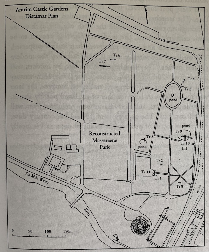
Excavation was undertaken during February 1994, financed through Taggarts Landscape Architects, Belfast, on behalf of Antrim Borough Council and under licence from Environment Service DoE (NI). The objective was to record the construction, sequence and layout of paths and the validity of other garden features within the woodland bosquet, which were recorded on the 1st and 2nd Edition OS maps of Antrim. The 1st Edition map of 1832 displayed the elaborate layout of the parterre within the Massereene Park while ‘The Wilderness’ consisted of a large main oval pond, a smaller circular pond and a simple series of paths. The 2nd Edition OS map of 1857 showed that the Massereene Park had reverted back to an open grassed area while, in contrast, ‘The Wilderness’ had become the focus with the addition of two further small ponds and a more elaborate interconnecting series of paths. Due to the heavily wooded nature of ‘The Wilderness’ and the unsuitability of geophysical techniques to record the position and extent of garden features, archaeological excavation had to be selectively used to locate pathways and other features. The figure provided shows the position of excavation cuttings in relation to surviving garden features.
The two components of garden layout within ‘The Wilderness’, paths and ponds, were examined. Excavation of paths concentrated on trying to establish the validity of those paths from the 1857 2nd Edition OS map which were no longer visible (Trenches 1–3), while an unrecorded stone-paved path located directly to the north-east of the main oval pond, found during the initial survey, was excavated to establish its orientation, dimensions and construction (Trenches 4–5). The two smaller infilled ponds to the south-west and south-east of the main pond were examined to establish their construction method (Trenches 8–9). Further trenches were opened in the area of the possible third small pond associated with several paths and located west of the main pond on the 2nd Edition map, to verify its existence (Trenches 6–7). A large treeless area to the south of the small infilled south-eastern pond was mechanically stripped in an effort to maximise the chances of locating garden features. Finally a small trench was opened within the eastern edge of the ‘Old Grave Yard’ beside a small, flat D-shaped stone (resembling a threshold or step stone), which, when lifted, was found to directly overlie path-like material (Trench 11).
During the 1940s, Antrim Castle Gardens played host to the U.S. Army and while the barrack buildings were demolished 30 years ago, several foundations can still be traced within ‘The Wilderness’ area. Finds from some of the excavation cuttings were numerous and almost exclusively comprised of broken NAAFI cups and plates, most stamped ‘1942’. As the excavation progressed it became apparent that this phase of activity at the site had a detrimental impact on the survival of some of the paths shown on the 1857 map. It would appear that the present paths that can be transcribed to the map layouts have survived because they represent the main thoroughfares and that subsidiary paths have disappeared through disturbance and perhaps deliberate removal.
Evidence for original paths was only found in Trenches 1, 4, 5 and 11. In Trench 1 the remains of one path was uncovered out of three paths shown on the 2nd Edition map; two had been removed by activity during the 1940s. The surviving path, oriented east-west, had consisted of an orange coloured flint pebble path between 2.6m and 2.8m wide, with the small flint pebbles 10-20mm in size lying on a founding deposit of coarse gravel. No evidence for path edging was found. At a latter stage the path had been resurfaced using a fine green sandy gravel, again without edging. Trench 11, inside the recess ‘Old Grave Yard’, confirmed that it had once been a gravelled area utilising small orange coloured flint pebbles 10-20mm in size, corresponding with the original path found east of the recess in Trench 1. A previously unrecorded paved path was excavated in Trenches 4-5, lying directly to the north-east of the main oval pond, measuring 1.5m wide and an estimated 15m long, cut into the natural orange clay subsoil. The path consisted of a neat linear arrangement of large angular basalt stones and flat slabs set into dark brown soil intermixed with small angular basalt stones, which had a dual function of giving the path a stable foundation as well as fill for the interstices of the large paving stones, giving the path an even and level effect. No date for the path was obtained, but it is assumed that it is late 19th to early 20th century in date.
Of the four ponds illustrated on the 2nd Edition map, only the large main oval pond is presently used as a garden feature complete with a pseudo-crannóg in its centre and, of the three smaller ponds, only the two located to the south-west and south-east of the main pond are visible as circular or oval depressions (one surrounded with a tree-ring). Mechanical excavation of Trenches 6-7 in the area of the possible third small pond shown to the west of the main pond on the 2nd Edition map failed to find any evidence to support its existence or that of any pathway shown in association on the map. Trenches were mechanically cut across the two small visible infilled ponds to examine their construction. Trench 8 cut across the pond to the south-west of the main pond, confirming it to be a small shallow ornamental pond about 16m in diameter and 0.55m deep. The pond was of simple construction being a shallow cut into the orange clay subsoil and with no sign of revetment, perhaps because of its shallow nature. The primary fill consisted of a sticky grey-black glar 0.2m deep, overlaid by a very humic black soil 0.2-0.4m deep which had been partly covered by the slumping of topsoil at the edge of the pond. Trench 9 placed across the pond to the south-east of the main pond also demonstrated a simple clay-cut construction without revetment. The pond was found to be 15-16m in diameter and 0.64m deep, much smaller than the enclosing tree-ring which is 20x24m in size. The primary fill consisted of a compact layer of tree branches and roots up to 0.35m deep which was overlaid by a humic dark-brown to black silty soil 0.7–0.8m deep, used to infill the pond completely. No evidence of sluice drains were encountered during excavation of the two small ponds, probably because they were small and shallow enough to allow any build-up of silts to be cleared out by hand. The excavation would also suggest that both ponds were relatively short lived and neither appear to have been re-cut at any stage.
The excavation demonstrated that the use of the Castle Gardens by the military during the 1940s had been detrimental to the survival of some of the paths within ‘The Wilderness’, however a correlation was achieved between certain surviving features and the 19th-century maps. The excavations in both 1991 and 1994 were undertaken specifically to achieve this correlation between archive accounts and physical remains in an attempt to give greater accuracy in the reconstruction of the Castle Gardens.