1993:202 - SLIGO: Rockwood Parade Development, Sligo
County: Sligo
Site name: SLIGO: Rockwood Parade Development
Sites and Monuments Record No.: N/A
Licence number: 93E0118, 93E0162
Author: Eoin Halpin, ADS Ltd.
Author/Organisation Address: Powerhouse, Pigeon House Harbour, Dublin 4
Site type: Town
Period/Dating: Post Medieval (AD 1600-AD 1750)
ITM: E 568958m, N 836005m
Latitude, Longitude (decimal degrees): 54.271910, -8.476572
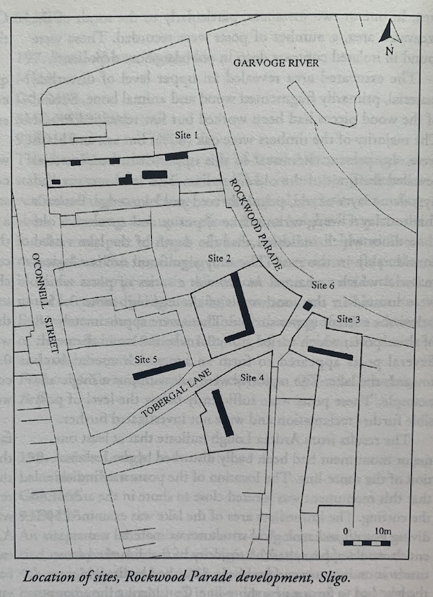
Site 1: 30 O’Connell St.
The site of 30 O’Connell St. contains evidence for a plot lay-out, probably post-dating 1600. This lay-out consists of two parallel walls, whose inside faces are some 5m apart, which run from the street front eastwards, some 50m, towards the river. In at least three places along its length, cross walls were noted. All of the walls examined were founded on bedrock and measured 0.6m thick. In one case, at the inside face of the western-most cross wall, a plinth was noted, some 0.2m above bedrock, which may represent an original floor level. A maximum of 0.35m depth of occupation soils was recorded at this western end. Elsewhere the archaeology consisted of up to 1.5m of redeposited soils, dumped in an area prior to the construction of the plot, as land fill and reclamation, behind the initial walling of the river Garvoge.
Site 2: 25B Tobergal Lane, Rockwood Parade
The trial trenching revealed bedrock to lie at a fairly consistent 2m below present ground level along the east-west transect but it was noted to rise gradually to the south away from the river. The north-west corner of the site was made up using a large deposit of stone and boulders and was subsequently cut through by a wooden culvert. The remainder of the site consists of up to 1.5m of redeposited soil dumped in the area as land fill and reclamation behind the initial walling of the river Garvoge. The remains of two late cross walls were cut by the line of the trench, as well as a pair of large, stone-filled, wooden boxes, used as early foundation pads for subsequent building, and finally the cobbled yard dating to the use of the site by a coal merchant.
Site 3: 8-9 Grattan St (yard to rear)
A 16m-long trench was machine excavated down to bedrock. The trench ran east-west parallel to the line of the river Garvoge. A 2.5m section was excavated midway along the length to allow for a live sewage pipe. Results revealed that the ground consisted of between 1.5m and 1m of redeposited soil dumped in the area as land fill and reclamation behind the initial walling of the river. A single cross wall was noted, founded on bedrock, but post-dating the land fill, which was seen to be a continuation of an early plot line. Two other walls, much later in date, were noted in the southern section but neither continued across the line of the trench. These may form the corner to a relatively modern building.
Site 4: Martin’s Site, Tobergal Lane
An 11m-trench was machine excavated down to bedrock. Results revealed that the ground consisted of 1.5m of redeposited soil dumped in the area as land fill and reclamation, behind the initial walling of the river Garvoge. A single stone-filled drain was noted running north to the river.
Site 5: Moffitt’s, Tobergal Lane
An 11m-long trench was machine excavated down to bedrock. The trench ran east-west, parallel to the line of Tobergal Lane to the south. Results revealed that the ground consisted of between 0.5m and 1m of redeposited soil dumped in the area as land fill and reclamation, behind the initial walling of the river. Two cross walls were noted, but neither were founded on bedrock, as well as a stone-filled drain. All of these features post-date the land-fill which is dated to the 17th century at the earliest, based on the discovery of a dump of leather material in one of the lower deposits.
Site 6: Test pit at north end of Tobergal Lane
The monitoring of the pad hole at the northern end of Tobergal Lane suggested that the lane did not pre-date the extant buildings on either side and therefore most likely dates to the period some time in the 17th century when the Garvoge river was walled in and the area of the rear of O’Connell St. was consolidated and developed. However, there is still the very real possibility that the actual line of the lane is much older, possibly medieval in date, and that evidence for this would have to be sought much closer to the junction between O’Connell St. and Tobergal Lane.