1993:070 - DUBLIN: Isolde's Tower, Exchange Street Lower, Dublin
County: Dublin
Site name: DUBLIN: Isolde's Tower, Exchange Street Lower
Sites and Monuments Record No.: N/A
Licence number: 93E0099
Author: Linzi Simpson
Author/Organisation Address: 45 Wyattville Park, Loughlinstown, Co. Dublin
Site type: Town defences
Period/Dating: Multi-period
ITM: E 715264m, N 734158m
Latitude, Longitude (decimal degrees): 53.345078, -6.268940
The site is bounded by Lower Exchange St. on the south and Essex Quay on the north and lies along the known circuit of the medieval walls of Dublin. The excavation revealed a circular mural tower (below), identified as ‘Isolde’s Tower’, which had been demolished to almost foundation level in the 17th century. The city wall was also located abutting the tower on the western and southern side and following the line of Lower Exchange St.
The tower occupies the north-east angle of the city wall and projected into the river Liffey with the Poddle along the eastern side. It formed part of the re-vamp of the city defences, dated to c.1260, which resulted in an extension of the city walls to encompass reclaimed land stretching to the banks of the Liffey.
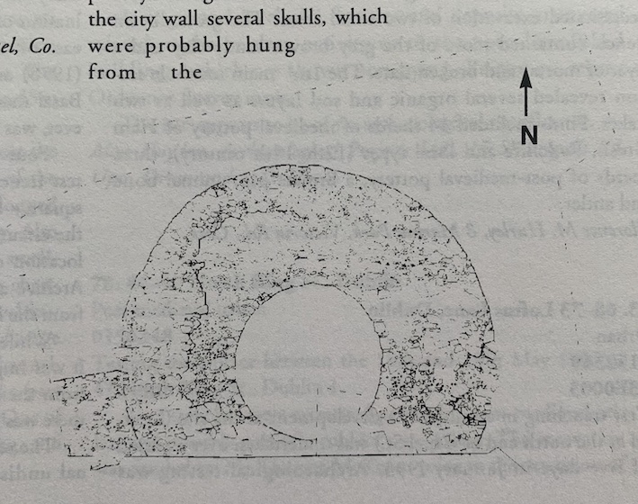
The tower
The tower, which is circular in plan, has an internal diameter of 4.5m and walls which were almost 4m thick. At its highest, at the western side, it survived to almost 2.5m while being less than half that height on the eastern side. It was built of regularly coursed limestone blocks and faced internally and externally with a strongly mortared rubble core. The start of a batter was visible on the western side.
The tower sat directly on river gravels on a rough plinth and the interior had been back-filled almost immediately with deep deposits of silt, possibly to stabilize the base.
The city wall
The city wall was exposed on the western side, abutting the tower and measuring 1.8m wide by 1.1m in height. The facing stones had been robbed out with little more than the mortared rubble core still in situ. A drain/latrine extended through the wall on the western side. At the southern side of the tower only the eastern face of the wall was exposed.
The seventeenth century
On the western side of the tower the city wall was replaced by a second wall which ran parallel and was constructed of regular ashlar blocks. This may have formed part of the re-fortification of the tower in the form of a ‘block house’ or alternatively it may represent a new quay wall. The 13th-century masonry of the tower was removed to facilitate the bonding in of the new wall.
The finds
The 17th-century reconstruction programme cut into the gravels and silts which had built up against the wall of the tower. Thus there were no medieval deposits in situ at the western side of the tower. On the eastern side, however, the gravels and silts produced imported and locally made pottery of Anglo-Norman date. At the base of the city wall several skulls, which were probably hung from the wall, were found imbedded in the river silt. An extensive range of post-medieval pottery, dating from the 17th century onwards, was also recovered.