1993:059 - DUBLIN: Christchurch Place, Dublin
County: Dublin
Site name: DUBLIN: Christchurch Place
Sites and Monuments Record No.: N/A
Licence number: —
Author: Claire Walsh and Alan Hayden
Author/Organisation Address: 15 St. Brigid's Road Upper, Drumcondra, Dublin 9
Site type: Historic town
Period/Dating: Multi-period
ITM: E 715121m, N 733825m
Latitude, Longitude (decimal degrees): 53.342119, -6.271207
The excavation of this site measuring 16m by 25m took place over a 15-week period from lst February to 15th May 1993. The work was funded in total by Pierse Contracting Ltd. who were at that time joint developers of the site.
The depth of archaeological deposits varied from 3m at the north end of the site to 5.5m at the south end. Safety measures reduced the excavation area to 11m x 17m at the lowest level of the site.
The site is located off Ross Road, and is bounded to the north by a development site to the rear of St. Nicholas’s church. Previous excavation work in the immediate area was carried out from 1972 to 1976 by the N.M.I. in an area to the north-east of the present excavation and linked to it by a 2m x 2m area. The earlier excavation uncovered the remains of plots and structures dating from the mid-10th to the early 14th centuries.The present excavation uncovered the remains of the earliest earthen defences at the south side of the town. Over time, these rose from a simple, low counterscarp bank, less than 0.75m in height, to a raised earthen mound almost 4m in height, and c. 5m in width. This was in part laced with post and wattle fences, and at one point, crowned with a post and wattle fence, set in a trench. In contrast to the banks of similar form and date excavated at Wood Quay, Dublin, timber survived poorly in the clays and marls at Christchurch Place. This form of defence was replaced in the 12th century by a stone wall.
The 12th-century wall survived to a maximum height of 3.5m and extended across the full width of the excavated area. The construction trench at the rear of the wall was cut through the southern tail of the earlier earthen banks. Projecting footings occurred on both sides of the wall, however, the plinth on the inside (north) side was sealed by the sterile boulder clay-derived fill of the construction trench. The south (front) face was generally vertical but in places the upper levels oversailed the lower slightly. The rear face was battered. This wall was partially demolished and in some places completely robbed out, in the later 12th century.
At the south end of the site the Anglo-Norman town wall was uncovered. Only its northern (interior) side could be examined. A break occurred in the wall where it possibly turned outwards to form a hollow-backed D-shaped tower-“Geneval’s Tower”. The hollow back was later closed up by another narrower stone wall. About 2m of organic refuse, of late 12th to mid-13th century date, formed between the demolition of the pre-Norman wall and the construction of the stone building described below.
A large sub-rectangular stone building (A) measuring 6.4m east-west by 11.6m north-south was built abutting the north side of the Anglo-Norman town wall in the area of the blocked break in the wall. The remainder of the building which lay to the south of the excavation was recovered in further work on the site undertaken by Margaret Gowen in the summer of 1993 (See below, No. 60). The east and west walls of the buildings were set into deep construction trenches which reached to boulder clay, while the north wall of the structure was footed onto the earlier, defunct town wall. The north and south walls of the buildings are not parallel, the northern wall being off-line as it was built using the 12th- century town wall as its footing.
Two stone piers built in deep trenches in a line roughly down the centre of the structure held the decayed remains of posts which would have supported the floor of the second storey of the building. A primary doorway, with Dundrystone jambs, was located in the east wall of the building. This was 1.7m above an external pathway which led to the doorway, and some form of removable ladder or steps would have been used to gain access to the doorway. This is a feature typical of 13th-century castles.
The primary floor level lay 1.4m below the level of the sill of the east doorway. It was a layer of yellow clay and spreads of sand and mortar which overlay the tops of the piers. Successive reflooring levels and modifications of the interior of the main building continued in an unbroken sequence into the middle of the 16th century. In the late 14th–15th century, the building was used for some industrial activity, notably roof and floor tile manufacture.
This building was possibly a garrison for troops defending the town wall. It is attached to the inner side of Geneval’s Tower, one of the mural defensive towers. It is unclear whether it is part of the tower proper or the building referred to in the 14th century as Geneval’s Inns. This was the property of Sir Geoffrey de Geneville, who was Justiciar of Ireland from 1273 to 1276, during which time he thrice attempted to quell the rebellious tribes of Wicklow at Glenmalure.
A further stone building (B) was added on to the west side of the structure in the later 13th or 14th century. In comparison to A, this was footed on relieving arches, which rested on shallow stone piers. Floor levels did not survive.
The east doorway of A was blocked up at this date, and a splayed doorway, leading into B, was opened in its west wall. By the time of Perrot’s (1595) survey of the town walls of Dublin, the upper floors of the larger structure are likely to have fallen into complete disrepair. While archaeological evidence for the longevity of building B is not available, it is possible that part of this complex is what is referred to as the “square within” element of “Geneval’s Tower”.
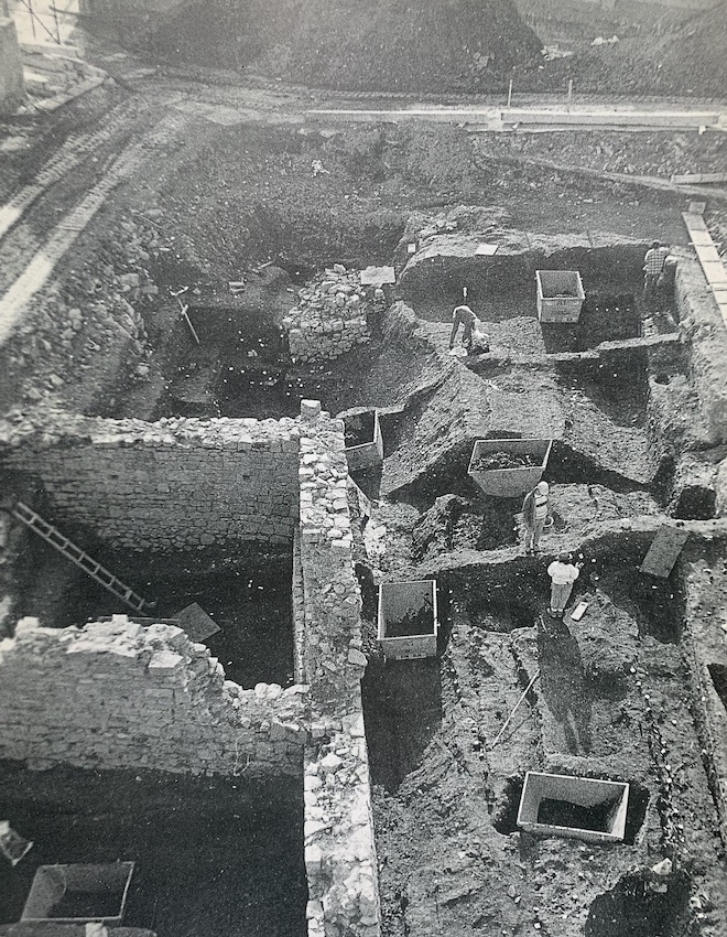
A photograph of excavations at Christchurch Place featured on the cover of the 1993 edition of Excavations (photo courtesy of Claire Walsh and Alan Hayden)