1992:110 - KILKENNY: Kilkenny Castle, Kilkenny
County: Kilkenny
Site name: KILKENNY: Kilkenny Castle
Sites and Monuments Record No.: SMR 19:26
Licence number: —
Author: Ben Murtagh, c/o OPW, Kilkenny Castle, Kilkenny
Author/Organisation Address: —
Site type: Castle - Anglo-Norman masonry castle
Period/Dating: Multi-period
ITM: E 650739m, N 655743m
Latitude, Longitude (decimal degrees): 52.650513, -7.250140
A second season of excavation was conducted in and around the Castle from June 1992 to January 1993. This was to facilitate on-going restoration work to the building, and was financed by the Office of Public Works. Seven different areas were investigated–three of which involved the completion of excavations that were begun during the first season of work in 1991 (See Excavations 1991).
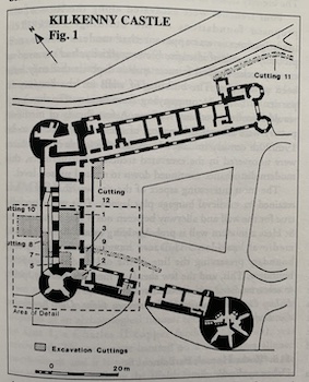
Cutting 1
This involved the completion of the total excavation of archaeological deposits beneath the large room known as G25 in the central wing of the Castle, in advance of the construction of a new cellar. The excavation revealed that the pre-castle ground level in the 12th century was as much as 3.6m below the modern ground floor. This was represented by a sod horizon.
Associated with the 12th-century ground level were the remains of a sod-built structure, roughly square in plan, with rounded corners. It consisted of 3 surviving low walls–the west wall having been destroyed by the construction of the base batter of the north-west curtain wall of the 13th-century stone castle. The sod building measured internally around 4.2m north-south by at least 4.6m east-west. It had a compact sod floor with a central hearth, and the remains of a small ‘furnace’ to the west. A series of post-holes were found, both within the interior and associated with the sod wall. Evidence for iron and bronze working, together with sherds of local cooking ware, were found in and around the building.
This building appears to have had a short life and was destroyed by the construction of a large earthwork on the site. This involved the digging of a deep fosse through natural deposits, and the construction of a high rampart within, overlying the sod building.
Evidence to date suggests that the trapezoidal plan of the present castle follows the outline of the above earthwork fortress, which may have been the one burnt by the King of Thomond in 1173. The remains of the rampart in G25 survived to a height of up to 3m. During the first half of the 13th century the north-west curtain wall together with a base barter was built on the outer slope of the rampart.
Cutting 3
Located at the south-west end of corridor 03, to the east of the West Tower, within the medieval courtyard of the Castle, the excavation of this cutting was completed in 1992. The remains of a stone-built structure, possibly a passageway were excavated. The fill contained local medieval glazed pottery. This in turn overlay a timber-built structure. Both features truncated the inner slope of the rampart of the late 12th-century earthwork castle.
Cuttings 5, 7, 8:
These cuttings were located to the north-east of the West Tower. Here the excavation of the steps of the sallyport, through the north-west curtain wall, was continued. This feature was first encountered during the first season of work (See Excavations 1991). To the north-east of the latter, below the corridor known as 03, the base batter of the north-west curtain wall was exposed.
Cutting 9
This was a cable trench, excavated across the west corner of the present courtyard of the Castle. It was 21m in length and averaged 0.75m in depth. The trench cut across deposits of the inner slope of the rampart of the earthwork castle.
Cutting 10
This was located in the Rose Garden, on the north-west side of the central wing of the Castle, over the site of the moat. It measured 7m x 6m, and was excavated to a depth of 7m. It revealed that the bottom of the base batter of the north-west curtain wall was 7m below the present ground level of the Rose Garden in this area. The base batter was approximately 5.5m in width and 8m in height. The finds recovered indicate that the moat was filled in, almost to present ground level, during the course of the late 17th century.
Cutting 11
This was a cable trench that was excavated across the park to the east of the Castle. It ran north from the present Thomastown Rd., to the boiler house on the north side of the river wing of the Castle. It was 130m in length and averaged 0.75m in depth. The finds recovered indicated that there was a build up of ground to the east of the Castle in the late 17th or early 18th century. The south end of the trench cut across the remains of the original roadway that ran from the city towards Thomastown up to the late 18th century.
Cutting 12
Located in the north corner of the courtyard of the Castle, it measured 5.4m x 3m, and was excavated to a depth of 2.75m. Archaeological deposits were encountered 0.32m below the present ground level. A large number of medieval deposits were exposed–represented by a series of ground surfaces that had gradually accumulated inside of the courtyard of the Castle throughout the middle ages. A large number of medieval finds were recovered.
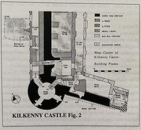
Although the present castle was largely rebuilt in the 19th century, the results of the first season of work (Excavations 1991) suggest that much of the early Castle remains buried beneath the modern ground level. The most recent season of excavation has not only confirmed this view, but has also thrown a great deal of light on the early development of the site, which was hitherto unknown. Further excavations in the Castle are planned during 1993.