1992:093 - DÚN AONGHASA, Kilmurvey, Inismor, Galway
County: Galway
Site name: DÚN AONGHASA, Kilmurvey, Inismor
Sites and Monuments Record No.: N/A
Licence number: —
Author: Claire Cotter, The Discovery Programme
Author/Organisation Address: 13-15 Hatch St. Dublin 2
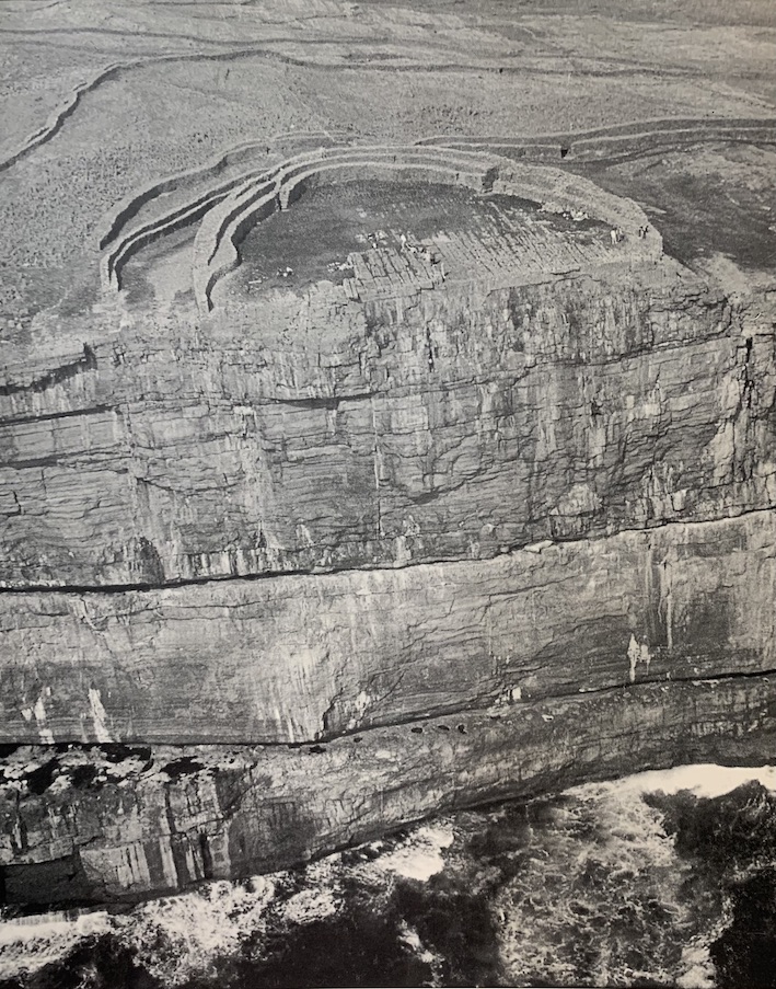
Site type: Cliff-edge fort
Period/Dating: Bronze Age (2200 BC-801 BC)
ITM: E 481676m, N 709732m
Latitude, Longitude (decimal degrees): 53.124994, -9.767921
As part of the Western Stone Forts project of the Discovery Programme, an 8-week season of excavation was carried out at Dun Aonghasa, Inismor, in summer 1992. The main objectives of the initial season were firstly to investigate whether any archaeological deposits were preserved in situ at the site and secondly to establish whether such deposits might provide secure dating contexts for the relative and absolute dating of the extant structural elements. To this end it was decided to commence a series of exploratory cuttings across a main axis of the monument.
The site is defended by 3 principal walls and a substantial chevaux de frise which lies outside the middle wall. Along the north/north-west sector an additional wall (possibly now incomplete) runs along the inner edge of the chevaux de frise. The fort is located at the cliff-edge at the southern end of a ridge. The relatively level summit of the ridge in the northwest quadrant appeared to offer the maximum potential for the preservation of archaeological deposits at the site. Excavation in this sector would also allow the structural sequence of the additional wall to be examined.
Two cuttings were opened and altogether an area of 445 sq. m was examined; Cutting I lay in the western half of the inner enclosure and Cutting II lay within the middle enclosure. Excavation has not been completed in either cutting.
Cutting I measured 39.5m by 12m. Prior to excavation areas of bedrock were exposed within the cutting. A slight rise in ground level adjacent to the inner enclosing wall was considered likely to be the result of accumulating wall tumble. Except for a small area in the north sector, the foundations of the enclosing wall were not visible prior to excavation.
The earliest structure uncovered to date is the remains of a roughly circular hut, 4.8m in diameter, and located in the western sector of the interior (Hut 1). The surviving walls are formed of low orthostats ranging from 0.43m to 0.6m in length and up to 0.29m in height. On the south and north the walling continues under the inner enclosing wall. No trace of an intermediate old turf level was apparent and within the cutting the remains of the hut lay directly beneath wall tumble which had been disturbed in the 19th century. The interior of the hut was filled with a midden type deposit and finds included coarse pottery sherds, fragment of a clay mould for a spearhead and a bone spindle whorl. On the evidence of the clay mould fragment a date in the Late Bronze Age seems likely for this hut site. A 2nd possible hut lies a short distance to tine east, but has not as yet been excavated. The partially preserved foundations of a 3rd hut were uncovered towards the centre of the cutting. The remains consist of an arc of walling 3.5m in length by 0.8m in width with a possible entrance on the east. Traces of paving are preserved in the interior. Only a thin layer of archaeological deposits survived in this area and the few finds recovered were from unsealed or unstratified contexts.
An accumulation of midden type deposits and small stone debris extended across most of the cutting and ran in under the enclosing wall. This material yielded around 120 clay mould fragments and moulds for a sword, spearhead, bracelet or ring and pin are represented. All are of late Bronze Age type. The midden layer also yielded c. 400 sherds of pottery, all belonging to slightly inturned vessels with internal bevels and probably flat bases.
A stone-lined trough and stone hearth uncovered a short distance east of Hut I had been cut down into the midden layer. A sample of animal bone from the fill of the trough has been submitted for carbon-14 analysis. Overlying the midden layer over much of the cutting was a layer of dark-brown humus which yielded modern and residual finds. A broad band of wall rumble directly underlay the sod adjacent to the enclosing wall.
Cutting II measured 13m by 4m. Prior to excavation traces of stone foundations were visible. Removal of the sod layer revealed the remains of a drystone wall running at right angles to the inner enclosing wall on the south and the middle enclosing wall on the north. The extant section, 9m in length and 0.75m in max. width, peters out at the stepped bedrock which forms the foundation of the inner enclosing wall. A deposit of midden material abutting the east face of the wall foundations continues under the inner enclosing wall and it seems likely that the newly exposed wall also predates the inner enclosing wall.
Approximately halfway along the cutting two opposed arcs of upright stones, 3m apart, may define a hut site. The interior contained a concentration of shells (barnacle and periwinkle) and animal and bird bones. No datable artefacts were recovered. The aceramic nature of the midden material raises the possibility that this phase of occupation does not belong to the Late Bronze Age period.
It is planned to undertake a second season of excavation at Dun Aonghasa in summer 1993.
An image of Dún Aonghasa featured on the cover of Excavations 1992 (Photo by Con Brogan).