1992:088 - GALWAY: Merchants Rd/Abbeygate St Lower, Galway
County: Galway
Site name: GALWAY: Merchants Rd/Abbeygate St Lower
Sites and Monuments Record No.: N/A
Licence number: —
Author: Dominic Delany, Archaeological Services Unit, UCG
Author/Organisation Address: —
Site type: Historic town
Period/Dating: Multi-period
ITM: E 529865m, N 724829m
Latitude, Longitude (decimal degrees): 53.269159, -9.051392
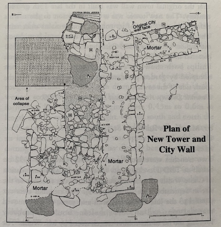
The excavation at Merchants Rd./Abbeygate St Lower, took place between 13th and 31st July 1992. The site, measuring 15m north-south and 19m east-west, was excavated in advance of a commercial development. Preliminary archaeological work at the site (1st-10th July) had uncovered the remains of part of the medieval town wall and the foundations of a projecting wall tower.
The town wall, where surviving, preserved traces of two phases of construction, an outer limestone skin (w. 1.15mm) having been built against the outer rhyolite face of the original wall. Archaeological deposits, post-dating the construction of the outer skin, survived below a wall foundation which ran along the eastern edge of Trench 2. The deposits were composed of tidal and organic material and contained considerable quantities of animal bone, fish bone and shell. These levels also yielded several sherds of post-medieval pottery, mainly late 17th-century gravel-tempered wares.
The tower named on 17th-century maps as the ‘New Tower’, is rectangular in plan measuring approximately 6m north-south and 4m east-west. The excavated remains of the base of the tower comprise the east wall and broken sections of the south and west walls. The walls are 1.3m thick and have a solid rubble and mortar core. Externally they are faced with coursed limestone masonry, unworked except at the south-east angle of the rower. Internally the tower was filled with stone and redeposited soil and the walls were roughly faced with randomly-packed masonry. The south and west walls of the tower were in a very ruinous condition, mainly due to disturbance caused by later wall foundations. The east wall, however, preserves much of the original fabric of the structure. This wall has a substantial external plinth (width 0.3m) composed of limestone and rhyolite boulders and smaller packing stones. The plinth is set in redeposited soil which overlies the natural boulder clay. The east wall is built directly against the outer rhyolite face of the original town wall. This suggests that the tower is later than the town wall and that it pre-dates the construction of the outer limestone skin.
The surviving literary and documentary sources suggest that the original town wall was built in the late 13th or 14th century. The new tower was a later addition to the town’s defences but the date of its construction remains uncertain. The tower is shown on all the surviving cartographic evidence, the earliest being the 1583 Barnaby Gooche map. The 1651 pictorial map of Galway and the 1685-6 drawing by Thomas Philips both show the excavated area then to have been occupied by garden plots, representing reclamation on the south side of the town.