1992:048 - DUBLIN: Bride St./Golden Lane, Dublin
County: Dublin
Site name: DUBLIN: Bride St./Golden Lane
Sites and Monuments Record No.: N/A
Licence number: —
Author: Andy Halpin
Author/Organisation Address: 5 Yellowmeadows Avenue, Clondalkin, Dublin 22
Site type: Historic town
Period/Dating: Multi-period
ITM: E 715234m, N 733707m
Latitude, Longitude (decimal degrees): 53.341035, -6.269554
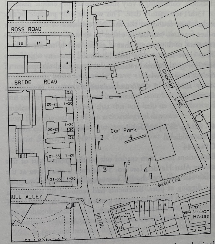
In April 1992 the writer conducted an archaeological assessment on behalf of Dublin Corporation on a site at Bride St/Golden Lane, Dublin. The site lies within the Zone of Archaeological Interest outlined in the Dublin City Development Plan, c. 100m outside the walled medieval town at the junction of 2 medieval streets. Bride St takes its name from St Bride’s (Brigid’s) Church, which was located c. 20m east of the present site. The church is of pre-Norman origin and Bride St itself is likely to be pre-Norman also. This is supported by a probable Viking burial in Bride St recorded in the 19th century. It is likely that suburban settlement spread along Bride St during the 13th century, if not earlier. Golden Lane is shown (as Crosse Lane) on Speed’s map of Dublin of 1610 and is almost certainly of medieval origin. Speed’s map depicts buildings on the northern corner of Bride St and Golden Lane and on the eastern side of Bride St, opposite St Bride’s Church.
Although, because of road widening, the present street frontages of the site are set back considerably from the medieval frontages, some archaeological material derived from medieval and post-medieval suburban settlement was to be expected. The programme of site assessment was designed to determine the pattern of archaeological stratigraphy along the Bride St (Trenches 1-3) and Golden Lane frontages (Trenches 5-6) with further trenches (nos. 1, 4 and 6), extended east and north in order to assess stratigraphy in the interior of the site.
Unfortunately, the assessment revealed that whatever archaeological material may once have been present along the two street frontages appears to have been removed by later building. In general undisturbed natural boulder clay, where it had not been disturbed by foundations for 18th/19th-century buildings, occurred at depths of between 1.5m and 1.7m below present ground surface, although at the extreme north end of the site a depth of 2.25m-2.75m was recorded. Immediately above boulder clay, in many parts of the site, was a layer of brown garden-type soil between 0.4m and 1.5m in thickness, containing a very small amount of ceramic material of 13th/14th-century date. This was the only possible in situ archaeology found on the site. No evidence of structures or other features was noted either in or under it, and it may represent nothing more than a garden soil of medieval date. Thus there seems to be little likelihood that any significant archaeological deposits relating to the medieval occupation of the site have survived.