1992:047 - DUBLIN: Bow Lane/Kennedy, Dublin
County: Dublin
Site name: DUBLIN: Bow Lane/Kennedy
Sites and Monuments Record No.: N/A
Licence number: —
Author: Andy Halpin
Author/Organisation Address: 5 Yellowmeadows Ave, Clondalkin, Dublin 22
Site type: No archaeology found
Period/Dating: N/A
ITM: E 713518m, N 733938m
Latitude, Longitude (decimal degrees): 53.343480, -6.295222
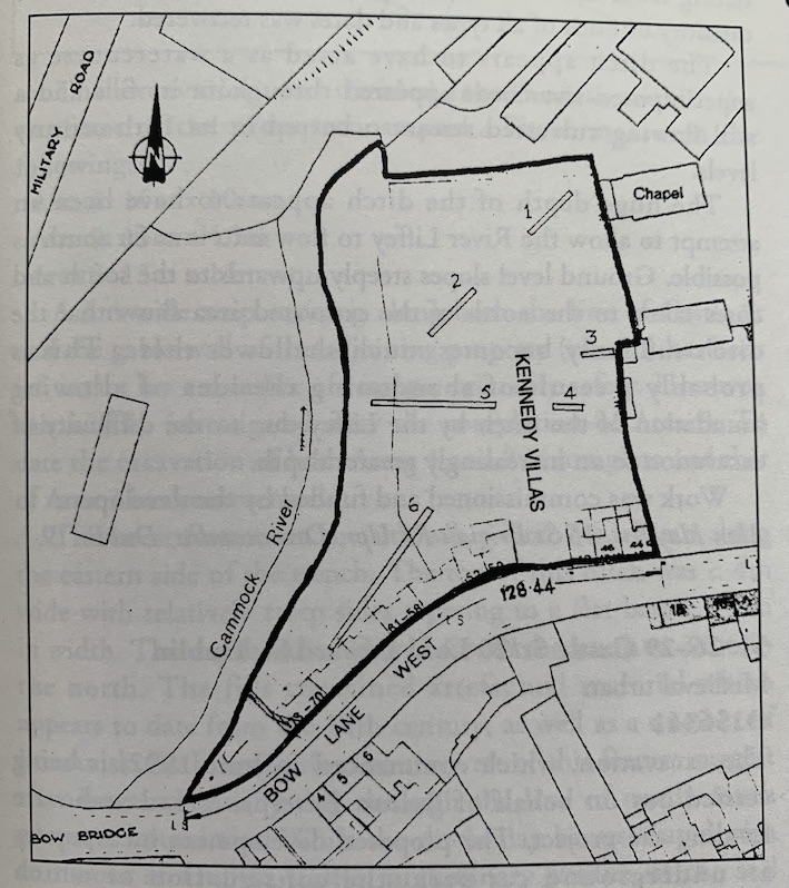
In April 1992 the writer conducted an archaeological assessment on behalf of Dublin Corporation on a site at Bow Lane West/Kennedy Villas, Kilmainham, Dublin. The site lies within the Zone of Archaeological Interest outlined in the Dublin City Development Plan for Kilmainham/Islandbridge. This Zone reflects past discoveries of Viking burials over an extended area of Kilmainham and Islandbridge. It is thought that the original Viking settlement of Dublin, the 9th-century longphort may have been located in this area. The present site is bounded on the west by the River Cammock, which flows into the Liffey at Heuston Station c. 300m to the north. The Royal Hospital, located c. 300m to the west on a sharp rise on the west bank of the Cammock, overlooks the site. Both the Royal Hospital and Heuston Station produced Viking burials in the last century.
The method of site assessment was the opening of 6 machine-dug trenches, each approximately 1m wide and between 10m and 38m in length. No evidence for Viking burials or indeed for any archaeological material whatever was noted in any of the assessment trenches. Extensive layers of fill and overburden proved to be entirely of recent (18th/19th-century) date.
It is noteworthy that all recorded findspots of Viking material in this area appear to lie to the west of the River Cammock. The results of this assessment may indicate that no such material is present on the east bank of the river. It may be that the 9th-century settlement was located in the angle between the Cammock and the Liffey, on the west bank, just as its 10th-century successor was located in a similar setting in the angle between the Poddle and the Liffey.

