1991:081 - KILKENNY CASTLE, Kilkenny
County: Kilkenny
Site name: KILKENNY CASTLE
Sites and Monuments Record No.: N/A
Licence number: —
Author: Ben Murtagh
Author/Organisation Address: 32 South Parade, Waterford
Site type: Castle - Anglo-Norman masonry castle
Period/Dating: Multi-period
ITM: E 650839m, N 655643m
Latitude, Longitude (decimal degrees): 52.649605, -7.248678
The excavation began in July 1991 and continued for a period of eight weeks. The purpose of the work was twofold: (a) to reveal more about the early history of the castle, and (b) to facilitate the ongoing restoration work to the same.
The excavation was commissioned and financed by the Office of Public Works.
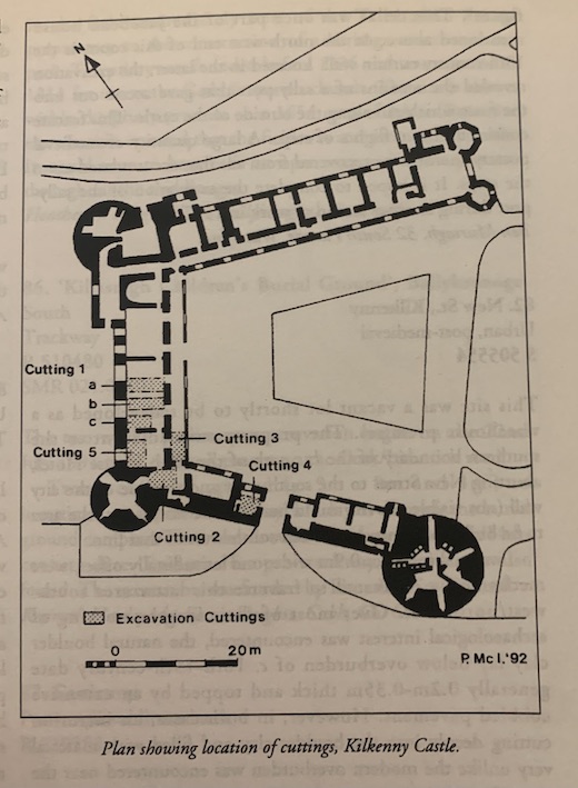
The work concentrated on the area of the castle that extended north-west from the Gate House in the Parade Wing, to the West Tower (see figure) and then north-east from the latter to about halfway along the Central Wing. The cuttings were located in five different parts of the above area of the castle, and revealed at least seven different levels of activity on the site – provisionally beginning in the 12th century.
CUTTINGS 1A, B & C
These consisted of three different cuttings that were located in a large room, known as G25, in the Central Wing. They revealed the remains of a large bank (Level 2) that ran south-west to north-east under the Central Wing of the castle. The bank consisted of layers of redeposited glacial clay and gravel – presumably excavated from the fosse outside of the castle. It survived to a maximum height of 2.85m and the top had been truncated by later building.
In G25, the pre-bank ground surface, which is 3.5m below the modern ground floor of the castle, underlies an extensive area of burning (Level 1). The latter produced evidence of bronze working, and it is hoped to return to excavate this level in greater detail in 1992. The bank may have enclosed the bailey of the first castle on the site that was burnt down by the King of Limerick in 1174. The excavation in G25 also revealed the foundation of the north-west curtain wall (phase 3) of the stone castle that was built by William Marshal the Elder, in the early 13th century. The foundation truncated the outer slope of the bank. This suggests either that the old fosse continued to be used or that it was redug.
CUTTING 2
This was located to the south-west of G25, in the room (G28) at the bottom of the stairway on the east side of the 13th-century West Tower – at the junction of the Parade and the Central Wings of the castle. Almost the total area of the room was excavated to reveal the foundations of the tower, and the curtain wall that runs southeast to the South Tower. Both truncated the earlier bank material that in turn overlay sod which was located 3.2m below the modern ground floor level.
Cutting 2 also revealed the remains of the south-west gable wall of the Jacobean house that once formed the north-west wing of the castle. It was in this building that the Papal Legate, Cardinal Rinuncinni, met the Supreme Council of the Confederation of Kilkenny in 1645. It was mostly demolished in 1824 during the reconstruction of the castle. The foundation of the gable wall truncated the bank of the prestone castle.
CUTTING 3
Located at the south-west end of corridor (G30) that runs along the south east side of the Central Wing. Here the remains of a passageway that ran towards the cellar of the Jacobean house was revealed.
CUTTING 4
Located in room G32 on the north-west side of the passageway of the Gate House that gives access from the Parade in the Courtyard of the castle (see figure above). Here the excavation revealed that the front wall of the Gate House, which was constructed around 1700, truncated the curtain wall, and overlay the foundation of the latter. As in the case of Cuttings 1 and 2, the foundation of the curtain wall truncated the bank that enclosed the bailey of the pre-stone castle. The bank overlay a layer of burnt wood chippings that in turn overlay sod – approximately 2.7m below the floor of G32.
CUTTING 5
Located in the north-west half of the cellar at the south-west end of the central wing of the castle. This cellar was once part of the Jacobean house mentioned above. At the north-west end of this room is the 13th-century curtain wall. Located in the latter, the excavation revealed the remains of a sally-port that gave access out into the fosse which ran along the outside of the castle. This feature consisted of two flights of steps. A large quantity of medieval pottery sherds were recovered from silt that accumulated upon the steps. It is hoped to complete the excavation of the sally-port during another season of work in 1992.