1991:078 - DYSART, Kilkenny
County: Kilkenny
Site name: DYSART
Sites and Monuments Record No.: N/A
Licence number: —
Author: Ben Murtagh
Author/Organisation Address: 32 South Parade, Waterford
Site type: Ecclesiastic enclosure
Period/Dating: Multi-period
ITM: E 659637m, N 639347m
Latitude, Longitude (decimal degrees): 52.502252, -7.121606
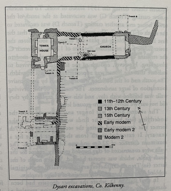
A second season of excavation was conducted at Dysart for a period of six weeks from September to November 1991. The work was funded by the Office of Public Works on the recommendation of the National Committee for Archaeology of the Royal Irish Academy. The first season of excavation was conducted in 1989 (see Excavations 1989, 33-4).
The remains of three stone buildings survive above the ground. The first building consists of the remains of a small oblong church that dates to the 12th century or earlier. The second building is a 15th-century tower house that stands to the west of the church. The third building consists of the remains of a long dwelling house of post-reformation date that extends southwards from the tower house. Three main questions were addressed during the 1991 season of work:
(a) the date of the church,
(b) the relationship of the latter to the tower house and
(c) the nature of the dwelling house
The date of the church
The removal of ivy and other vegetation enabled a closer examination of the surviving masonry of the church, which is oblong in plan, measuring externally 12.85m x 6.9m. It was revealed that the eastern third of the building is a 13th-century extension to the 12th-century church. A reused Early Christian cross slab that was recovered from the collapsed masonry of the north wall of the early church would suggest that the latter was not the first church on the Dysart site. There is also another early cross slab built into the west wall of the tower house.
The surviving walls of the early church, which are constructed mainly of large blocks of sandstone masonry, overlay plinths. The west wall did not survive above the ground, but a small cutting, Trench I, excavated at the northwest corner of the present building revealed the foundation. Internally the original church measured 8.02m x 5.35m.
The relationship of the church to the tower house
Above the modern ground level, there is a gap of just over 6m between the two buildings. During the later medieval period, some of the minor churches in Leinster had tower houses built at their west ends. However, the results from the 1991 season of work suggest that this was not the case at Dysart. This was revealed by the excavation of two cuttings, Trench F between the tower house and the church, and Trench E to the south. They indicated that during the course of the 17th-century, after it had gone out of use, the west wall of the church was pulled down, and the north and south walls of the building were joined to the tower house by two roughly built walls. The excavation in Trench F further revealed that this extension was floored with a rough cobbled surface, and may have functioned, with the church, as an outhouse or byte of the farmstead that was located at Dysart subsequent to the Reformation.
The nature of the dwelling house to the south of the tower house
According to tradition, this was the childhood home of the famous philosopher, Bishop George Berkeley (1685-1753). During the first season of work, a cutting, Trench C, was excavated across the site of the house (see Excavations 1989, 33-4). It revealed that two buildings stood on the same site subsequent to the Reformation. The situation became clearer during the 1991 season of work. To the north, a new cutting (Trench G) was excavated at the south of the tower house and another cutting (Trench D) was excavated to the south of Trench C. The work to date has revealed that the first house was oblong in plan and extended south from the tower house for a maximum distance of 17.1 m. In Trench C, the remains of the west wall had been destroyed by modern ploughing. However, enough of the foundation survived to indicate that the house was approximately 9.75m in width. The south end of the building was represented by an extensive foundation of large sandstones. The masonry of the surviving walls was bonded with clay, and this would explain why they did not survive above modern ground level.
The second house was longer and narrower than the underlying first house. The finds would suggest that the former was constructed during the second half of the 17th century. It extended south from the tower house for a maximum distance of 22.6m and was 7.65m in width. The walls were constructed of clay bonded masonry, except for the south gable, which was mortar bonded. To the north of the latter (in Trench D) the excavation revealed the original cobbled floor together with the remains of a large fireplace.
In west Trench D, where the upper deposits had been damaged by modern ploughing, the excavation revealed a series of postholes, together with part of the foundation of what appears to have been a circular house. These features cut into the underlying natural deposits. Not enough of the structure was exposed to give an adequate indication of its dimensions. Inside this structure, an oval pit was found, the fill of which contained a large quantity of iron slag. The features exposed in west Trench D may date from somewhere in the Early Christian period, however, further excavation would be required in order to verify this.