1991:027 - MOGEELY CASTLE, Cork
County: Cork
Site name: MOGEELY CASTLE
Sites and Monuments Record No.: N/A
Licence number: —
Author: Erik Klingelhofer
Author/Organisation Address: Dept. of History, Mercer University, Macon, Georgia 31207, USA
Site type: Settlement cluster
Period/Dating: Multi-period
ITM: E 595951m, N 594057m
Latitude, Longitude (decimal degrees): 52.098408, -8.059096
In July and August 1991, Mercer University sponsored a programme of archaeological fieldwork at Mogeely Castle and Curraglass, near Conna, Co. Cork. These two settlements are important to proto-colonial studies, because they are depicted in unique detail on the earliest estate map in Ireland, now among the Lismore Papers in the National Library of Ireland. The map covers land that Sir Walter Raleigh leased to Henry Pine; it was made in 1598, shortly before both communities were destroyed in Elizabeth’s Irish wars.
The site (Area D)
Mogeely Castle is now a deserted settlement. It retains the ruins of the largely 15th-century castle on a low, limestone-quarried bluff overlooking the River Bride; a bridge of some antiquity spanning the river at that point; a manor house, in origin probably early 18th-century and separated from the castle by field and quarry-pocked pasture; and the walls of a ruined Gothic church in a small graveyard that is still in use. The English colonial settlement stretched from the church to the castle, with a wide green that probably represented the castle’s former bailey. The ground between the castle and the church is fairly level, but slopes to north, east and south. The site marks the eastern end of a slight ridge of limestone capped by glacial drift deposits of clays and gravels. Despite this, the soil is generally light, dry, and stony; the pastures of Mogeely Castle are considered some of the best in the locality.
The primary target of the 1991 excavations was the house plot at the south-west end of the former village. It was chosen for several reasons. It lay at the end of the village opposite to the castle and therefore ought to have been relatively immune to activity around the castle in the medieval period, as well as in the Elizabethan and Cromwellian wars when military actions took place at Mogeely. Similarly, because the house plot was separated by the village street from the church and graveyard, its archaeological potential ought to be greater than that of the house east of the road. Nineteenth-century maps and present day observation show that much of the Mogeely vicinity was extensively quarried, but the field containing the house site seemed to have been untouched. These suppositions were sustained when results of the 1990 geophysical survey (by Geoscan resistivity meter) and of subsequent test pits (excavation units A, B, C) suggested that structural features and even associated occupation layers may have survived ploughing.
The excavation
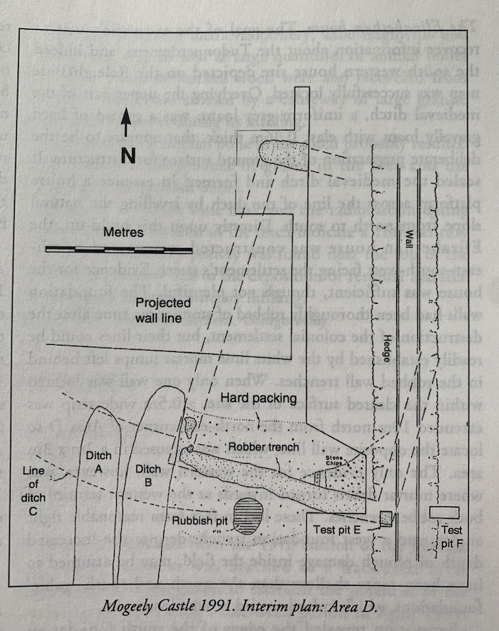
Two post-Renaissance ditches, previously located in a 1990 rest trench, cut through the centre of the site in a north-south direction. Ditch A (1.2m wide, 0.5m deep) contained artifacts of the early 19th century and cut the 18th-century Ditch B (1.6m wide and dug 1.6m below the topsoil). The slightly different orientations of the ditches most likely represent Georgian agricultural improvements and the establishment of the present field boundaries. The ditches may have served as field boundaries, but another function was revealed when portions of their lengths were completely excavated. The two ditches drained this area, which had been dug out and refilled with rubble, gravel, and clay, because underneath lay the much earlier Ditch C. This feature was 2.1m wide and 0.9m deep. Its curving north-west-south-east line contained a thick, moist, clayey silt. Although the excavation of the lower silt did not yield artifacts, Ditch C is undoubtedly medieval in origin and represents a defended enclosure associated with the castle, an outer bailey surrounded by ditch, earthen bank, and wooden palisade. An alternative explanation is that the ditch was Early Christian in date and originally surrounded the site of a predecessor of the medieval church.
The Elizabethan house
The goal of the excavation was to recover information about the Tudor settlement, and indeed the south-western house site depicted on the Raleigh/Pine map was successfully located. Overlying the upper part of the medieval ditch, a uniform grey loam, was a spread of hard gravelly loam with clay, 0.36m thick, that appears to be the deliberate preparation of the ground surface for a structure. It sealed the medieval ditch and formed in essence a house platform across the line of the ditch by levelling the natural slope from north to south. Directly upon this build-up, the Elizabethan house was constructed, orientated northeast-southwest facing the settlement’s street. Evidence for the house was sufficient, though not plentiful. The foundation walls had been thoroughly robbed of stone some time after the destruction of the colonial settlement, but their lines could be readily established by the white lime mortar lumps left behind in the robbed wall trenches. When only one wall was located within the cleared surface of the site, a 0.5m wide strip was extended 10m north from the north-east corner of Area D to locate the opposite wall line, which was exposed in a 2m x 3m area. The only evidence for the western wall, however, was where mortar debris turned inwards at the western termini of both robber trenches. These loci in fact form reasonable right angles, and a west foundation trench, despite the increased depth of plough damage inside the field, may be assumed to have been more shallow than the north and south ‘gable’ foundations, which indeed carried heavier loads.
Excavation revealed the edges of the south foundation trench and intact patches of lain mortar, though no stones were in situ. The south robber/construction trench measured 0.7m across with a maximum depth of 0.3m below topsoil; the north wall trench was nearly identical, at 0.7m wide and 0.18m below the present ground surface. Because the orientation of the building differed from the field boundary, much less of the north wall line was available for study, only 1.8m compared to the south wall line at 6.5m. Test excavations (E and F) on either side of the present field wall discovered that remains of the Elizabethan building did nor extend east of the field wall and indeed the robber trench may have begun to turn northward at the point where it underlay the field wall. The foundations of the house were noticeably irregular, and of course absent where they were not damaged, but one may propose with some confidence that the structure measured 10.6m x 6.6m internally, and 12m x 8m externally. The building had probably been laid out in an English measurement as 35′ x 22′ internally.
Associated features
As noted above, it seems that the gravelly loam spread over the medieval ditch was a deliberate levelling and preparation for construction. Cutting into this layer was a loam-filled shallow depression which contained animal bones and a large potsherd that matched other fragments found in the vicinity. This feature may represent the bottom of a small rubbish pit dug to the south of the building. It is interesting to note that the pit avoided the spot where the map shows a centrally placed doorway in the gable end of the building. Later disturbance of the site, and the constraints on excavation set by the landowner, help to explain why only one feature was associated with the Elizabethan house. Even features assumed to have been on the site from their appearance on the fairly reliable Mogeely map were not located. The foundations for a central chimney that is shown for the house may have been only as deep as the west wall foundation, and ploughing could have destroyed all evidence for it. Alternatively, the chimney may have stood in an unexcavated area, which future follow-up excavation can reveal. Similarly, a broad fence shown running south of the house passed through an area largely destroyed in the modern period, although the fence might be represented by the possible post hole found 5.5m south of the house in 1990’s Test Unit A.
Finds
A preliminary examination of the artifacts recovered in 1991 from Mogeely Castle reveal a broad spectrum within a relatively small number of objects, at least in the case of the ceramic material, the largest category. There were a few residual medieval potsherds, and larger numbers of typical 18th- and 19th-century English manufactured wares (delft, salt-glazed, Creamware, Pearlware, etc.). A hard-fired red fabric with a green/brown lead glaze dominates the assemblage. It is undoubtedly associated with the 16th-century settlement, although some sherds of this ware could be due to 17th-century activity at the castle. Despite the lack of clearly defined finds groups, a proportion of the assemblage must certainly represent the Tudor colonial domestic occupation.
Conclusions
The Mogeely Castle excavation has brought to light the first archaeological details of the Elizabethan colonial settlement of Ireland. It also provoked a reappraisal of the details of the Raleigh/Pine map of Mogeely, and it now appears that the line of the road through Mogeely Castle estate was altered when the field boundaries were rationalised, presumably around the turn of the 19th century.
Other fieldwork
The east end of the present paddock between Area D and the manor garden near the castle was examined by topographical contour survey and by resistivity survey. The results did nor contradict the Mogeely map’s depiction of the gardens here in 1598, though a possible ditch line of another period was picked up. It was decided not to investigate the area further.
The village of Curraglass, a mile or so east of Mogeely, was in part depicted on the Raleigh/Pine map, and the remains of two English houses may have survived along the road edge in the field south-west of the ‘town centre’. A resistivity survey (four 65m transects, 2m apart) of that area yielded several instances where high resistivity suggested the presence of rubble or buried walls. Two 0.5m-wide, 10m-long test trenches were cut into promising areas; and they produced evidence of stone spreads or features of unknown dare, and an artifact assemblage that spans the medieval to the modern periods and includes the ‘redware’ located at Mogeely Castle. Excavation is planned for 1992 to explore the Curraglass field for the remains of one or both Elizabethan colonial houses and their lots.