1988:16 - GRACEDIEU, Dublin
County: Dublin
Site name: GRACEDIEU
Sites and Monuments Record No.: N/A
Licence number: —
Author: Margaret Gowen
Author/Organisation Address: 5 St. Catherine's Road, Glenageary, Co. Dublin
Site type: Burial ground
Period/Dating: Early Medieval (AD 400-AD 1099)
ITM: E 717930m, N 752585m
Latitude, Longitude (decimal degrees): 53.510009, -6.222028
Several excavations were carried out between May and October 1988, ahead of the construction of the North-eastern Pipeline, Phase 2, running from Abbotstown to Dundalk.
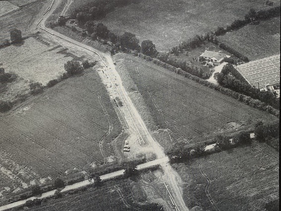
The site lies in a field beside and south of the Ballyboughal road on a north-facing slope the summit of which lies at the field boundary between this site and the medieval site also investigated (report No.17, 1988). Traces of a large, curvilinear ditch and other linear ditches/drains had been noted on the vertical aerial photographs of the pipeline in the area prior to construction, but the remains represented did not clearly indicate the presence of an enclosure as such.
The Remains
Burials on this site were revealed during removal of topsoil and the enclosure ditch was suggested by the presence of dark, humic, charcoal flecked soil to the north and south of the skeletal remains. The pipeline corridor apparently crosses the eastern portion of a large oval enclosure; photographs taken by Leo Swan, in suitable conditions during the excavation, clearly display the outline of a double-ditched enclosure. The cemetery thus lies in the east south east quadrant of the interior. One sherd of E-ware along with fragments of medieval pottery (Leinster cooking ware) and a few ferrous and non-ferrous artefacts, all in redeposited material, were recovered during excavation.
To the south of the burials, around the area in which the internal ditch was located and excavated, there are a great number of shallow ditches, gullies and depressions, some extending north westwards into the burial area. All excavated portions contained a very similar soil and no evidence was retrieved during excavation which might help to interpret them. The surface of the old ground level had been severely truncated, removing any stratigraphical link, but the presence in some of the fill of obviously redeposited human bone indicated that they post date the cemetery.
Among these features -were two concentric, shallow, U-sectioned gullies with well defined terminals which extended c.2m west of the eastern fenceline just at the southern limit of burial. The fill of one of these produced a dense cache of disarticulated human bone in a heavily charcoal flecked soil.
The outer, southern external ditch appeared, in the trenchline, to be incorporated into the northern side of the field boundary in the area crossed by the pipeline corridor.
At the base of the slope, to the north of the site outside the enclosure, a very deep ‘A’ horizon occurred, caused apparently by repeated flooding of the area. Beneath this layer, slightly up-slope but still outside the enclosure ditches, traces of very rough cobbling were noted but no structural remains apparent. There was not sufficient time to excavate this area, but finds from a trial trench though the deposit suggested a likely post-medieval date for the surface.
No archaeological features occurred to the north of the northernmost burials inside the ditch; the area appeared to have been heavily truncated by cultivation.
The Burials
In all, the poorly preserved remains of 65 individuals were excavated, 7 of which were placed in stone-lined and stone-covered graves also in poor preservation since the stone had decayed and the capstones collapsed. However, the stone from which they were constructed was a shale and thus the lining slabs were flat and the covering slabs appeared to serve as lintels. Many of the other, unlined burials were truncated by cultivation and many had been disturbed in antiquity by later interments.
Burials, where exposed, were concentrated in a 30m long stretch of the pipeline corridor, with the greatest concentration occurring roughly in the central part. They obviously extended both east and west of the area exposed within the pipeline.
The Enclosure Ditches
To the north two ditches were revealed in a trial cutting opened 2m inside the eastern fence line. The inner ditch, 2.2m wide and 1.4m deep, lay c.8m to the north of the northernmost burial and the outer, larger ditch, measuring over 5m wide where excavated and over 2.15m deep, lay 2.5m to the north of the inner one.
At the south of the site the inner ditch, measuring 2.6m wide and 1.5m deep, lay c.6m to the south of the southernmost burials. The possible outer ditch, revealed during trenching as a field ditch incorporated into the field boundary, at a distance of some 9m from the above, was 4.8m wide and 2.5m deep.
Finds
Few artefacts were retrieved. However the presence of a sherd of E-ware, together with the lintel-type graves lends strength to the interpretation of the cemetery as an early Christian one. Some scraps of both ferrous and non-ferrous metal were found, some of it modern. Animal bones were retrieved from the fill of the ditches and from the latter gully features at the south of the site from which soil samples were retrieved for macro-fossil study.
It is hoped that some reference to the site may exist in early historic literature. It is likely, however that the enclosure represents an Early Christian ecclesiastical foundation which had been established in the area prior to the latter establishment on the nunnery dedicated to the Blessed Virgin of the Nativity during the 13th century.
The cover of the 1988 EXCAVATIONS included an aerial photograph, courtesy of Leo Swan, of the Gracedieu site.

