1987:01 - DEER PARK FARMS, Antrim
County: Antrim
Site name: DEER PARK FARMS
Sites and Monuments Record No.: N/A
Licence number: —
Author: C.J. Lynn and J.A. McDowell, Historic Monuments and Buildings Branch, DOE(NI)
Author/Organisation Address: —
Site type: Ringfort - rath
Period/Dating: Multi-period
ITM: E 728724m, N 908788m
Latitude, Longitude (decimal degrees): 54.910233, -5.992479
In 1986 excavation penetrated to the primary levels of the original multi-phase rath and exposed the crushed but intact remains of the lower walls of a central, circular wattle house some 7m in diameter. It was also discovered that all of the contemporary organic bedding and midden deposits in the primary rath were preserved as compressed peaty layers of the type normally found only in waterlogged urban settlements and crannogs. The realisation that remains of wattle walls and organic midden deposits actually survived gave great urgency and interest to the final season of excavation in 1987.
This year the excavation of the lower levels of the rath was completed. In the final phase of the rath (under the mound) five double-walled, circular houses were uncovered, together with wooden internal structures and associated external midden layers. The walls of several houses had collapsed, or had been pushed over, before burial under the mound so that, in one case, the wall survived to an equivalent in height of over 2.5m. The oak door jambs of another house were preserved and were dated by dendrochronological analysis to AD 648 at the Palaeoecology Centre, Q.U.B.
Less well preserved were the remains of at least two earlier phases of wicker houses, the earliest of which rested on a thin fossil soil on subsoil. It appeared that the layout of the settlement and the house type changed little from the first Early Christian period settlement some time before AD 648, perhaps in the 6th century. The earliest enclosure was an annular ditch. Although this ran under the primary rath bank in places, its entrance coincided with that of the rath. Vague shallow features, possibly indicating prehistoric activity, were found under the fossil soil in the surface of subsoil.
A large trial-trench was opened on a small terrace in the field 40m east of the rath entrance. This revealed slight remains of extensive paved surfaces and possible rectilinear wall-footings associated with sherds of souterrain ware. The stone features post-dated several curving gullies. This showed that Early Christian period activity, and even buildings, may have been scattered over a wide area around the mound. Another possibility is that the mound summit was replaced as a dwelling site late in the period by an undefended settlement on the level of the surrounding field. A general account of the site is published in Archaeology Ireland Vol. l, No. 1(1987), 11-15.
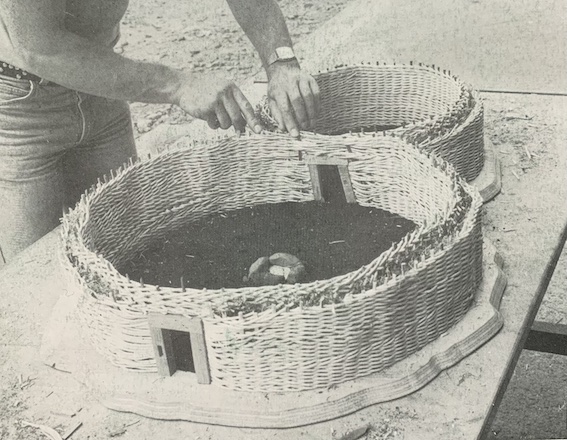
The cover of the 1987 edition of EXCAVATIONS featured a photograph of Declan Hurl making a 1/15 scale model of structures X and Zeta. Up to this level the model is almost a replica of the excavated wattle structures. Copyright DOE(NI).