1986:61 - Tankardstown (BGE), Limerick
County: Limerick
Site name: Tankardstown (BGE)
Sites and Monuments Record No.: N/A
Licence number: —
Author: Christine Tarbett
Author/Organisation Address: 5 St Catherine's Road, Glenageary, Co. Dublin
Site type: House - Neolithic
Period/Dating: Neolithic (4000BC-2501 BC)
ITM: E 558359m, N 628249m
Latitude, Longitude (decimal degrees): 52.404185, -8.611956
During removal of topsoil an L-shaped trench filled with boulders and burnt material was revealed. When this proved to be the obvious foundation trench for a Neolithic house, a request was made to BGE and the landowner to extend the excavation into the wayleave outside the fenced-off corridor. Permission was granted and further excavation of a 10m x 12m area carried out over a five-week period revealed the full ground plan of the house.
The site will be returned to in 1987, with the help of an RIA grant, to test the immediate area around the house for related features.
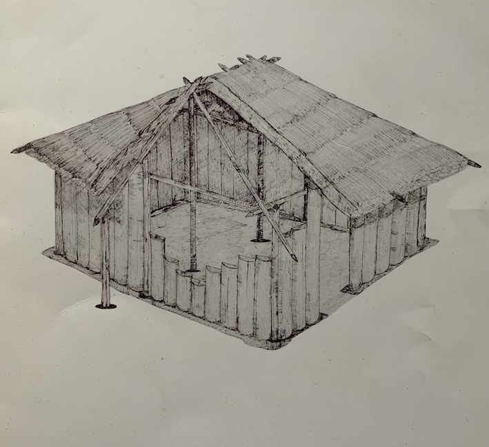
No archaeological deposits survived on the site except in features cut into the boulder clay subsoil. This truncation of features appears to be the result of agricultural activity, though no ploughing had occurred in the area in recent memory. The remains of the house consisted of a rectangular foundation trench 7.4m long and 6.4m wide (external dimensions) varying from 40-80cm in width and 58-69cm in depth.
The house had eight main structural posts. Six of these were set into the foundation trench, one at each corner, and one midway along each of the long sides of the trench. The latter were set on a line with a pair of interior post holes. Thus, the four central, structural posts ran mid-way across the short axis of the house. Only one other internal posthole was noted in the northeast corner of the house. This may have been associated with the entrance or subsidiary roof support in this corner of the house.
The archaeological remains showed that the house had been destroyed by fire. This was indicated by heavy oxidation of the trench sides and the presence in the fill of the trench and post holes of a high concentration of charred material, much of it disturbed.
During excavation, concentrations of charcoal displaying a vertical grain were noted and sampled. Three of these have been identified as Quercus. This appears to indicate that the house may have been built of split oak planks. Identification of further samples of charcoal removed from the trench fill is to be carried out.
One of the two main internal postholes yielded a cache of charred grain, some of which has been identified as emmer wheat. Evidence for the position of a possible hearth site occurred as a concentration of slightly oxidised clay in the centre of the house between the two main interior posts.
The entrance appeared to be placed at the north side of the house and was only indicated by a deposit in the trench of primary, unburnt backfill 1.2m wide.
Finds include a range of small fragments of Western Neolithic pottery, several flint implements including a fine, lozenge-shaped arrowhead, and a number of quartz implements and struck fragments. All the animal bone found on the site was severely burnt. It is unlikely that these remains were burnt in a domestic refuse context. Also it was clear during excavation that the bone fragments had not been burnt in-situ within the foundation trench. It may therefore indicate some sort of ritualised deposition during the construction of the house.
The charred plant remains from the site appear to be one of the best samples from a Neolithic context in this country. Examination of the remains is being carried out by Mick Monk, UCC.
A reconstruction of this house appears on the front cover of EXCAVATIONS, 1986.