1979:023 - AGHACARRIBLE, CO. KERRY, Kerry
County: Kerry
Site name: AGHACARRIBLE, CO. KERRY
Sites and Monuments Record No.: SMR KE054-020
Licence number: E1074
Author: MICHAEL RYAN
Author/Organisation Address: —
Site type: Iron Age and early medieval graves, c. 300 BCc. AD 1200 3
Period/Dating: —
ITM: E 451204m, N 599735m
Latitude, Longitude (decimal degrees): 52.129436, -10.173356
Introduction
In October 1979 a slab-lined grave containing an inhumation was discovered accidentally near Lispole, Co. Kerry. Five capstones were visible in situ at the time of discovery. The site was reported to the NMI by the landowner, Mr Ted Creedon, and was excavated over two days by Michael Ryan.
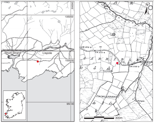
Location (Fig. 4.11)
The site was in the townland of Aghacarrible on the south side of the Dingle peninsula, approximately 2km south-west of Lispole.26 The Aghacarrible stone, which bears rock art of Bronze Age date, lies within 15m of the site. Ryan noted that an adjacent feature in a field bank may have been the remains of a cist, while two elongated stones, apparently bedded in the ground in the vicinity of the recently discovered grave, almost certainly marked the presence of a further undisturbed burial structure. The archaeological survey of the Dingle peninsula lists a second grave from the townland, approximately 100m from the grave discussed here (Cuppage 1986, 66).27
Description of site
The grave consisted of a long, narrow, rectangular slab-lined pit, aligned south-southwest/north-north-east. The grave measured 2.1m in length at the top of the lining slabs and 1.7m at the base by 0.3m high. The lining slabs were markedly inclined and rested against the sides of the pit, not firmly bedded in the ground. Five capstones were found in situ and two of these had collapsed into the grave. The floor of the cist was unpaved.
The grave was filled with mud following heavy rain at the time of discovery. In the midsection of the grave on its subsoil floor was a portion of a human cranium (1979:102).
Comment
This burial is dated on the basis of its form. Owing to the poor survival of bone from this site, it has not been radiocarbon-dated. Given the likelihood that other graves exist in the townland, it is possible that this burial is part of an early medieval ancestral cemetery that fell out of use in the eighth or ninth century when burial in consecrated ground became the norm.
26. Parish of Kinard, barony of Corkaguiny. SMR KE054-020——. IGR 051222 099679.
27. IGR 051230 099650.