1974:046 - BALLYWEE, Antrim
County: Antrim
Site name: BALLYWEE
Sites and Monuments Record No.: N/A
Licence number: —
Author: Mr. C. J. Lynn, Historic Monuments Branch, Department of Finance
Author/Organisation Address: —
Site type: Ringfort - rath
Period/Dating: Medieval (AD 400-AD 1600)
ITM: E 721726m, N 889793m
Latitude, Longitude (decimal degrees): 54.741409, -6.109538
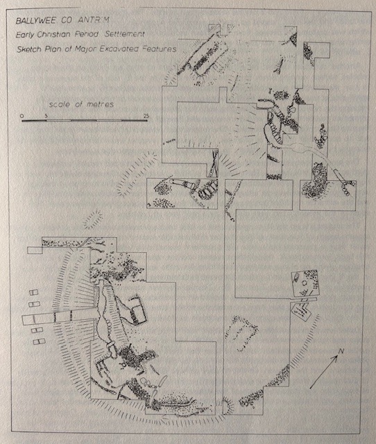
The site, lying on a boggy patch of the E. slope of Donegore Hill was first described and drawn for the Ordnance Survey Memoir of the Parish of Donegore (1) where it is shown in schematic outline as two raths conjoined in a figure 8, 85m approximately in maximum dimension lying almost N-S. A souterrain lay inside covered by a low bank, which was concentric with the W bank of the larger southern enclosure and there was another, rectangular in plan, inside the smaller “rath” to the N. Boyle asserted that the souterrains were then intact and mentioned that shortly before his time the owner had attempted to cultivate the interior but had to give up as “this was attended by his wife’s partially losing her intellects which she has not since recovered”, and remarked that the fort was therefore likely to remain in its present state for some considerable time.
Application for subsidy to level the site was made by the owner at the end of 1974 and since it was not administratively possible at the time to have the site preserved excavations were started. Before digging commenced the sites of the souterrains, which had been wrecked and filled in sometime in the late 19th century, and several platforms and enclosures with stones protruding through the turf were traceable on the surface. The banks of the rath(s) were very low and indistinct and were entirely absent on the E side; this was thought also to be the result of earlier levelling but the excavation showed the sites to have been little disturbed, except for the souterrains, and the O.S. Memoir plan should be considered a schematic conjectural reconstruction.
It was hoped to be able to demonstrate a chronological distinction between the two low earthworks, one perhaps having been added to the other. It was found that the features and structures, exclusively of rounded boulders, lay under a very thin covering of peaty topsoil with the result that it was possible to strip an area of approximately 1,500 sq. metres.
The larger enclosure has a slight bank on the uphill, W side with a gully 5-10 cm deep and 15-20 cm wide further upslope but no ditch; the low bank was carefully revetted with boulders and inside was a further bank covering the collapsed souterrain- a 17m long passage with two oval chambers, the innermost of which was ventilated by a dry stone-built air-shaft leading from a concealed opening at the bottom of a revetment wall supporting the bank downslope to the E The souterrain was entered from the interior of a house, rectangular in plan, 8m x 16m approximately at the S end of the souterrain’s bank which curved around and enclosed the dwelling which was defined by kerbs of boulders on edge, giving the whole structure an appearance reminiscent of a megalithic court and passage. The house was approached from the SE by a heavy pavement with kerb edges and an attached stone-built drain; the paving stopped along the line of the S wall but another narrower paved approach on the E clearly led through a door. The house floor was closely paved, at least on one side, and there was a central stone-kerbed hearth. The make-up on which the house was built and the bank heaped up over its associated souterrain contained occupation debris which was presumably derived from a previous occupation on the site; evidence for several earlier phases of activity was found elsewhere, notably under the cobbled surface near the S side of the house.
Another structure defined by a low kerb of boulders on edge was built on the sloping cobbled surface running down from the revetment wall at the E side of the souterrain bank. In plan the structure was 5m x 3m approximately and was apparently open to the W uphill side across which ran a neatly paved path as far as a row of boulders presumably marking the site of an internal dividing wall; this internal division and the S wall were connected to the revetment wall by two parallel lines of small boulders perhaps indicating the positions of lighter screen walls. The interior was levelled off with clean gravel and there was no occupation material or charcoal. The structure is rather small to represent a byre for example but it was almost certainly an out-building for some agricultural purpose.
The junction between the enclosures was occupied by a flat-topped mound containing a third souterrain still intact. This comprised an oval chamber 5m x 2m approximately with a horizontal air-shaft. The chamber was entered originally through a 6m long creep passage with a rock-cut post hole on either side of the sunken entrance but this was partly filled in and the entrance modified to become a vertical slot half-way along the earlier creep. The edges of the mound’s top were defined by a neat kerb of boulders.
The smaller site on the N turned out not to have been a complete enclosure but merely a short arcuate length of low bank with a shallow ditch outside apparently designed to divert surface water from a structure built on a slight platform immediately within. The internal kerb of this bank formed the W side of the structure and the other edges were defined by a line of boulders giving on plan a rectangular building 4m x 8m approximately, probably with a door in the N (narrow) wall and a carefully paved path running up the centre flanked by 4 postholes on the NW, and 2 on the SE. The building was apparently used as a dry store, the path providing access to material stacked on either side. The only finds made inside were two iron knives. This may have superseded a similar structure built over during the construction of the third rather more complicated souterrain to the E.
Other less distinct evidence of occupation, such as isolated paths, hearths, cobbled areas, walls, stone settings etc, came from other parts of the sites as well as some traces of demonstrably earlier phases of occupation. It would seem that there had initially been an open settlement which was embraced on the uphill W side only by the low-kerbed bank. The dwelling, souterrains, and the outwork on the N were perhaps built rather later but it was not possible to distinguish a clear sequence archaeologically. Earlier occupation levels were not fully explored as excavation was stopped in each of the stripped areas when the latest stone structures were exposed, and another area opened; it was felt that the presence of such clear and fairly solid features might lead to the eventual presentation of at least a part of the site. Common as they are, it is seldom that an Early Christian period settlement reveals structures which might be potentially presentable. As a result of representations made by Professor Evans and Dr. G. Eogan, the Department of Finance is now considering taking the site into State Care and conserving it.
Finds, mostly from the area of the dwelling, included souterrain ware, ring pins, glass beads, fragments of lignite bracelet, a spindle-whorl and a quern, but, apart from a silvered and highly decorated bronze buckle, were unremarkable from a rath in this area. However, the significance of the site remains in the state of preservation, number and complexity of the dry-stone built features; these are carefully laid out and, neat, far beyond what would have been necessary for mere survival and seem to demonstrate an interest on the part of the builders in the quality and appearance of their work.
- Ordnance Survey Memoir for the Parish of Donegore (Belfast, 1974) 30—1, P1.18