1973:055 - DÚN ÁILLINE (Knockaulin td), Kildare
County: Kildare
Site name: DÚN ÁILLINE (Knockaulin td)
Sites and Monuments Record No.: N/A
Licence number: —
Author: Dr. B. Wailes, Dept of Anthropology, University of Pennsylvania
Author/Organisation Address: —
Site type: Hillfort
Period/Dating: Iron Age (800 BC-AD 339)
ITM: E 681933m, N 707832m
Latitude, Longitude (decimal degrees): 53.114746, -6.776126
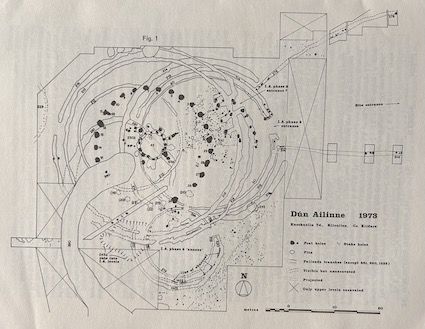
The remaining portion of the ‘low mound’ (Iron Age phases 4, 5, 6) was removed, in the course of which it became apparent that the circle of large postholes (1-30) was erected during the ‘life’ of the two concentric palisade trenches (515 and 516) that define I.A. phase 3. The former phases 3 and 4 thus are combined now into I.A. phase 3, the former I.A. phases 5, 6 and 7 becoming phases, 4, 5, and 6. This clearance of the ‘low mound’ revealed a complete occupation surface of I.A. phase 3 over a substantial area inside the presumed entrance into the main structure of that phase: the heavy concentration of postholes and stakeholes shown on the plan are all of this phase.
The central feature of I.A. phase 3 is feature 42, completely cleared in 1973. It is a roughly circular wooden structure c.6.0 metres maximum diameter. The floor is cut down below the surrounding surface, and there is no entrance- the wall-trench is continuous, and no gap between wall-posts showed a surface, over trench-fill, that extended from interior to exterior. Adjoining 42, to the W.N.W., is a smaller structure, feature 2302. The wall-posts of feature 42 are very substantial for a structure of such modest horizontal dimensions, and it is surrounded by an external ring of nine irregular holes, at least six of which originally supported large posts (buttresses?). A structure of some considerable height seems possible. At all events, the whole complex is non-domestic, non-residential and non-industrial.
I.A. phase 2 is defined by the concentric palisade trenches 60, 513 and 514: these are all completely cleared except for a small area on the S.W. The main work on this phase in 1973 was on the ‘annexe’ to the south of the main structure. Although by no means completely cleared, sufficient has been identified to show a circle of two concentric palisade trenches, the outer one of which divides to give three trenches on the S. side. Against the inner edge of trench 520/1422 there appears to be the remains of burnt upright planking- perhaps an inner facing to a post palisade.
To the S.E. and E. of the I.A. phase 2 ‘annexe’ there are rough lines of small postholes and stakeholes running N.E.-S.W. So far, these cannot be related stratigraphically to any identified phase on the site, but their tangential relationship to, and avoidance of, the I.A. phase 2 ‘annexe’ suggest that they may be of that phase. There are now features, certainly or probably prehistoric, outside the central area to the E, S.E., S, S.W. and W, suggesting that activity within the 34-acre enclosure was rather more extensive than was apparent at the beginning of the excavation, in 1968.

