1973:072 - GARRYHUNDON, CO. CARLOW, Carlow
County: Carlow
Site name: GARRYHUNDON, CO. CARLOW
Sites and Monuments Record No.: SMR CW012-135SMR CW012-025SMR CW012-027
Licence number: E1034
Author: ELLEN PRENDERGAST
Author/Organisation Address: —
Site type: Late medieval graves, c. AD 12001600, and post-medieval graves, AD 16001800
Period/Dating: —
ITM: E 672208m, N 669370m
Latitude, Longitude (decimal degrees): 52.770538, -6.929915
Introduction
In August 1973 human remains were discovered during work on a sandpit at Garryhundon, near Carlow town. Although the pit had been worked for over twelve years, this was the first time that human remains had been discovered. The human bone was noticed by the bulldozer driver in a scoop of gravel taken from near the surface of the pit. The bones were retrieved and the Gardaí at Carlow were informed of the discovery. The area was left undisturbed pending a site examination. The NMI was informed the following day by Sergeant Caesar of Carlow Garda Station, and a rescue excavation was carried out by Ellen Prendergast.
Location (Fig. 5.1)
The site was located in the townland of Garryhundon in east County Carlow, some 7km south of Carlow town.2 It was 2km west of the River Barrow, which separates the baronies of Carlow and Idrone West. The site lies at an altitude of 60–70m above sea level in a broad river valley. Other recorded sites in the townland include ecclesiastical remains and a burial ground.3 An enclosure marked approximately 200m north of the burials is identified by Dáibhí Ó Crónín as Ráth Maelsigi, where there existed a community of Anglo-Saxon monks in the seventh/eighth centuries (Ó Crónín 1984).4
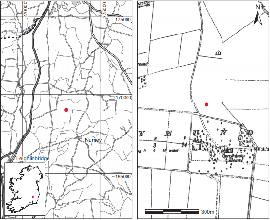
Fig. 5.1—Location map, Garryhundon, Co. Carlow.
Description of site
The vertical face of the sandpit was exposed to a depth of about 10m in the area of the discovery. The original ground surface had been scarped away to a depth of about 0.15m. Grass had grown again on the scatter of earth overlying the gravel. Pockets of clay were visible just underneath the surface; underneath these were various thick layers of sand, which overlay a thick layer of gravel.
The bones lay in a deposit of soil approximately 0.6m below ground level. As no structural stones were noticed in the area, it would appear that the burial had been in a simple dug pit. As the face of the sandpit was slightly undercut and large sections had collapsed after rainfall, it was unsafe to excavate the area around the burial. No other bones were visible in the area, however. The face of the pit was further scraped with the bulldozer scoop and the material was examined, but no remains were found.
The grave had contained an inhumation burial but the position of the skeleton (1973:46) was not noted prior to its disturbance by the bulldozer. No associated artefacts were found. The bones recovered comprised the upper portion of a skeleton: a skull, two humeri, a clavicle, a scapula, two vertebrae, three rib fragments and some miscellaneous fragments. Most of the bones had been partially bleached, apparently owing to exposure in the face of the pit. It is probable that the missing portions of the skeleton had been lost in the bulldozing operations.
Comment
A sample of the remains was submitted for radiocarbon dating and yielded a date of 230±40 BP, which calibrates to an extremely broad date range of 1521–1955.5
2. Parish of Clonmelsh, barony of Carlow. SMR CW012-135——. IGR 272806 169042.
3. SMR CW012-025——; IGR 272274 169330.
4. SMR CW012-027——; IGR 272670 169240 .
5. GrA-29064.