1969:047 - GALLOWSHILL, CO. KILKENNY, Kilkenny
County: Kilkenny
Site name: GALLOWSHILL, CO. KILKENNY
Sites and Monuments Record No.: SMR KK019-034
Licence number: E1100
Author: MICHAEL RYAN
Author/Organisation Address: —
Site type: Graves of indeterminate date
Period/Dating: —
ITM: E 651668m, N 654957m
Latitude, Longitude (decimal degrees): 52.643364, -7.236540
Introduction
In September 1969 human remains were discovered during quarrying operations on the outskirts of Kilkenny City. The bones had fallen down the section of the quarry and were collected by the Gardaí when they visited the site. The discovery was reported to the NMI by
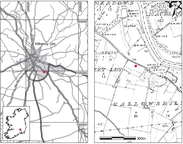
Fig. 6.24—Locationmap, Gallowshill, Co.Kilkenny.
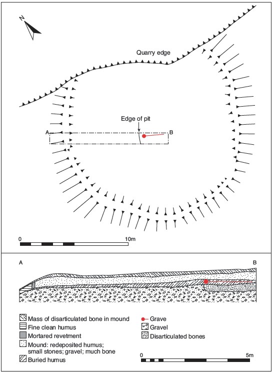
Fig. 6.25—Plan of site,Gallowshill, Co.Kilkenny.
Gardaí at Kilkenny, and the site was visited by Ellen Prendergast in September 1969. In 1975, when further burials were found at the site, a preliminary visit was made by Barry Raftery and Eamonn Kelly, and a rescue excavation was undertaken by Michael Ryan.
Location (Fig. 6.24)
The site was in the townland of Gallowshill on the southern outskirts of Kilkenny City.41 It was located on a prominent esker that had been exploited for gravel by Kilkenny County Council. According to Ellen Prendergast, there is no reference to the site in Carrigan, Hogan or O’Donovan’s writings on the area, and the name Gallowshill was not used in the Down Survey.
Description of site
At the time of Kelly and Raftery’s visit to the site, human remains were strewn about the base of the cliff face. More bones were visible protruding from the cliff face near the summit. These appeared to represent the remains of at least one adult individual. A small circular earthwork was noted on the surface of the quarry. This comprised a low bank, 0.5–0.75m high and 2m broad, enclosing an area 14m in diameter (Fig. 6.25). Approximately one quarter of this had been destroyed. The structure was investigated by Ryan and was found to be of fairly recent date, comprising material scraped from the surrounding area and revetted in place by a small kerb of irregular stones, mortared together. It is possible that the structure was connected to the castle gardens. It was clear, however, that it was unrelated to the burials found here. There does not appear to have been evidence for structural stones or wood associated with the burials, which were found over an area measuring approximately 150m.
The burials were all inhumations, but as they were disturbed it was not possible in most cases to determine their disposition. One shallow pit contained a partly articulated skeleton (1975:240) aligned west-north-west/east-south-east. The fill of the pit was composed of redeposited gravel and disarticulated bone (1975:241).42
Comment
In the absence of associated finds or other dating evidence it is not possible to determine the age of these burials.
41. Parish of St Patrick, barony of Shillelogher. SMR KK019-034——. IGR 251729 154914.
42. Also collected and acquired were a portion of a glass bottle, 1975:242; a chip of china with blue glaze, 1975:243; a sample of mortar from the modern structure, 1975:244; and a horse tooth 1975:245. The human remains from the earlier investigation are numbered 1969:827.