1969:050 - TIEVEBANE, CO. DONEGAL, Donegal
County: Donegal
Site name: TIEVEBANE, CO. DONEGAL
Sites and Monuments Record No.: SMR DG038-041
Licence number: E1055
Author: EAMONN P. KELLY
Author/Organisation Address: —
Site type: Early Bronze Age graves
Period/Dating: —
ITM: E 636471m, N 923899m
Latitude, Longitude (decimal degrees): 55.061243, -7.429107
Introduction
In November 1978, a short cist that had first been discovered in 1969 was relocated during spring ploughing. The site was on the southern end of the Inishowen peninsula in County Donegal. At the time of the initial discovery a complete vase was reported to have been the only contents of the cist. It was removed and subsequently broken, but the damaged vessel was acquired by the NMI in 1971. The cist had been resealed on discovery in 1969. When the capstone was relocated in 1978 it was decided to excavate the grave. The cist was excavated by Eamonn P. Kelly.
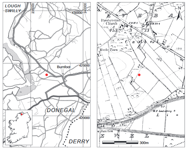
Location (Fig. 3.49)
The cist was in the townland of Tievebane, north-east Co. Donegal, just across the border from Derry city.70 It was on a low ridge overlooking a broad, flat valley to the south-east and south, at an altitude of 15–30m above sea level. To the north-east the site is dominated by Cashel Hill. To the west-north-west and south-west it is overlooked by higher ground. The cist lay 25m from the high point of the ridge, which slopes from south-west to north-east.
Description of site
The cist was subrectangular in plan, with its long axis running north-west/south-east. It measured 0.75m long by 0.4m wide by 0.46m high (Fig. 3.50). It was constructed of four main
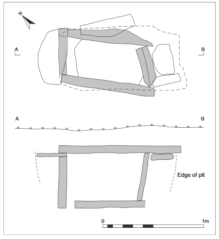
Fig. 3.50—Plan and section of grave, Tievebane, Co. Donegal.
slabs set on edge, one forming each wall. One thin slab had been placed on top of the north-western end slab, and a second on the north-eastern side slab, so that the capstone rested level on all four walls. A number of packing stones were also visible outside the south-eastern end and the eastern side. The cist was covered by a large capstone, which extended out beyond its south-eastern end. The floor of the cist was paved with a single slab. The pit dug to receive the
cist was visible in the upper levels of the section and was 1.38m long. Owing to the fact that the cist had been discovered and the contents disturbed some time before the excavation, the original context of the find was not established. When it was reopened in 1978, the cist was empty except for a small amount of ploughsoil in the north-north-western corner. Apparently the tripartite vase was found upright in the centre of the cist, but no bone was discovered.
Tripartite vase, 1971:1130 (Fig. 3.51)
Several large sherds of rim and body and one small piece of the base of the vase are preserved. The rim bevel is decorated with horizontal lines of twisted cord impressions and short incised lines. Twisted cord impressions occur on the upper exterior and incised herringbone below the shoulder, apparently to the base (Ó Ríordáin and Waddell 1993, 101). The decoration is quite crudely executed and the patterning lacks form and consistency.
Dimensions: estimated D rim c. 13cm; estimated H 11.5cm; T wall 1.37mm.
Comment
On the basis of its form and decoration this vessel is comparable to those ascribed to stage 1 of the development of the vase series by Brindley (2007, 254–8), which is dated to

Fig. 3.51—Ceramic Vessel, Tievebane, Co. Donegal.
2020/1990–1920 BC. The vessel resembles in particular two vases from grave 1, Cloughskelt, Co. Down. In the absence of any human remains or charcoal it has not been possible to date this site by radiocarbon.
70. Parish of Fahan Upper, barony of Inishowen West. SMR DG038-041——. IGR 236527 423914.