1965:011 - DEANSGRANGE, CO. DUBLIN, Dublin
County: Dublin
Site name: DEANSGRANGE, CO. DUBLIN
Sites and Monuments Record No.: SMR DU023-042
Licence number: E1060
Author: BREANDÁN Ó RÍORDÁIN
Author/Organisation Address: —
Site type: Early Bronze Age graves
Period/Dating: —
ITM: E 722585m, N 726157m
Latitude, Longitude (decimal degrees): 53.271572, -6.162141
Introduction
In April 1965 a short cist containing an inhumation burial was discovered during gardening in Foxrock, Co. Dublin. The landowner, Mr John Philips, removed the bones from the cist and brought them to the Loughlinstown hospital for examination. The site was subsequently visited by a hospital doctor and members of An Garda Síochána, who concluded that the site was of ‘considerable antiquity’ and should be reported to the Museum. The site was investigated the following day by Mr Breandán Ó Ríordáin, and a one-day rescue excavation took place (Pl. 25). The human remains from the cist were examined by Professor J.B. Coakley. This report is based
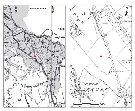
Fig. 3.58—Locationmap, Deansgrange,Co. Dublin.
on Ó Ríordáin’s site report and on Coakley’s examination of the human remains.
Location (Fig. 3.58)
The site is in the townland of Deansgrange, south-east Co. Dublin.82 It lay on flat ground that formed a portion of the back garden of a dwelling house. The site lay at an altitude of approximately 30–60m above sea level. No other early Bronze Age sites have been found in the townland.
Description of site
The cist was rectangular in plan, with its long axis aligned north-west/south-east. Internally it measured 0.63m long by 0.4m wide by 0.44m deep. It was made up of four granite slabs set on edge, with one making up each wall. The slabs appeared to be relatively regular in shape, with a maximum length of 0.68m and a maximum width of 0.22m. The south-eastern end slab was the shortest, measuring 0.42m long by 0.1m thick. There was no evidence for packing stones around the outside of the cist. The capstone, also of granite, had been broken by the finder. It was irregular in outline, measuring 0.95m long by 0.6m wide by 0.15m thick. When found, it lay approximately 0.3m below the original ground surface. The floor of the cist was not paved. Two stones which appeared to have fallen into the grave were removed in the course of investigation. The pit dug to receive the cist was not located. The cist contained the unburnt remains of two adults (1965:11) and no accompanying artefacts were found. Unfortunately the entire contents had been removed by the finder, so their exact location within the cist is not known.
Comment
The human remains from this site have not been dated. It is assumed, based on its form, thatthe cist dates from the early Bronze Age.
HUMAN REMAINS
J.B. COAKLEY
NMI 1965.11—fragments of two adult skulls can be identified. Three fragments of mandible, which could be part of the one bone; ten teeth showing signs of wear, molars showing signs of considerable wear. Fragments of upper and lower limb bones, ribs and vertebral column. Age: 35 years plus (though possibly much older). Some of the fragments show male characteristics.
emsp;One small fragment of non-human bone.
82. Parish of Kill, barony of Rathdown. SMR DU023-042——. IGR 322661 226130.