1964:017 - GORTNATRAW SOUTH, CO. DONEGAL, Donegal
County: Donegal
Site name: GORTNATRAW SOUTH, CO. DONEGAL
Sites and Monuments Record No.: SMR DG027-007
Licence number: E1053
Author: PETER DANAHER
Author/Organisation Address: —
Site type: Early Bronze Age graves
Period/Dating: —
ITM: E 621634m, N 933128m
Latitude, Longitude (decimal degrees): 55.145017, -7.660641
Introduction
In April 1964 a short cist was discovered during the digging of foundations for a dwelling house north-east of Milford, Co. Donegal. The capstone of the cist, which lay approximately 0.25m below the surface, was broken into fragments during the discovery and the contents of the grave were shovelled out and deposited nearby. Some fragments of pottery were found in this material and work on the site ceased. Local newspaper correspondent Samuel Kerr heard of the find, visited the site and subsequently reported it to the NMI 58by telegram. The NMI then contacted the local Garda Síochána, who visited the site over the weekend. The cist was investigated over three days (27–29 April) by Peter Danaher. This report is based on Danaher’s excavation report and also includes a petrological analysis by Dr J. Jackson, former Keeper of Natural History.
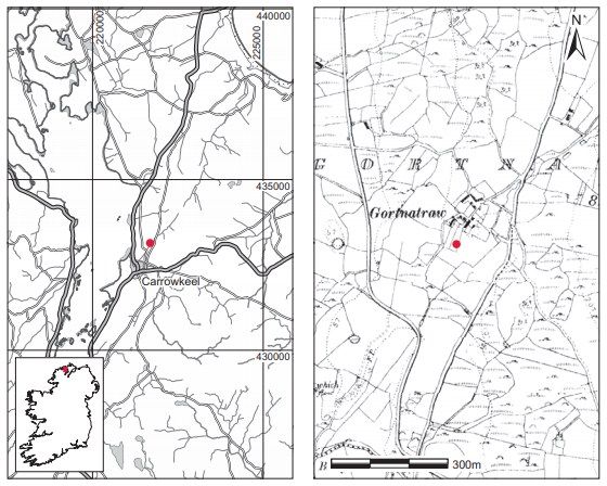
Location (Fig. 3.38)
The site was in the townland of Gortnatraw South, on the Fanad peninsula, north Co. Donegal.59 It lay on the summit of a natural gravel ridge, approximately 42m above sea level, overlooking the eastern shore of Mulroy Bay, with Knockalla Mountain to the south-east. Peter Danaher describes the original ground surface and humus as being ‘tinted an orangebrown-rusty colour’. No other cists are known from the immediate area but two sherds of coarseware were found in Gortnatraw South townland and came to the NMI through the D’Evelyn collection.60
Description of site
The cist was subrectangular in outline, with its long axis aligned north-north-west/southsouth-east. Internally it measured 0.9m long by 0.55m wide by 0.57m high (Fig. 3.39). It consisted of five main side slabs set on edge, one each on the northern, western and southern sides, and two on the eastern side. The latter two had been placed end to end but met at an angle so that the eastern wall of the cist splayed outwards slightly at this point. The western side slab was the largest, measuring 1.08m long by 0.62m high by 0.22m thick. The maximum thickness of the other side slabs was 0.1m and the maximum length 0.69m. These slabs were also lower in height, those at the east being approximately 0.41m high,and had to be built up with drystone walling to support the capstone.61
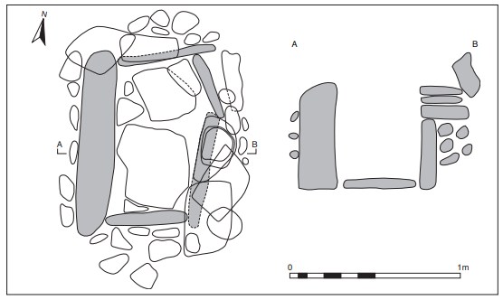
The support stones were laid flat on the side slabs and are indicated in the north-west corner of the cist and on the east side. Small spalls were used as packing stones both around the side slabs and possibly over the edges of the capstone. Unfortunately, the capstone was removed and broken before Danaher’s investigation, so its exact disposition cannot be verified. The floor of the cist was paved with two large flags, averaging 0.07m in thickness, with a few smaller stones interspersed. The excavator does not make reference to the pit dug to receive the cist. The grave fill contained fragments of a tripartite bowl but no evidence for bone or other artefacts was found. As described above, the contents of the cist had been removed before excavation. Examination of this material yielded further fragments of the vessel.
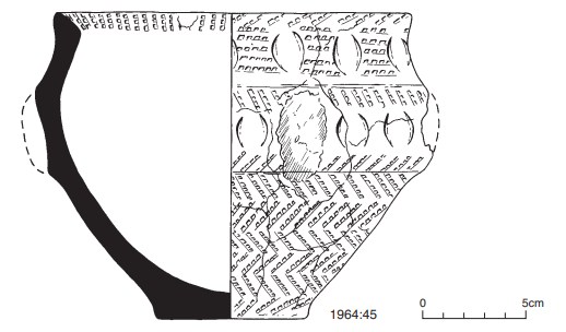
Tripartite bowl, 1964:45 (Fig. 3.40)
Approximately two-thirds of the vessel survives, with the remaining portion reconstructed with plaster. The fabric is thick and coarse, with stony grits. Surfaces are smooth, yellowbrown in colour with a black core. The decoration consists of parallel lines of comb impressions, set horizontally just underneath the rim and in a vertical herringbone pattern throughout the remaining portion of the vessel. Some lunate impressions occur on the neck and shoulder also. There were probably four (or six) imperforate lugs attached to the vessel originally but only a portion of one of them now remains. The internal bevel of the rim is decorated with transverse rows of comb impressions. The base is plain.
Dimensions: max. H 15cm; ext. D rim 17.4cm; int. D rim 14.7cm; D base 7.7cm.
Comment
As the contents of the cist had been shovelled out, any human remains would have been disturbed and removed from the cist. As this material yielded some sherds of the vessel, any bone present should have been found also, but none is recorded. Consequently it has not been possible to date this burial by radiocarbon analysis. Ó Ríordáin and Waddell (1993, 100) note that the vessel is a tripartite bowl with unusually coarse comb and lunate impressions. In terms of the bowl tradition typological sequence recently developed by Brindley (2007, 165–77), this vessel fits best with the stage 3 vessels, which are dated to 1980–1932/20 BC.
PETROLOGY
J.S. JACKSON
Samples of stone from cist
1. A fragment of mica-schist.
2. A fragment of ferroginous quartzite.
3. A fragment of quartzite.
4. A fragment of banded quartzite, iron-rich in part.
They are pre-Cambrian and [represent the] whole suite of Donegal Dalradian facies. The rocks are acidic and the soil is likely to be acidic also.
58. Mr Kerr had also reported the Bronze Age pit burial from Dunmore, Co. Donegal (some 3km south of here), four years previously; see report on Dunmore, Co. Donegal, this volume, p. 134.
59. Parish of Clondavaddog, barony of Kilmacrenan. SMR DG027-007——. IGR 221687 433144.
60. 1934:1976–7. The ware is coarse and undecorated with a black core and contains some large grits.
61. It was not possible to obtain the maximum height of the side stones as only one section is drawn.